How do the hurricanes amplify?
How do the hurricanes amplify?. Review of last lecture. Tropical cyclone genesis: Western Pacific has the highest averaged number per year 6 necessary conditions for tropical cyclone genesis 4 stages of tropical cyclone genesis Tropical cyclone tracks
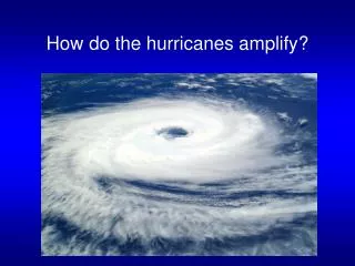

How do the hurricanes amplify?
E N D
Presentation Transcript
Review of last lecture • Tropical cyclone genesis: Western Pacific has the highest averaged number per year • 6 necessary conditions for tropical cyclone genesis • 4 stages of tropical cyclone genesis • Tropical cyclone tracks • Tropical cyclone intensity scale. Category 1: 74mph, category 5: 155mph • Hurricane names: alphabetically, 6 lists in rotation • Trends and variability in tropical cyclone activity
Video: Hurricane Structurehttp://www.youtube.com/watch?v=OEPZOC6YHUc
Horizontal Structure of tropical cyclones • Total diameter: about 600km • Lifetime: up to a week or more • Make up: many thunderstorms arranged in pinwheel formation • Three components: • 1. Central eye - clear skies, light winds (25 km diameter) • 2. Eye wall - strongest winds (can be 200 mph), max precip. (up to 2500 mm/day) • 3. Spiral rainbands • Cylonic inflow, anticyclonic outflow. Outflow creates cirrus shield that often obscures pinwheel structure
Vertical Structure: Heating, temperature, pressure and wind • Warm core - fueled by thermal energy - core warmer than outside at upper levels • Maximum rainfall occur in the region of eye wall • Minimum surface pressure occurs in the region of central eye • Maximum winds occur in the region of eye wall H L
Eye wall replacement • A shrinking eye indicates storm intensification. • Some intense hurricanes develop double eye walls, as rain bands contract and intensify. • Eye wall replacement leads to weakening of the hurricane winds, followed by renewed strengthening.
Vertical Structure: Feedbacks Sea surface temperature Convergence-Convection (CISK): positive Surface flux-Convection (WISHE): positive Air-sea interaction: negative
Video: Landfall of Hurricane Sandyhttp://www.youtube.com/watch?v=YeutC1WN6dc
Tropical cyclone Destruction and Fatalities • Destruction caused by: • Hurricane-scale winds (>74 mph) • Rainfall (10 in/day) • Storm surge (winds blowing coast-ward + lower atmosphere pressure) • Fine-scale Tornadoes • Destruction most intense on right side of cyclone (wind + storm speed)
Hurricane-spawned tornadoes • More than half of the landfall hurricanes produce at least one tornado • Hurricane Buelah (1967) produced 141 tornadoes • Most likely occur in the right-front quadrant • Generally less intense than those that occur in the great plains
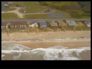
Hurricane Destruction: Storm Surges • The storm surge is a rise in water level induced by a hurricane. They occur as water piles due to heavy winds and low atmospheric pressure and increase with storm intensity. • High surf can occur atop the storm surge, increasing damage. • Winds and storm surge are typically most intense in the right front quadrant of the storm where wind speeds combine with the speed of the storm’s movement to create the area of highest potential impact.
Hurricane Forecasts and Advisories • The National Hurricane Center is responsible for predicting and tracking Atlantic and east Pacific hurricanes. • Data are gathered through satellite observations, surface observations, and aircraft using dropsondes (packaging containing temperature, pressure, and moisture sensors). • Statistical, dynamic, and hybrid computer models running on supercomputers assist in forecasting track position and storm intensity. • Future positions are given along six-hour trajectories with accuracy decreasing as lead time increases. By Tim Marchok of NOAA/GFDL
Hurricane Watches and Warnings • A hurricane watch is issued if an approaching hurricane is predicted to reach land in more than 24 hours. • If the time frame is less, a hurricane warning is given. • Tropical storm watches and tropical storm warnings are issued with the same anticipated lead time. • The erratic nature these storm systems leads to difficulties in exact prediction, warning, and evacuation.
Summary • Tropical cyclone structure: 3 major components, rotation direction of inflow and outflow, location of maximum wind and rainfall, 3 feedbacks • Tropical cyclone destruction: 4 reasons? Which side has the most intense destruction? • Tropical cyclone forecast: track and intensity Currently which skill is better?