Download
1 / 25
270 likes | 520 Vues
GOES-R Cloud and Microphysical Products, Fog and Low Stratus. Andy Heidinger Michael Pavolonis NOAA / STAR Patrick Minnis NASA Langley Research Center Andi Walther Scott Lindstrom University of Wisconsin-Madison CIMSS (Cooperative Institute for Meteorological Satellite Studies).

E N D
GOES-R Cloud and Microphysical Products, Fog and Low Stratus Andy Heidinger Michael Pavolonis NOAA / STAR Patrick Minnis NASA Langley Research Center Andi Walther Scott Lindstrom University of Wisconsin-Madison CIMSS (Cooperative Institute for Meteorological Satellite Studies)
Cloud Optical Depth Cloud Particle Size Clear Sky Mask Cloud Top Height Cloud Top Phase Cloud Top Pressure, Temperature http://www.goes-r.gov
Learning Objectives Baseline Products • Which ABI bands are used for the Cloud Products • Cloud Product Production order • Temporal cadence and spatial resolution of products • Limitations • Sample uses of products • Clear Sky Mask (i.e., Cloud Mask) • Cloud Optical Depth • Cloud Particle Size • Cloud Top Height • Cloud Top Phase • Cloud Top Pressure
Cloud Mask influences – and must be computed before – many many products! Part of this training Figure from Schmit et al., 2017 If there is a problem in the products ‘downstream’ of Cloud Mask, look at the Cloud Mask to help diagnose the problem
Cloud Product Production Order • Clear Sky Mask (i.e., Cloud Mask) • Cloud Type/Cloud Phase • Cloud Top Temperature/Pressure/Height • Cloud Optical/Microphysical Properties
The first thing created in the product stream : Clear Sky Mask 0.64 mm Clear Sky Mask
Clear Sky Mask • Temporal Refresh • Full Disk Domain: 15 minutes • CONUS Domain: 5 minutes • MESO Domain: 1 minute • 2-km resolution • Assumes clear pixels, tries to find evidence of cloud • Produced out to a Satellite Zenith Angle of 70o • Four categories produced: Clear, probably Clear, Probably Cloudy, Cloudy. AWIPS displays Clear (Missing)/Cloudy (White). • Misclassification is more likely for large zenith angles • Warm low cloud is sometimes misclassified as probably clear or probably-cloudy • Artifacts are most likely in coastal regions and near the terminator. • ATBD for more information
1.61 mm 1.4 mm 0.64 mm What bands are used for ABI Cloud Mask (ACM)? ABI 12 14 15 7 11 13 16 8 9 10 11.2 mm 8.4 mm 3.9 mm 7.3 mm 12.3 mm Band 9 (6.9 mm) is used if Band 10 is not available
Cloud Mask Computed for Satellite Zenith Angle up to 70o (halfway into the yellow is a satellite zenith angle of 70 degrees) Satellite Zenith Angle is 0 at Nadir, and it approaches 90 as you move towards the limb
Algorithm: CLAVR-x Cloud Type Cloud Type (NOT Baseline) Clouds are divided into 7 categories: • Near-sfc • Water • Super-cooled • Opaque ice • Cirrus • Overlap (cirrus over low cloud) • Deep convective cloud (DCC). • ‘Clear’ and ‘Probably Clear’ are derived from the cloud mask. • DCC is convection that has reached the tropopause. • Super-cooled clouds are based on temperature. • Glaciation changes give insight into growing convection. • Use for seeder-feeder situations. • Qualitative way to distinguish cloud layers. • More details in ATBD
Cloud Phase is defined after Cloud Type • Cloud Phase, a baseline product, is derived from Cloud Type • Four Categories: • Warm liquid water (liquid water cloud ; opaque cloud temperature > 273 K) • Supercooled liquid water (liquid water topped cloud ; opaque cloud temperature < 273 K) • Mixed phase clouds (high probability of both liquid water and ice near cloud top) • Ice phase clouds (all ice topped clouds) • Cloud Mask is input • Temporal Refresh • FD: 15 minutes • CONUS: 5 minutes • MESO: 1 minute • 2-km resolution • Computed to a Local Zenith Angle of 65o • Uses Bands 10,11,14,15 (7.3 mm, 8.4 mm, 11.2 mm, 12.3 mm)
Cloud Phase: Baseline Created with every image: 15-minute FD, 5-minute CONUS, 1-minute MESO Liquid Water Clouds Mixed Phase Clouds Supercooled Water Clouds Glaciated with lightning? Seeder-Feeder? Ice Clouds
ABI Cloud Height Requires Cloud Mask and Cloud Phase Full Disk Domain: Every 15 minutes CONUS Domain: Every 5 minutes MESO Domain: Every 1 minute/30 seconds Averages good quality pixels: (FD/CONUS domains): 10-km resolution (MESO domains): 4-km resolution Quantitative to 62o zenith angle Qualitative for > 62o zenith angle Uses ABI Bands 14,15,16 (11.2 mm, 12.3 mm, 13.3 mm) An acronym you might see: ACHA: ABI Cloud Height Algorithm • Dubious results for thin cirrus • Low-level Inversions introduce uncertainty • NWP guidance helps and is used over the ocean with water clouds.
Cloud-top Pressure: derived with Cloud Height Algorithm: AWG Cloud Height Algorithm (ACHA) The atmospheric pressure of the highest cloud layer in the column Part of ABI Cloud Height Algorithm (ACHA) output Full Disk Domain: Every 15 minutes CONUS Domain: Every 5 minutes MESO Domain: Every 1 minute Averages good quality pixels: FD/CONUS: 10-km resolution MESO: 4-km resolution Quantitative to 62o zenith angle Qualitative for > 62o zenith angle Computed using ABI bands 14, 15, 16 • Dubious results for thin cirrus • Aviation Applications
Algorithm: AWG Cloud Height Algorithm (ACHA) Cloud-top Temperature The effective radiative temperature of the highest cloud layer in the column. Generally gives more accurate information than a single window channel Part of ABI Cloud Height Algorithm (ACHA) output Full Disk Domain: Every 15 minutes MESO Domain: Every 1 minute Not computed for CONUS domain! 2-km resolution Quantitative to 62o zenith angle Qualitative for > 62o zenith angle Computed using ABI bands 14, 15, 16 • Dubious results for thin cirrus Default AWIPS color scale from -109 to 55
Algorithm: AWG Cloud Height Algorithm (ACHA) Cloud-top Temperature The effective radiative temperature of the highest cloud layer in the column. Generally gives more accurate information than a single window channel Part of ABI Cloud Height Algorithm (ACHA) output Full Disk Domain: Every 15 minutes MESO Domain: Every 1 minute Not computed for CONUS domain! 2-km resolution Quantitative to 62o zenith angle Qualitative for > 62o zenith angle Computed using ABI bands 14, 15, 16 • Dubious results for thin cirrus Modified AWIPS color scale from -80 to 10 and flipped so blue is cold, red is warm
Why not just use Brightness Temperature for the Cloud Top Temperature? • Which brightness temperature do you use if there are multiple window channels? 8.5 mm? 10.3 mm? 11.2 mm? 12.3 mm? • GOES-R ABI offers more choices – maybe the brightness temperature product is not best – because which value is best?
ABI Infrared Window Bands Width of legacy 10.7 μm spectral response Spectral response functions for AHI window IR bands (that are all similar to ABI bands). The red bar is GOES-15.
Here are Four IR ABI Window Channels (8.4mm, 10.3mm, 11.2mm, 12.3mm) at 1555 UTC Band 13 Band 11 Band 14 Band 15
Here are Four IR ABI Window Channels (8.4mm, 10.3mm, 11.2mm, 12.3mm) at 1556 UTC Band 13 Band 11 Band 14 Band 15
Algorithm: Daytime Cloud Optical and Microphysical Properties (DCOMP) Cloud Optical Depth (Daytime only!) Cloud optical depth (COD) is the integrated extinction (attenuation of 0.64 mm light) due to solid water particles through the column. Computed every 15 minutes for Full Disk, every 5 minutes for CONUS; not produced for AWIPS in Meso domains. Horizontal Resolution: 4 km (Full Disk) and 2 km (CONUS) Computed up to a Satellite Zenith Angle of 65o Computed using Bands 2 and 6 on ABI Compare COD to AOD – which is computed in the absence of clouds This daytime-only product is in AWIPS. A nighttime IR product (using Bands 7, 14 and 15) can be found online
Algorithm: Daytime Cloud Optical and Microphysical Properties (DCOMP) Cloud Particle Size (Day) A single metric representing the most common cloud particle size. Computed every 15 minutes for Full Disk Domains; every 5 minutes for CONUS and every minute MESO domains. Horizontal Resolution: 4 km (Full Disk) and 2 km (CONUS/MESO) Computed up to a Satellite Zenith Angle of 65o Computed using Bands 2 and 6 on ABI Small ice particles in convection indicate strong updrafts. Large water droplets in boundary layer clouds denote precipitating clouds. Cannot separate out influence of multiple cloud layers. Values for cirrus over low cloud are under-estimated. Large uncertainty over bright surfaces. This daytime-only product is in AWIPS. A nighttime IR product (using Bands 7, 14 and 15) can be found online
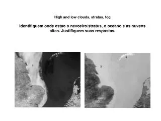
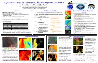
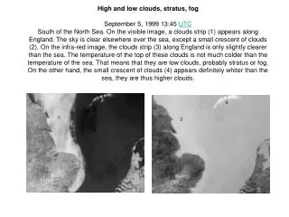
Fog and Low Stratus Brightness Temperature Difference between 10.3mm and 3.9 mm leverages the emissivity differences in water clouds at those two wavelengths Problem: Plain Stratus clouds look a lot like fog from the top – that is, from the satellite!
Solution: Fuse Model information about low-level saturation with satellite data A large Region of mid-level stratus is screened out by the use of Rapid Refresh Model Data: in this region there is no evidence of low-level saturation in the model, so probabilities of IFR conditions are low Here’s a region where Rapid Refresh data shows saturation where high clouds block the view of low clouds
Internet Resources • ATBD for Cloud Mask • ATBD for Fog/Low Stratus • ATBD on Cloud Type and Cloud Phase • ATBD on Cloud Height/Pressure/Temperature • ATBD on Daytime Cloud Optical/Microphysical Properties • ATBD on Nighttime Cloud Optical/Microphysical Properties • Link to Cloud Products on line (Google Earth kml files) • Blog on IFR Probability Fields • Baseline Products ; Future Capability Products