Then and Now
Discover the history of Moss Glen Falls and the forgotten settlement of Brownsville amidst the natural beauty of the falls. Explore the impact of human activities on the channel and the remnants of the industrial era. Learn about the perseverance of townspeople and the evolution of the area over time.

Then and Now
E N D
Presentation Transcript
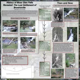
History of Moss Glen Falls Revealed: The Lost Settlement of Brownsville Then and Now 1830’s-1950’s Brownsville: Settlement & Industry A Brief History of Brownsville amidst Moss Glen Falls: Timeline 1850’s -Several Farms in area -Starch Factory at base of falls -School House -Logging Roads to left of falls -Two Dams with holding pools -Concrete -Log -Two Sawmills (1 upstream, 1 downstream of falls) Lydia Smith & Jessica Kuonen Moss Glen Falls is a popular summer spot for sightseeing and swimming. Upon finding historic pictures of the falls with a penstock we wondered what anthropomorphic changes had occurred and what effects these changes had on the bedrock channel. We found that the penstock provided power for several sawmills and a starch mill for the small settlement of Brownsville which was centered around the falls in the late 1800’s. Human Impact of the Channel Present day photo of where starch factory was located. A dam with a penstock that provided hydro power for the starch factory located below the falls (to the right). Downstream: Remainder of log dam Pool above Falls: Evidence of channel widening by blasting 1889-1899 -Starch Factory closed -Large Mill Pond above falls from dam that provided power to a steam sawmill -below the falls was another dam and sawmill of which the foundation still exists The perseverance of the townspeople and the drive for mill power led to several attempts at capturing the most energy from the falls. At times, up to four dams were located within close proximity to the falls supplying energy to multiple industries. The present day photo (and site) show minimal evidence of the roofed structure (above) and the penstock present in the historic photo. Mill-pond sediment below falls, also located in several pools behind pre-existing dams Notches in bedrock remain where dams were constructed Moss Glen Falls Data Channel Type: Bedrock Gorge with alluvium sediments up and downstream of falls, lots of pools and riffles Sediment Type: sand, rounded cobbles and boulders, differs with proximity to falls Discharge: Q=2.9 m3/s, V=1.26 m/s Manning’s n: n = .037 - minor stream GPS: 0688880 N 4928230 E 1900-1950’s -Early 1900’s - area above falls was cleared -Flood of 1927 accounts claim “havoc” in Brownsville -Early 1930’s - becomes tourist mecca -1950’s- glory days of Brownsville are over as economy of the area depresses View of penstock from downstream with present-day photo of same location. Note differences in channel composition and discharge. The penstock was connected to the sawmill downstream to which the foundation is still present (left). Channel Dimensions (downstream of falls)