Understanding Landscape Fragmentation: Insights from FRAGSTATS Metrics
This overview highlights the impact of habitat fragmentation on wildlife populations due to settlement patterns, focusing on the FRAGSTATS software developed by Kevin McGarigal and Barbara Marks. FRAGSTATS provides crucial landscape metrics to analyze spatial patterns in ecological systems. Supported data formats include ArcGRID, while various metrics such as patch density, area, edge, shape, and diversity are utilized to evaluate landscapes. This knowledge is vital for conserving and managing wildlife habitats effectively.

Understanding Landscape Fragmentation: Insights from FRAGSTATS Metrics
E N D
Presentation Transcript
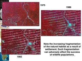
1975 1986 1992 Note the increasing fragmentation of the natural habitat as a result of settlement. Such fragmentation can adversely affect the success of wildlife populations.
FragStats http://www.umass.edu/landeco/research/fragstats/fragstats.html
FRAGSTATS Overview • Derives a set of useful landscape metrics • Public domain code developed by Kevin McGarigal and Barbara Marks under U.S.F.S. funding
Situation • FragStats only supporting 4.x from now on • There tutorial data is in ArcGRID format • Following FragStats instructions on adding support for ArcGRIDs results in: • Only other formats supported are ASCII GRID and binary (neither appear to work)
FRAGSTATS Fundamentals • PATCH… individual parcel (Polygon) A single homogeneous landscape unit with consistent vegetation characteristics, e.g. dominant species, avg. tree height, horizontal density ,etc. A single Mixed Wood polygon (stand) CLASS… sets of similar parcels LANDSCAPE… all parcels within an area
FRAGSTATS Fundamentals PATCH… individual parcel (Polygon) • CLASS… sets of similar parcels All Mixed Wood polygons (stands) LANDSCAPE… all parcels within an area
FRAGSTATS Fundamentals PATCH… individual parcel (Polygon) CLASS… sets of similar parcels • LANDSCAPE… all parcels within an area “of interacting ecosystems” e.g., all polygons within a given geographic area (landscape mosaic)
FRAGSTATS Output Metrics • Area Metrics (6), • Patch Density, Size and Variability Metrics (5), • Edge Metrics (8), • Shape Metrics (8), • Core Area Metrics (15), • Nearest Neighbor Metrics (6), • Diversity Metrics (9), • Contagion and Interspersion Metrics (2) • …59 individual indices (US Forest Service 1995 Report PNW-GTR-351)