Easy Ways to Remember U.S. States and Geography Concepts
This comprehensive geography review offers creative mnemonic devices to help students memorize U.S. states and key geographical features. From states like Utah, Colorado, and Arizona to vital rivers and mountain ranges such as the Rocky Mountains and the Mississippi River, this guide is designed to make learning both fun and effective. With memorable phrases like "Never Sleep Near Kevin's Old Tennis Shoes" for the Dakotas and "Sally's Mom Hates Eating Olives" for notable mountains, students will find this review engaging and informative. Perfect for exam preparation!


Easy Ways to Remember U.S. States and Geography Concepts
E N D
Presentation Transcript
Geography Final Review Student Made
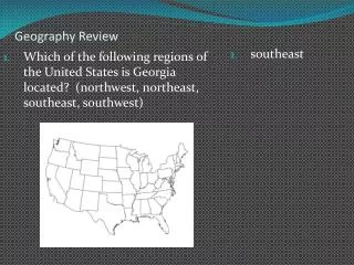
Easy Ways to Remember States U tah C olorado A rizona New Mexico Wyoming WHYoming ?????? C=California O= Oregon W= Washington NeVada
Easy Ways to Remember States Continued North Dakota South Dakota Nebraska Kansas Oklahoma Texas Never Sleep Near Kevin's Old Tennis Shoes
Easy Ways to Remember States Continued Minnesota Iowa Missouri Arkansas Louisiana Many Sodas In Missouri Are Luscious
Easy Way to Remember Stated Continued Mississippi Alabama Georgia Kentucky (fried chicken) Tennessee (on a plate) M A G Vermont & New Hampshire K T
Physiographical Features The Great 5 Lakes H uron O ntario M ichigan E rie S uperior S uperior M ichigan H uron E rie O ntario Mt. McKinley in Alaska part of Brooks Range. Mt. Whitney in California part of the Sierra Nevada's. Sally's Mom Hates Eating Olives
Physiographical Features Continued Mountain Ranges ~ Rocky Mountains is the mountain range west of the Great Plains. ~ Appalachian Mountains are the main chain that runs through the east. ~Sierra Nevada Range separates California and Nevada. ~ The Cascade Range is the tallest range in Washington and Oregon. ~ The Coastal Range runs along California’s Coastline. ~From Brooks Range in Alaska you can see the North Pole. Plains ~The Great Plains are between the Rocky Mtns. And the Mississippi River. ~The Great Plains are also known are the Great American Desert. ~The Great Basin covers most of Nevada and are surrounded by mountains. ~The Coastal Plain is the Flatland that is on the Coastline of the Gulf of Mexico. ~The Coastal Plains extend from the Chesapeake Bay to the east of Florida. ~ Central Valley lies between the Sierra Nevada's and the Coastal Range.
Physiographical Features Continued Bays & Gulfs ~ The Gulf of Mexico is west of Florida and is an extension of the Atlantic Ocean. ~Chesapeake Bay is located east of our nations capital.~ The San Francisco Bay is the largest bay in California. Rivers ~The Hudson River empties into the New York Harbor. ~The Mississippi River is the largest river by volume in the U.S. ~The Ohio River forms a border between Kentucky and Indiana. ~The Missouri River forms a border between Iowa and Nebraska. ~The Colorado River flows through the Grand Canyon. ~The Rio Grande forms between Mexico and the U.S. ~The St. Lawrence River runs east from Lake Ontario to the Atlantic Ocean. ~The Columbia River forms a border between Washington and Oregon.
Latitude and Longitude ~Latitude Lines run east and west but measure north and south ~Longitude lines run north and south but measure east and west ~ The equator is a latitude line that is 0 degrees. ~ Latitude lines are parallel and the same distance apart ~ Tropic of Cancer and Capricorn are Latitude lines at 23.5 degrees ~ Latitude lines are longest at the equator and decrease in size as the measure towards the north and south poles. ~ The prime meridian is a longitude line at 0 degrees ~ Prime Meridian runs through Greenwich England. ~International Dateline is the 0 degree line on the other side ~Longitude lines are also known as meridians ~Longitude lines meet at the north and south poles ~Longitude lines stay the same length
Flat Map Vs. Sphere ~ A Sphere is more accurate then a Flat Map ~A Flat Map is more distorted further away from the equator
Compass Rose ~The Cardinal Points are N,S,E,W ~ The Intermediate Points are NW,NE, SW,SE Hemispheres: