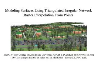
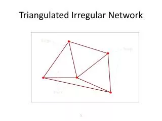
Triangulated Irregular Network
Triangulated Irregular Network. Edge. Node. Face. 3D Structure of a TIN. Real TIN in 3D!. TIN with Surface Features. Classroom. UT Football Stadium. Waller Creek. A Portion of the TIN. Input Data for this Portion. Mass Points. Soft Breaklines. Hard Breaklines.

Triangulated Irregular Network
E N D
Presentation Transcript
Triangulated Irregular Network Edge Node Face
TIN with Surface Features Classroom UT Football Stadium Waller Creek
Input Data for this Portion Mass Points Soft Breaklines Hard Breaklines
TIN Surface Model Waller Creek Street and Bridge
Direction of Flow Channel Cross-Section Channel and Cross-Section
HEC GeoRAS • A set of ArcGIS tools for processing of geospatial data for • Export of geometry HEC-RAS • Import of HEC-RAS output for display in GIS • Available from HEC at http://www.hec.usace.army.mil/software/hec-ras/hec-georas.html • An old tutorial on using GeoRAS for Waller Creek with ArcView 3.x is available at: http://www.crwr.utexas.edu/gis/gishydro01/Class/exercises/georas.html
Hydraulic Modeling with Geo-RAS GIS data HEC-RAS Geometry HEC-RAS Flood Profiles Flood display in GIS
Hydraulic Modeling with HEC-RAS • Cross-section extracted • from the TIN. • RAS stream geometry.
Hydraulic Modeling with HEC-RAS • Resulting water • elevations.
Floodplain Mapping • Floodplain for • 500 cfs.
Floodplain Mapping • 2-D floodplain • animation • (500 – 5,000 cfs).
Floodplain Mapping • 3-D floodplain • animation.