Enhancing the National Hydrography Dataset for Water Resource Management in West Virginia
170 likes | 280 Vues
This seminar discusses the National Hydrography Dataset (NHD) and its significance in GIS-based water resources analysis in West Virginia. It covers the NHD's structure, applications, and enhancements, including the addition of state stream codes and the derivation of watershed data. Key examples include its use in ecological assessments, fisheries management, and water quality modeling. The NHD serves as a foundational tool, integrating various datasets to improve landscape analysis and support informed decision-making for water resource management.

Enhancing the National Hydrography Dataset for Water Resource Management in West Virginia
E N D
Presentation Transcript
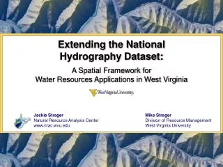
Extending the National Hydrography Dataset: A Spatial Framework for Water Resources Applications in West Virginia Jackie Strager Natural Resource Analysis Center www.nrac.wvu.edu Mike Strager Division of Resource Management West Virginia University
Introduction • NHD as a foundation for water resources analysis in GIS • NHD overview • Applications • Adding information to NHD • Deriving additional data using NHD framework • Additional related datasets
What is the NHD? • National Hydrography Dataset • Nationwide, consistent format • WV NHD includes: • Medium resolution (1:100,000) • High resolution (1:24,000) • Local resolution pilots (1:4,800) * Seminar Thursday AM
Properties of the NHD Route measures 2 miles 1 mile • NHD includes: • Surface water features • Flow model • Route measure model • Extending NHD and related applications: • Adding info: WV state stream codes and names • Derived data: WV segment-level watersheds • Additional data: NHD Plus Direction of flow
Extending the NHD • Extending NHD and related applications: • Adding info: WV state stream codes and names • Derived data: WV segment-level watersheds • Additional data: NHD Plus • Used in applied projects in fisheries, ecological assessments
1. Adding info to the NHD • NHD 1:24,000 flowlines • Added WV state stream names and codes (WVDEP) • Unique reference for each stream as a whole • References state data to streams • All streams have some name, even if NHD has none • Unnamed tributaries named using reference point (River Mile) along mainstem stream
1. Applications: Adding info to the NHD • Mapping WV trout streams • Applying WV codes & NHD stream measures:
1. Applications: Adding info to the NHD • Stream segmenting for crayfish project • 150m segments needed • Statewide, on stream by stream basis Strader Run, South Branch Potomac
2. Derived data from NHD • Segment-level watersheds for WV • Statewide coverage for 24K NHD • Custom tools developed: • Determine upstream watersheds • Cumulatively total watershed variables • Determine distance to upstream features
2. Applications: Derived data • Big sandy examples Upper Little Sandy Cumulative area upstream of abandoned minelands Upper Little Sandy Distance to closest upstream mine permit
2. Applications: Derived data • Application: Mining intensity index (0-100) • Lower Cheat river basin • Function of: • Cumulative area of mining features • Cumulative area of coal seam outcrops
2. Applications: Derived data • WVU Research • Fisheries Management • Mussel distribution modeling (Alison Mynsberge) • Dr. Todd Petty and students • Brook trout conservation (Jason Clingerman) • Landscape-water quality interactions (Eric Merriam) • Temperature model, swim distances (Roy Martin) • Water Quality • Water Research Institute, WVU • Mass-balance water quality model using linked watersheds, cumulative analysis
3. Additional NHD related data: NHD Plus • NHD Plus • Available nationwide at 1:100,000 scale • Includes: • New value-added attributes for streams • Thinner code • Flow • Stream order • Path length • Segment level catchments • Modeling tools (software)
3. Applications: NHD Plus Catchments
Summary • Described in this talk: • NHD, plus WV stream codes, route measures • WV segment-level watersheds • NHD Plus • Allows us to assess the influence of landscape factors on instream water quality and biota • Datasets used in current ecological studies in Cheat, Tygart, Ohio River basins • NHD and segment-based watershed data models provide useful framework for many present and future activities
Related links • Jackie Strager • Natural Resource Analysis Center • West Virginia University • jmstrager@mail.wvu.edu • (304) 293-4832 ext.4455 http://nhd.usgs.gov/ http://www.horizon-systems.com/NHDPlus/