Download
1 / 55
550 likes | 827 Vues
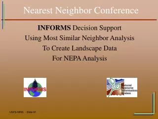
Nearest Neighbor Conference. INFORMS Decision Support Using Most Similar Neighbor Analysis To Create Landscape Data For NEPA Analysis. Overview. Create a current wall to wall vegetation layer. Grow stand data to current and future year conditions.

E N D
Nearest Neighbor Conference INFORMS Decision Support Using Most Similar Neighbor Analysis To Create Landscape Data For NEPA Analysis
Overview • Create a current wall to wall vegetation layer. • Grow stand data to current and future year conditions. • Create alternatives and model vegetation treatments (i.e. thinning) for NEPA analysis and impacts evaluation. • Run models to evaluate and compare alternatives.
Included Applications NRIS INFORMS A project-level landscape analysis framework. NRIS FSVeg Forest Service Field-Sampled Vegetation database. Forest Vegetation Simulator (FVS) An individual-tree, distance-independent growth and yield model. Most Similar Neighbor (MSN) A powerful application used to impute available ground-based inventory data to non-inventoried units. Stand Visualization System (SVS) Visualize time-step data on a stand by stand basis. Fire Area Simulator (FARSITE) A fire spread simulator.
Data Requirements • FSVeg stand exam data • Local stand coverage (which relates to the data in the FSVeg database) • Non-forested survey data (i.e. rangeland data). • Forest FVS Variant Files • Most Similar Neighbor analysis • DEM derived grids for Slope (in radians), Slope Catchment Area, Insulation and Duration. • Landsat grids for reflectance values for bands 1, 2, 3, 4, 5 and 7.
NEPA Analysis Process FSVeg Data Sampled Vegetation and Fuels Data FVS/FFE Most Similar Neighbor (MSN) DEM & Landsat Wall-to-Wall Current Vegetation and Fuels Data Legend: Yellow = Inputs Blue = Outputs Green = Models Treatment Alternative FVS/FFE Wall-to-Wall Future Years Vegetation and Fuels Data (No Action and Alternative) Fire Area Simulator (FARSITE) Stand Visualization System (SVS)
Process Overview • Running MSN • Creating the No Action Alternative • Alternative Building • Evaluating Alternative Impacts • INFORMS Prescription Definition • Summary
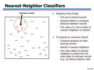
How is Most Similar Neighbor Used? • The MSN application is used to impute available ground-based inventory data to non-inventoried units. • The MSN method uses available data from the ground-based sample units and globally available data measured on all sample units to guide the imputation. • Examples of global information for all sample units include topographic data and satellite imagery. • Landscape of vegetation data is available for analysis based on imputations from the MSN process.
MSN Calibration • MSN analysis command files are prepared and tested for each FVS variant. Calibration (selection of variables) is the most critical part of Most Similar Neighbor analysis. • Variables contained in the command files are carefully selected in cooperation with the researchers who developed the Most Similar Neighbor application and methods. • Once calibrated, there is a standardized methodology for each FVS variant.
MSN Calibration Variables Calibration is the process of finding the correct combination of global and sampled data for each FVS variant. Global Data = Data that is available for all polygons (i.e. slope, aspect, Landsat, etc.). Sampled Data = Data that is available for sampled polygons (i.e. stand exams) or other vegetation sampling (i.e. range data, fuels plots). Examples include Basal Area, Trees per Acre, QMD, Volumes, etc.
Where MSN is calibrated by FVS Variant Completed Not Done Yet
MSN Vegetation Grouping • Most Similar Neighbor analysis is run separately on Forested and Non-Forested polygons. • Vegetation polygons must be divided into three groups by the local GIS shop by adding an attribute into the local stands layer: • Forested Vegetation (FV) • Non-Forested Vegetation (NF) • Non-Vegetated (NV)
Preparing Global and Sampled Data in INFORMS • Global Data Preparation Tool: Summarizes data from the DEM and Landsat Scene into an input format for Most Similar Neighbor analysis. • Sampled Data Preparation Tool for Forested Polygons: Grows all stand data forward to the year of the Landsat scene to calibrate stand data to the current condition using FVS. • Sampled Data Preparation Tool for Non-Forested Polygons: Data is currently used to impute Fuel Models only.Work is being done in conjunction with USDA Risk Management agency to develop methods to calibrate MSN to produce detailed data for non-forested vegetation.
Running MSN • MSN is run as a tool in INFORMS once all of the data is prepared. • ‘Go/no go’ statistics are presented when MSN is run. This advises the user whether the MSN run should be used for further analysis. • Statistics are also produced for specific vegetation attributes resulting from the MSN run. (e.g. basal area, stand height, etc.)
MSN Forest Vegetation Quality Gray= Reference (sampled) stands Green= OK Quality (Imputed) Red= Poor Quality (Imputed) Yellow= Non-Veg (rocks, lakes, etc.) Brown= Non-Forest (grass, shrubs, etc.)
MSN Report for Forested Vegetation Produced with each MSN run is the MSN Report. It is a text file summarizing the key elements of the MSN run. These are the attributes in the vegetation map.
MSN Results • The MSN results are stored in a copy of the NRIS FSVeg database table NRV_MSN_FOR_USE. • This table contains a list of links of un-sampled stand polygons pointing them to their ‘most similar neighbor’ with sampled data. • This process allows INFORMS tools to use imputed data without loading hypothetical data into the corporate FSVeg stand and tree tables.
Reference Stands NRV_MSN_FOR_USE Reference Stands • Stands with sampled data. • Note: FOR_GIS_LINK and USE1_GIS_LINK are the same.
Imputed Stands NRV_MSN_FOR_USE Imputed Stands • Stands that have not been sampled. • Note: FOR_GIS_LINK and USE1_GIS_LINK are different. • USE1_GIS_LINK is the best match.
Imputed MSN Stands Red= MSN Imputed Stands Blue= FSVeg Stand Exams Yellow= No Data
How does MSN help the Forest Service? • Provides a method to easily maintain and annually update a current vegetation layer. • Provides a current wall-to-wall vegetation layer containing base-scale attributes. • Allows a site to grow the current vegetation layer forward into the future using FVS for analysis of future conditions. Some examples are: • Current and Future Fire Regime Condition Class (FRCC) • Current and Future Vegetative Structural Stage (VSS) • Current and Future individual stand burning conditions • Allows for modeling of treatments to the vegetation layer for NEPA analysis and impacts evaluation.
Vegetation Layer The results from FVS and MSN are used to generate current and future vegetation layers for each decade in the simulation. Fuel Model – Same Year With MSN Without MSN
Base FVS Vegetation Layer A wall-to-wall base vegetation layer is built for each decade in the simulation. This layer contains information such as basal area, stand height, qmd, canopy cover, overstory dbh and more.
Fuels Analysis Data • The results from FVS and MSN are used to generate current and future fuels data layers for each decade in the simulation. • Attributes in the layers include fuel model, crown bulk density, torching index, etc. • These data layers can be used to compare fire behavior changes over time. This is done in two ways: • Data required for FARSITE is prepared for each decade. • A Fire Intensity Map is created for each decade.
MSN Accuracy Assessment • Work is being done to produce a standard accuracy assessment methodology for MSN as used in INFORMS. Cooperators are: • Natural Resource Information System (NRIS) • Rocky Mountain Research Station (RMRS) • Remote Sensing Applications Center (RSAC) • An accuracy assessment was performed on the Lincoln National Forest (Region 3) in 2005. The above-mentioned parties will produce a report in 2006. • Once this approach is finalized, it should provide a standard by which to evaluate base vegetation layer maps.
2. Creating the No Action Alternative
Creating No Action Alternatives Basal Area No Action Plus Disturbance No Action
Crown Fire Initiation Maps 2005 2045
2045 2005 2015 2035 2025
Fire Regime Condition Class (FRCC) • Output 1: Classification of existing vegetation into potential natural vegetation groups (PNVG) if the local site does not have an existing PNVG map. • Output 2: Seral stage classifications. • Report: • Calculation of percent of each seral stage by PNVG within the analysis area. • Calculation of FRCC for each PNVG. • Overall FRCC
FRCC - PNVG Potential Natural Vegetation Groups (PNVG)
FRCC - Seral Class 2045 2005
Alternative Building in INFORMS • Vegetative future conditions are created by defining alternatives and applying vegetative treatment prescriptions. • There are three methods for applying prescriptions to a stand or a portion of a stand. A tool is available to split a stand. • If MSN analysis is used, prescriptions can be applied to imputed stands (stands which do not have a stand exam in FSVeg). • Treatments are applied through FVS keyword files. This changes future condition vegetative values.
Evaluating Impacts for Alternatives • The results of the prescription treatments from FVS are used to generate current and future vegetation data for each decade in the simulation. • The ‘treated’ alternative layers contain treated and untreated stands for the complete analysis area. • This allows for comparison of effects between the no action and treatment alternatives at different time steps.
Examples – Alternative Evaluation • Current/Future year comparisons: • Crown Fire Initiation • FARSITE • Fire Regime Condition Class (FRCC) • Vegetation Structural Stage (VSS) (Region Specific)
Basal Area Before and After Treatment – Same Year Burn Simulation Treatment No Treatment
Risk Map Before and After Treatment – Same Year No Action Alternative A
No Action Alternative A • No Action – 457ha burned After Treatment – 391ha burned FARSITE Before and After Treatment – Same Year
2045 2005 Crown Fire Initiation No Action Treatment
INFORMS Prescriptions • Prescriptions, as used in INFORMS, are a collection of FVS keyword files which can be assigned to stands. • INFORMS uses FVS to modify the vegetative landscape to represent alternative future conditions. • Sources of FVS keyword files: • Many regions are creating standard keyword files • Forest Health is creating keyword files for modeling pest impacts • Local FVS users can create their own keyword files
Stand Visualization System (SVS) • SVS visually demonstrates the effects of treatments. • Better ID team and public communication of prescription treatment results.
Stand Visualization SystemWildfire Example Wildfire in 2035
Stand Visualization System Underburn Now, Wildfire in 2035
Stand Visualization System Thin Now, Wildfire in 2035