Download
1 / 40
540 likes | 1.97k Vues
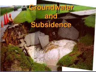
Subsidence and Sinkholes in Southwest Florida. Causes of Subsidence, Exploratory Methods, and Technological Solutions. Sandy Nettles, PG, N.S. Nettles & Associates, Inc. 12/5/06. Major Confirmed Sinkhole in Florida/Pasco County. Causes of Subsidence. Improperly Compacted Fill (rare)

E N D
Subsidence and Sinkholes in Southwest Florida Causes of Subsidence, Exploratory Methods, and Technological Solutions Sandy Nettles, PG, N.S. Nettles & Associates, Inc. 12/5/06
Causes of Subsidence • Improperly Compacted Fill • (rare) • Buried Construction or LandClearing Debris • (uncommon but more prevalent in older neighborhoods) • Buried Organics or Peat Deposits • (rare except around relic sinkholes) • Soil Creep or Slump • (rare) • Clay Shrink/Swell • Rare in central Florida • Sinkholes • Very Common
Improperly Compacted Fill • Typically occurs within first 3 to 4 months of construction • Generally results in hairline cracks • Does not continue or re-activate after initial settlement • Weight of house compacts the fill soil
Buried Debris • Sand gradually migrates into void spaces around debris, resulting in subsidence at ground surface • Can cause massive damage • May occur many years after construction
Buried Organics/Peat Deposits • Decomposition, compression, and consolidation of soft, loose organic material • Requires thick accumulations, degree of subsidence is related to size of deposits • System will stabilize to a specific load, increasing load will reactivate subsidence • Peats generally develop in slowly subsiding basins in FL (sinkholes) • Many organics deposits are “sapric,” meaning they have already undergone as much decomposition as can possibly occur (very fine-grained) • Decomposition of tree stumps generally will only affect small areas, and is not typically a cause of damage to foundation unless multiple stumps are present
Soil Creep or Slump • Requires steep topographic slope • Generally also needs shallow confining layer (clay or hardpan) to provide a slip face • Generates crescent-shaped depressions with small berms on down-slope side • Damage can be minor to severe
Shrink/Swell Clay • Requires smectite-type clays with high potassium concentrations (volcanic origin) • Florida’s clays typically have a lower shrink/swell potential • Need to be exposed at land surface to exhibit dehydration, rehydration (shrink, swell) • If 1 to 3 feet of sand overlies clay unit, shrink/swell potential is greatly lowered • Concentration of clay must be very high • Damage can be severe and process can be active for long periods • Relatively rare occurrence in West-Central Florida
Sinkholes Image from the Southwest Florida Water Management District Online
Types of Sinkholes • Collapse • Fast moving, devastating damage • Cover Collapse • Cover Subsidence • Solution • Slow Moving, long-term dormancy & reactivation may occur before visible damage
Cover Collapse Sinkholes Image from http://www.uky.edu/KGS/water/general/karst/ksinkdiagram.htm
Cover Subsidence Sinkholes Image from http://waterquality.ifas.ufl.edu/Water%20primer/Underground%20water/Sinkholes.htm
Solution Sinkhole Image from http://www.uwsp.edu/geo/faculty/ozsvath/images/solution_sinkhole.htm
Sinkholes in Pasco County & Surrounding Area • All types are present • Most common are cover collapse, cover subsidence, and solution • Re-activation of relic sinkholes is most common form of sinkhole damage • Stimulated by: • Construction dewatering activities • Well pumping • Site loading (house construction) • Rain events, storm surge, flooding • Earthquakes • Explosions • Sinkholes lead to settling sand and differential settlement
Historical Aerials and Topo Maps Can Help! • What to look for: • Circular or elliptical wetlands, ponds, lakes • Depressions with closed contours • Linear wetland features • Cypress domes • Cypress sloughs • Creeks, rivers, etc. • County should preserve aerial photograph records • University of Florida website provides extensive historical aerial database http://web.uflib.ufl.edu/digital/collections/FLAP/Index.htm
1941 Historical Aerials of General Regions in Western Pasco County
Patricia Estates Patricia Estates in Dunedin, FL (1941, Pre-Development)
Location of Confirmed Sinkhole Residences & Top of Limestone Map for Patricia Estates Top of Competent Limestone Confirmed Sinkholes Denoted in Orange
Geophysical and Geotechnical Surveys • Multi-Electrode Electrical Resistivity (MER) • Cone Penetration Testing (CPT) • Ground Penetrating Radar (GPR) Mapping • Seismic Refraction and Multi-Channel Analysis of Surface Waves (MASW) • Gravity Mapping • Standard Penetration Test (SPT) borings • Miscellaneous Testing
Multi-Electrode Electrical Resistivity (MER) Image from www.agiusa.com
Penetrate and map through virtually any material Records to great depths (250+ feet) Records changes in sediment type (sand, silty sand, clayey sand, limestone, etc.) Maps voids, fracture zones, ravel zones Continuous geologic profiles Non-invasive, cost effective, rapid results Can record stratigraphy beneath structures Can generate 3-Dimensional Maps Ground-truthing by CPT/SPT needed in new environments Occasional interference from nearby electrical sources or other objects Requires long, straight line to record deep data More labor intensive, higher cost than GPR or other electrical methods MER – Pros MER - Cons
High resolution, continuous density data sets (every 0.1 feet) Differentiates sediment types Multiple types of data (relative density, N-Values, pore pressure, friction, point pressure) Automated system eliminates human error Rapid process, cost effective Best method to definitively confirm sinkhole activity No physical sample of soil is obtained Site access can be limited due to drill rig size Dense strata can prevent further penetration (i.e. bedrock, dense sand/shell) Few ASTM Standards 20 ton rigs available CPT – pros CPT - cons
Ground Penetrating Radar (GPR) Image from www.gprcentral.com
One-man operation Rapid mapping capability Low cost Results produced in real time Effective in mapping buried utilities Can map inside structures easily (depth of penetration may be limited) Data penetration limited by multiple variables (clay content, mineralized soils, organic deposits, mineralized water), Radar will not penetrate Cannot differentiate between sediment types Numerous false positives Not effective in locating sinkhole features in most of west central Florida Works best in clean, deep dry sand and fresh groundwater GPR – Pros GPR - Cons
GPR Survey Data Examples Rock surface under clean sand Buried Utilities Image from rhdservices.com Image from www.earth.boisestate.edu
Deeper penetration than MER for same transect length Rapid data collection Accurately records sediment interfaces (sand/clay/limestone) Map caverns and relic sinkholes Can be used inside buildings, map beneath structures Used to provide quantitative information for excavation (assess necessary types of equipment to excavate specific materials) Non-invasive Requires relatively long, straight transects Relatively lengthy data processing (but can be done in field) Will not differentiate sediment types Surrounding noise can cause interference (AC units, cars, etc.) MASW – Pros MASW - Cons
MASW Data & Velocity Profiles 1-D Velocity Profile 2-D Cross Section
Gravity Mapping Example of Large-Scale Gravity Mapping – Continental Shelf Regions Small Gravimeter
Generate data in tight locations where MER, seismic cannot access Penetrate to great depths Effective in mapping buried karst features Very labor intensive Requires surveyed locations Cannot differentiate between sediment types Maps only gross features Expensive and time consuming to generate data Rarely used Gravity Mapping Pros Cons
Standard Penetration Tests (SPT) Drill Rig Split-Spoon Sample Images from http://www.ce.siue.edu/CIVIL/class/ce354/supplement/exploration/Sampling.htm
Penetrate through all types of material Provides physical sample of subsurface soils/rock Can define sinkhole conditions Records “loss of circulation” zones (highly porous) Large number of drill rigs available in US Low resolution density data sets (5-foot intervals) Slow and expensive, not cost effective Human error Site access limitations Potential damage to property May initiate sinkhole collapse SPT – Pros SPT - Cons
Miscellaneous Testing • Hand auger soil sampling • Jet probes (depth to clay, rock, buried debris) • Sieve analysis of sediment samples (% sand/silt, clay) • Clay content % analysis (hydrometer) • Clay moisture content variation over time • Organic content analysis • Water table elevation determination • Land surface topography - slope
Sinkhole Remediation – Undeveloped Sites • Move proposed structure to a different site • Move proposed structure to different location on original site, build foundation as post-tension mat • Design foundation to span sinkhole feature • Drill piles 10 feet into competent rock • Beam structures between piles to support post-tension mat • Post-tension mat construction
Sinkhole Remediation – Undeveloped Sites, Contd. • Pilings • 10 feet in competent rock • Concrete cast in-place are ideal, wood only in certain soil types • Deep pilings depend on lateral support • Piles must be placed on grid beneath entire structure • Grouting • Effective only when voids have been accurately defined by MER, CPT • Stabilize void with flowable fill • Very expensive, sometimes only temporary fix as water can re-establish flow around grout, initiate new sinkhole activity • Dynamic Compaction • Effective in consolidating ravel zones/voids, does not cure sinkhole condition • Can create sinkholes in adjacent properties • Quick and cost-effective for consolidating sediments • Post Tension Mat Construction • Least expensive remediation method • Effective in retarding structural damage, movement may still occur • Requires flexible piping for utilities to accommodate lateral migration