Integrating Transit Analysis Zones (TAZs) in Planning Framework for Enhanced Spatial Development
150 likes | 231 Vues
The project aims to incorporate Transit Analysis Zones (TAZs) within Counties using a GIS approach. Funded project starting in late 2008 and early 2009 with staff time included. Research and decisions on TAZ sizes completed; discussions with census bureau on TAZs integration. Applicability of new block group criteria to TAZs considered. Federal guidelines and minimum population requirements for TAZs and tracts followed. Progress reviewed and verified through state and MPO collaboration.

Integrating Transit Analysis Zones (TAZs) in Planning Framework for Enhanced Spatial Development
E N D
Presentation Transcript
Will there will be TAZs? • Developed in late 2008 and early 2009 • All zones would nest within each other and Counties • GIS approach to development • Funded under Consolidated Purchase Make sure to include staff time in Work Program
For 2000 BG Minimum was 300 to 600 people For Tracts the Minimum was 1,500 people
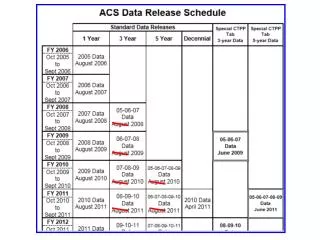
Federal Register Notice www.census.gov/geo/www/psap2010/psapcriteria.html
TAZS Discussions with CB for including TAZs in PSAP software-contracts in place Research on Disclosure Completed--Final Decisions on TAZ sizes PSAP--TAZ Info to States and MPOS--TAZs developed by States and MPOs Verify and Review by CB
Will the NEW Block Group criteria be applied to TAZs? NO YES Should it apply?