Opening 18 Polygon 44
50 likes | 172 Vues
This photo series chronicles the impact of logging and mountain pine beetle activity on forest ecosystems in the Upper Sukunka and Prince George Forest Districts. It highlights the cycle from logging in the 1970s, through wood replanting initiatives in the 1980s, to the substantial mountain pine beetle (MPB) infestations that occurred in 2006. Key images reflect the health decline of young lodgepole pine stands and the ecological changes over decades, documenting both the devastation of natural events and the resilience of forestry management practices.

Opening 18 Polygon 44
E N D
Presentation Transcript
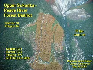
Upper Sukunka - Peace River Forest District Opening 18 Polygon 44 Pl Sw 2101-16 • Logged 1971 • Burned 1974 • Planted 1977 • MPB-Killed in 2006 Photo by Jamie Eason Canfor, Chetwynd May 25, 2007
South of Mackenzie Lakes - Prince George Forest District Young Pl Polygon 186 93G046 Nov.8, 2006 Mostly attacked in 2006 View of Block Approx. 11 Months Later Young Pl Polygon 186 Oct. 18, 2007
Substantial MPB Attack in 2006 Nov. 8, 2006 View of Block Approx. 11 Months Later October 16, 2007
March 9, 2004 MPB activity in young Pl plantations over 3.5 years along Bowron River approx. 10 km north of Hwy. 16 E. A B A = Opening # 54, 75.2 ha (Opening I.D. = 571) Canfor A18165, CP 488 Logged in 1987 Planted in 1989 Manually brushed in 1994 18 year old Pl in 2007 October 4, 2007 A B B = Opening # 20 Logged in 1975 28 year old Pl in 2007
View to the northeast over the Bowron River at km 84.8 of the Bowron F.S. Rd. in July 1986 depicting 93H052-65 of A17778 (P.G. Wood Preserving Ltd.) The effects of clearcutting the spruce beetle outbreak and the impact of a subsequent escaped slash burn (that became the “Bow Fire” in the spring of 1985) and burnt the narrow reserve along the river. R. Hodgkinson - July 1985 Photo GPS location: N 53º 30’ 39” W 121º 38’ 10” Logged 1981-1985 (439 ha) Escaped slash burn 1985 Site Prep. 1985-1987 Planted 1988 (439 ha) Over 21 years later (October 18, 2007) at close to the same viewpoint with mountain pine beetle killed young lodgepole pine. R. Hodgkinson - Oct. 18, 2007