Download
1 / 13
130 likes | 242 Vues
This project evaluates the energy production potential from tidal currents in the United States, aiming to create a comprehensive spatial-temporal assessment. It has established a publicly available national database on tidal stream energy and developed interactive GIS tools for industry users. The project utilizes the Regional Ocean Modeling System (ROMS) for numerical modeling, calibrated with NOAA data, and validated by ORNL. Challenges included accurately modeling the 3-D flow structure and data dissemination. Future research should focus on detailed regional modeling and improved power calculation methods.

E N D
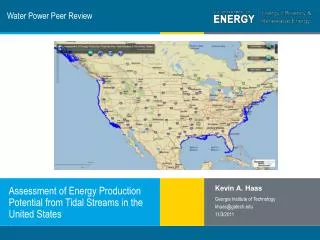
Water Power Peer Review Kevin A. Haas Georgia Institute of Technology khaas@gatech.edu 11/3/2011 Assessment of Energy Production Potential from Tidal Streams in the United States
Purpose, Objectives, & Integration Challenges and knowledge gaps addressed: • Provide a full spatial-temporal assessment of tidal currents for the U.S. coastline • A national database of tidal stream energy potential that is publicly available • Interactive Geographic Information Systems (GIS) tools for users to assess the scale and the nature of tidal stream power Relation to program’s mission and objectives: • Promote development of tidal current energy technology and accelerate the market
Technical Approach Methodology: • Tidal currents are numerically modeled with the Regional Ocean Modeling System (ROMS) • Calibrated with the available measurements from NOAA • Independent validation by ORNL • Create a national database of tidal constituents and descriptive statistics • Build GIS servers to disseminate the data • Provide GIS tools • Compute the total theoretical power
Technical Approach Key issues: • Spatial-temporal distribution Numerical modeling for better spatial coverage Extract tidal constituents for predicting tidal stream velocities
Technical Approach Key issues: • Data accessibility Provide an easy to access, user friendly interface for industry • Facilitate resource investigation Provide basic tools for industry to facilitate preliminary assessment of the tidal stream power resource • Identify resources at a location and generate plots on the fly • Download data for further analysis • Filter for depth, tidal current speed and tidal stream power density • Total available power What is the total available power on a national scale?
Plan, Schedule, & Budget Schedule • Initiation date: 15 September 2008 • Completion date: 31 March 2011 Budget: $469,500 Expended: $469,492.85
Accomplishments and Results Accomplishments: Project completed. Available at http://www.tidalstreampower.gatech.edu/
Accomplishments and Results Goals accomplished: • Provide a full spatial-temporal assessment of tidal currents for the U.S. coastline • A national database of tidal stream energy potential that is publicly available • Interactive Geographic Information Systems (GIS) tools for users to assess the scale and the nature of tidal stream power • Promote development of tidal current energy technology
Challenges to Date Challenges faced: • Resolving the 3-D structure of the flow (i.e. vertical profile) for a project at national scale • Correct assessment of the total available power • Dissemination of data during peak demand Approaches to resolve challenges: • Modeling with Barotropic assumption • Garrett and Cummins (2005) formula used to estimate the total available power • Additional server and separating the services to meet the peak demand
Next Steps Suggestions for future research: • Project is a preliminary assessment of the resources at a national level • More detailed modeling for regions of higher energy, possibly including 3-D structure (i.e. depth variation) • Need for measurement data preferably with durations long enough to derive tidal constituents accurately at energetic locations • Develop more accurate methods for calculating the total power for regions with high energy • Additional geographical information can be integrated to the database