Track Survey Technology
100 likes | 126 Vues
This document is prepared to provide information on Reality IMTu2019s Track Survey Technology including hardware, software, sample scope of work, and how the technology is being used in asset management and signals.

Track Survey Technology
E N D
Presentation Transcript
↓ INQUIRE HOME BLOG TRACK SURVEY TECHNOLOGY BLOG Track Survey Technology 1. INTRODUCTION 1.1. PURPOSE OF THIS DOCUMENT This document is prepared to provide information on Reality IMT’s Track Survey Technology including hardware, software, sample scope of work, and how the technology is being used in asset management and signals.
1.2. INTENDED AUDIENCE This document is intended to help the project team identify areas of interest where track survey technology can be applied to save time, reduce cost and/or improve e?ciency. 1.3. DEFINITIONS, ACRONYMS AND ABBREVIATIONS Acronym or abbreviation De?nition Full motion video synchronized with GPS location based on timestamp. An Image with GPS location embedded in it. Geovideo/Geoimage GIS Geographic Information System. LIDAR Light Identi?cation Detection and Ranging. GNSS Global Navigation Satellite system with Inertial System Inertial Navigation System. Uses a computer, motion sensors (accelerometers) and rotation sensors (gyroscopes) to continuously calculate by dead reckoning the position, the orientation, and the velocity (direction and speed of movement) of a moving object without the need for external reference. INS Real Time Kinematic. A satellite navigation technique used to enhance the precision of position data derived from satellite-based positioning systems RTK POI Point of Interest A cloud-based software platform for Geovideo, geoimages and GIS. OcuMap consists of the following main parts: client application (OcuMap Viewer) and server application (OcuMap backend application). OcuMap 2. TRACK SURVEY TECHNOLOGY COMPONENTS 2.1. HARDWARE
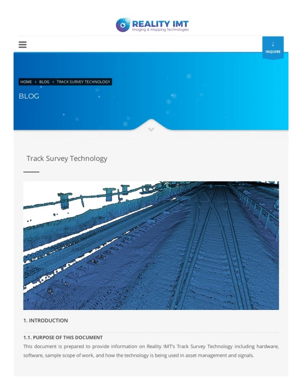
A- 360° Video Camera: An Industrial Grade Panoramic Camera with 30 Megapixels capable of recording full motion video at 14 frames per second. Typically mounted on the roof top of Hyrail to capture right of way conditions. B- Positioning and Navigation System: RTK-GNSS with INS that can log position in real-time with up to + or – 15 cm. C- Video camera: Full motion video camera can be mounted in front of the Hyrail to capture tracks condition. D- Workstation laptop (1 TB+ storage) : Operated by the passenger to trigger video and GOS recording. Collected data is saved onto the workstation for further processing once back in the o?ce. Preview screen allows the operator to see what the camera sees in real-time. E- OPTIONAL: Mobile LiDAR system: Records dimensions and geometry of all objects within the right of way up to 100 meters in diameter.
2.2. SOFTWARE A- Ladybug CapPro: Desktop license for recording full motion video form the camera system. Installed locally onto the Workstation. B- Inertial Explorer license for post processing GNSS/INS Data. Installed locally onto the processing PC at the o?ce. C- Optional: Qincy 9: For post processing LiDAR data D- OcuMap: Web-based software as a service for viewing, geotagging (annotation) and reporting. 3. USE CASE
The system is used to rapidly (45 mph)record ?eld conditions without disrupting the day to day operations of the corridor. It brings the entire site into the o?ce for enhanced decision making. 3.1. ENGINEERING, CONSTRUCTION AND MAINTENANCE Data collected using the system is used in engineering, construction and maintenance to generate and/or verify: – Track Geometry – Horizontal and Vertical Curves – Plan & Pro?le for the entire tracks – Track Charts – Highway Grade Crossing – Ballast and ditch pro?les 3.2. SIGNALS AND OPERATIONS – Identify location and type of assets along the tracks within the Right of Way – Clearance analysis – Monitor changes over time – Condition assessment – FRA Compliance In addition, collected videos and imagery can be used when soliciting bids from contractors on work related to the right of way. 4. SAMPLE SCOPE OF WORK 4.1. SAMPLE 1: AS-BUILT SURVEY SCOPE OF WORK (LIDAR + GEOVIDEO)
Project Name: Track Survey for Central Rail Network Scope of Work: As-built survey to re-create the Railroadcentral subdivision Division Track Charts and Plan and Pro?le drawings in CAD format Survey Requirements: The survey shall establish zero point for stationing, i.e. 0 = 000000+00 and shall include: a. Infrastructure Assetstype, location and dimensions within the ROW b. Curves including spirals and super elevation c. Track elevation, gradient. d. Turnouts location and size, (#11, #13, #20) e. Diamonds location f. Rail weight transitions / compromise joints. g. Track Expansion joints. h. Welded rail sections. i. Insulated joints. j. Bridge type – steel, concreate, wood structure, ID both ends. k. Culvert type – steel, concrete, wood structure, ID both ends. l. Mile post markers. m. Speed signs. n. Signal bungalows, cases, jct. boxes, ?ber jct. boxes. o. Control Points (CP), Intermediate signals (INT), Approach Signals (AS). p. Switch Machines (RH, LH, orientation). q. Derails – Type. r. Road crossings warning systems (level roadway, O/H and U/G). Include name and DOT#. s. Pedestrian Crossings warning systems.
t. Crossing warning system signal types (Cantilever, gates, ?ashing lights). u. Level crossings – Cross bucks. v. Radio towers w. Station platforms, center and each end x. Overhead AC power lines Deliverable: – Sample video here – Plan & Pro?le CAD for 35 miles.Sample here. – Track charts CAD. Sample here – Web-based geovideo- OcuMap. Sample here Work?ow and delivery Schedule: Work performed by Reality IMT included data collection, processing and delivering of CAD ?les with Geovideo for 35 miles of corridor. Activity Duration Coordinate corridor access with client, safety and training with client 1 week Conduct ?eld survey for 35 Miles 1 day Post process collected data 1 week Generate CAD drawings 3 weeks Total Delivery Duration 5 Weeks
OcuMap railroad survey with 360 video camera and GPS Project Name: 360° Visual Corridor Mapping-Asset Documentation and Veri?cation Scope of Work: Collect 360° video with GPS for 400 Miles. Process data and provide a 2-year license to OcuMap viewer. Project Requirements: Lease a 360° camera system for 5 weeks, provide training to one person on how to operate the system, process collected data remotely and provide 2 year access to web-viewer. Deliverable: Web-based geovideo for 400 miles of right of way. Sample here Work?ow and delivery Schedule: Work performed by Reality IMT included leasing the hardware system for 5 weeks, training one person and post processing 400 miles of geovideo data then uploading it to OcuMap. Client chose to lease the system since they were not sure how long it may take to collect video data for 400 miles. This was the most cost-e?ective option. Activity Duration Train one person on how to mount the system and collect data 1 day Login remotely to process collected data on daily basis 4 weeks Upload processed data into OcuMap and provide access to project team Every 24 hrs.
Total Delivery Duration 5 Weeks 5. CASE STUDIES 5.1. RAIL ROAD LIDAR MAPPING HERE 5.2. RIGHT OF WAY IMAGING AND MAPPING. HERE Reality Imaging and Mapping Technologies (Reality IMT Inc.) Categories OcuMap 3D Laser Scan Mobile Mapping General Recent Posts Map Projections Track Survey Technology GIS A Boon To… Use of Advanced Technologies… Showcasing The HARC Facility
SERVICES Commercial As-Builts Hotel As-Built Industrial As-Built Infrastructure As-Builts Museum As-Built O?ce As-Built Rail As-Built Restaurant As-Built Retail As-Built Road & Highway As-Built Sitemap NEWSLETTER SIGNUP By subscribing to our mailing list you will always be update with the latest news from us. your.address@email.com JOIN US We never spam! GET IN TOUCH Tel: +1 713-636-9844 Email: info@realityimt.com Reality IMT 1301 Fannin St. Suite 2440, Houston, TX, 77002 Open in Google Maps GET SOCIAL © 2019 All rights reserved. Reality IMT.