Download
1 / 16
170 likes | 386 Vues
NPP VIIRS Update Presentation to the Global Vegetation Workshop 2009. Dr Robert E Murphy Bonnie Reed NPOESS IPO Data Products Division. VIIRS: Visible Infrared Imager Radiometer Suite. VIIRS will provide operational and research users with:

E N D
NPP VIIRS UpdatePresentation to the Global Vegetation Workshop 2009 Dr Robert E Murphy Bonnie Reed NPOESS IPO Data Products Division
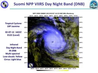
VIIRS: Visible Infrared Imager Radiometer Suite • VIIRS will provide operational and research users with: • Spectral coverage from 412 nm to 12 microns in 22 bands • Imagery at ~375 m nadir resolution in 5 bands (mostly high radiometric quality) • Moderate resolution (~750 m at nadir) (Optimized for radiometry) • Complete global daily coverage with a single sensor • VIIRS virtually identical to MODIS for crucial performance design factors • Dual gain bands replaced some nearby single gain, single purpose bands • Day Night Band in VisNIR • Imaging (high spatial resolution) over full spectral range • Rotating Telescope Assembly replaced Scan Mirror (better stray light control) • Aggregation strategy to provide similar spatial resolution across scan swath • Routine data products • Cloud cover, cloud layers • Cloud and aerosol physical properties • Land & ocean biosphere properties, snow & ice • Sea Surface Temperature, Land & Ice Temperatures • Fire detection
Comparison of MODIS & VIIRS Bands 1.371--1.386 VIIRS Bands I1-I5 are 371 m at Nadir VIIRS Bands M-1-M-16 are 742 m at Nadir MODIS Bands 1-2 are 250 m at Nadir MODIS Bands 3-7 are 500 m at Nadir MODIS Bands 8-36 are 1,000 m at Nadir
VIIRS, MODIS, FY-1C, AVHRR Bandpasses CO2 O2 O3 H2O O2 H2O H2O H2O O2 H2O H2O CO2
VIIRS MODIS Earth-Emitted Spectra Overlaid on Planck Functions
Land Active Fire [ARP] Land Surface Albedo Land Surface Temperature Ice Surface Temperature Sea Ice Characterization Snow Cover/Depth Vegetation Index Surface Type Ocean Sea Surface Temperature Ocean Color/Chlorophyll VIIRS EDRs, IPs, and ARPs EDR-Environmental Data Record | IP-Intermediate Product | ARP-Application Related Product • Imagery & Cloud • Imagery • Cloud Mask [IP] • Cloud Optical Thickness • Cloud Effective Particle Size Parameter • Cloud Top Parameters • Cloud Base Height • Cloud Cover/Layers • Aerosol • Aerosol Optical Thickness • Aerosol Particle Size Parameter • Suspended Matter
Cloud mask is built upon MODIS concepts & experience Common cloud mask for all products Differs from MODIS, which had tailored masks for various products Pixel aggregation scheme reduces pixel growth, provides higher SNR at central region of swath NPP VIIRS has optical cross-talk: aliases some energy from adjacent pixels into a given pixel Extensive testing shows this to be too small to impact the accuracy of the land data products Ocean Color may be a problem, but mitigation strategy is in place Filter will be fixed for F2 Some Noteworthy Items 7
34% more swath for 1.3 km HSI (Imaging bands 1/2 Moderate HSI) 1129 km off-nadir Aggregate 3 in scan 1060 km (530 km off nadir) 1700 km (850 km off nadir) 3000 km (1500 km off nadir) Dual-gain moderate resolution bands to be aggregated on ground 43.6 degrees Better than 1.3 km HorizontalSample Interval (HSI) Well Past 1700km
VIIRS Active Fires ARP • Algorithm Overview • This deliverable Application Related Product (ARP) provides: • Geolocation of the pixels in which active fires are detected, • The sub-pixel average temperature of each active fire, and • The sub-pixel area of each active fire. • Execution Conditions: • Both day and night • Confident Clear pixels • HCS @ Nadir: 0.75 km Issues • Combination of higher resolution pixels and less dynamic range means earlier saturation of fire product compared to MODIS • Pixel aggregation scheme means that a saturated pixel could be averaged with 1 or two unsaturated pixels resulting in erroneous data that is not flagged • Inputs Required • VIIRS Moderate Resolution Reflectances and Brightness Temperatures • M5, M7, M11, M13, M15, M16 • VIIRS Quarterly Surface Types IP • Ancillary Data • Land-Water Mask Improvements to the Fire Product • Dr Ivan Csizlar et al. have been contracted to provide an enhanced fire detection algorithm & evaluate the impact of undetected saturation. • They will run this in the Land PEATE & evaluate its performance pr & post-launch • Provides a test case for moving external (to NGST) algorithms into the operational stream &/or distribution by other means • Expect to have improved dynamic range and better high range calibration for F2 & further improvements to the algorithm • Looking for cost-effective ways to avoid the saturation problem
VIIRS Surface Albedo • Algorithm Overview • Two algorithms will produce two separate albedo data layers for land in the Surface Albedo EDR. The ocean albedo is provide by the Net Heat Flux EDR. • The dark pixel sub-algorithm (DPSA) is based on the MODIS heritage approach although there is no access to the underlying spectral or BRDF information. • The bright pixel sub-algorithm (BPSA) is a TOA regression approach, and was originally intended specifically for bright surfaces • The daily albedo provided is a true or so-called blue-sky albedo, based on instantaneous direct/diffuse lighting conditions and is a broadband quantity only. • Execution Conditions • During daytime • Confident Clear pixels • HCS @ Nadir: 0.75 km Corresponding MODIS Algorithm The MCD43A3 Albedo Product (MODIS/Terra Albedo 16-Day L3 Global 500m SIN Grid) provides both the white-sky and the black-sky spectral gridded albedos (at local solar noon) every 8 days for MODIS bands 1-7 as well as for three broad bands (0.3-0.7µm, 0.7-5.0µm, and 0.3-5.0µm). The grid resolution is 500m. The MCD43A product suite also provides spectral BRDF model parameters and nadir BRDF-adjusted reflectances. • Inputs Required • VIIRS Moderate Resolution Reflectances • M1, M2, M3, M4, M5, M6, M7, M8, M10, M11 • VIIRS Surface Reflectance IP • VIIRS Aerosol Optical Thickness IP • VIIRS Aerosol Model Information IP • VIIRS Snow Cover EDR • VIIRS Ice Concentration IP • VIIRS Gridded Land Albedo IP • Ancillary Data • Total Column Ozone • Total Column Precipitable Water Sample Output Image Not Available
VIIRS Land Surface Temperature • Algorithm Overview • Land surface temperature (LST) is defined as the skin temperature of the uppermost layer of the land surface. • Algorithm has separate day and night non-heritage dual split windows formulations, with a single-split window for back-up/glint conditions. There are unique equations (coefficients) for each surface type. • Execution Conditions • Land pixel • Current and adjacent pixels are “Confident Clear” • No Thin Cirrus or Fire in current pixel (indicated by VCM) • HCS @ Nadir: 0.75 km Corresponding MODIS Algorithm The level-2 MODIS global LST and Emissivity daily data are retrieved as 1-kilometer pixels by the generalized split-window LST algorithm. The MODIS equation uses emissivity as an independent variable. Optimum use of the LST algorithm is gained by separating ranges of atmospheric column water vapor and lower boundary air surface temperature and view zenith angle into tractable sub-ranges. • Inputs Required • VIIRS Moderate Resolution Brightness Temperatures • M12, M13, M15, M16 • VIIRS Surface Type EDR • VIIRS Cloud Mask IP • VIIRS Aerosol Optical Thickness IP • No Ancillary Data Sample Output Image Test Scene 11: 2002118_0215 VIIRS LST (K) VIIRS Chain Test Report – The VIIRS Land Algorithms
VIIRS Surface Type • Algorithm Overview • At the global scale, the surface type algorithm will exploit the spectral and temporal information to separate the 17 IGBP surface types. A Surface Type IP (Global Map) is determined on a quarterly basis using the previous 12 months of multiple spectral bands and indices. The swath EDR algorithm remaps the relevant subset of the IP into swath space, and appends snow, fire and fractional greenness information. It consists of extracting the surface type according to the Quarterly Surface Types IP, Vegetation Index, snow mask and fire mask. • Execution Conditions • Land pixel • During daytime • Confident Clear pixels • HCS @ Nadir: 1 km Corresponding MODIS Algorithm The MODIS Land Cover Classification products contain multiple classification schemes describing land cover properties. The primary land cover scheme identifies 17 classes of land cover defined by the IGBP which include 11 natural vegetation classes, 3 developed land classes, one of which is a mosaic with natural vegetation, permanent snow or ice, barren or sparsely vegetated, and water. The MOD12 classification schemes are multitemporal classes describing land cover properties as observed during the year (12 months of input data). Successive production at quarterly intervals of this annual product creates new land cover maps with increasing accuracies as both classification techniques and the training site database mature. The MODIS product is a gridded product rather than swath-based. • Inputs Required • VIIRS Surface Reflectance IP • VIIRS Active Fires ARR • VIIRS Snow Cover/Depth EDR • VIIRS Quarterly Surface Types IP • No Ancillary Data Sample Output Image Test Scene: 2003299.1835 Surface Type EDR Output VIIRS Chain Test Report – The VIIRS Land Algorithms
VIIRS Vegetation Index Corresponding MODIS Algorithm The MODIS TOC NDVI complements NOAA's Advanced Very High Resolution Radiometer (AVHRR) TOA NDVI products and provides continuity for time series historical applications. MODIS also includes a new EVI that minimizes canopy background variations and maintains sensitivity over dense vegetation conditions. The EVI also uses the blue band to remove residual atmosphere contamination caused by smoke and sub-pixel thin cloud clouds. The MODIS NDVI and EVI products are computed from atmospherically corrected bi-directional surface reflectances that have been masked for water, clouds, heavy aerosols, and cloud shadows. The resolution for this product is 500 m. • Algorithm Overview • Normalized Difference Vegetation Index (Top of the Atmosphere; TOA) uses the traditional NDVI formulation with TOA reflectance inputs. NDVI is most directly related to absorption of photosynthetically active radiation, but is often correlated with biomass or primary productivity. Red spectral measurements are sensitive to the chlorophyll content of vegetation and the near IR to the mesophyll structure of leaves. • This EDR also contains a Top of the Canopy (TOC) Enhanced Vegetation Index (EVI), based on the MODIS equation. • Execution Conditions • Land Pixel • Confident Clear pixels • During daytime • HCS @ Nadir: 0.375 km • Inputs Required • VIIRS Imagery Resolution Reflectances • I1 & I2 • Surface Reflectance IP • No Ancillary Data Sample Output Image Not Available 14 14
Test Status & Issues • We are currently half way through the 93-day Thermal Vacuum (TV or TVAC) testing • This is where most critical performance tests are made including spectral bandpass, linearity, noise, band-to-band registration • Temperature sensitivity of calibrations will be obtained across multiple temperature plateaus • Within orbit temperature variations expected to be below 2K, so expect very little sensitivity to temperature effects • OCB-BB spectral emissivity at all performance plateaus • Polarization will be done in laboratory in post-TVAC phase • Full testing of the Solar Diffuser BRDF not scheduled • Equipment being developed at NIST that may be used as spacecraft level of testing if opportunity arises • Delivery to S/C expected in December 2009 • Supports launch in early 2011 • Suggest you not plan field activities any earlier than mid-2011
Concluding Remarks • In 2011 we will have a worthy successor to MODIS in an afternoon orbit (13:30 crossing time) • Radiometric properties are similar to MODIS • Similar bandpasses, dynamic ranges, quantizations • Geometric properties are enhanced • Higher spatial resolution, reduced pixel growth • Abrupt changes in spatial resolution and noise characteristics may prove “interesting” • Standard products available to all, will be similar to, but not identical with, MODIS products • Capability to make your own products from SDR • Direct broadcast similar to EOS provides full data stream • Working with DRL at NASA GSFC to provide DB users with all necessary algorithms • MODIS veterans heavily involved in leading cal/val effort • Jeff Privette is land lead • Expecting to leverage other activities in US & abroad 16