Download
1 / 16
220 likes | 944 Vues
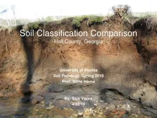
Soil Classification Comparison Hall County, Georgia. University of Florida Soil Pedology, Spring 2010 Prof: Willie Harris By: Sam Vacca 4/22/10. Site Location. Hall County, Georgia Nearest City: Gainesville, Georgia Physiographic Province: Piedmont Annual Precipitation: 54.75 inches

E N D
Soil Classification ComparisonHall County, Georgia University of Florida Soil Pedology, Spring 2010 Prof: Willie Harris By: Sam Vacca 4/22/10
Site Location • Hall County, Georgia • Nearest City: Gainesville, Georgia • Physiographic Province: Piedmont • Annual Precipitation: 54.75 inches • Annual Temperature: 61 degrees F • Predominant Land Use: Agriculture
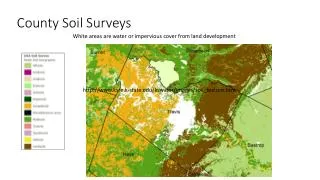
Soil Survey Cc (Pink) – Cartecay and Chewacla Undifferentiated Group (Floodplains; 0 – 2% Slopes; High Water Table) PaE (Blue) – Pacolet Soil Series (Sandy Loam; 15-25% Slopes; Weathered Rock)
Soil Profile 1 Perennial Stream Alluvial System Broad Floodplain Receiving Waterway Degraded Channel Channel Incision Lack of Vegetation Heavy Cattle Use
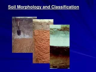
Soil Profile 1 MORPHOLOGY Ap1 -- 0-11 inches; dark grayish brown (10yr 4/2); clay loam; weak sub-angular blocky structure; friable; clear smooth boundary; many roots. Ap2 -- 11-18 inches; dark grayish brown (10yr 4/2); clay loam; moderate sub-angular blocky structure; friable; abrupt smooth boundary. Bw1 -- 18-28 inches; yellowish red (5yr 4/6); silt clay loam; strong platy structure; friable; gradual smooth boundary. Bw2 – 28-39.5 inches; yellowish red (5yr 5/8); loamy sand; structureless massive structure; very friable; distinct smooth boundary. Btg1 – 39.5-67 inches; dark grayish brown (2.5y 4/2); silt loam; strong sub-angular blocky structure; friable; gradual smooth boundary; redoximorphic features (low chroma, Fe concentrations/mottles). Btg2 – 67-70 inches; black (2.5y 2.5/1); silt loam; strong angular blocky structure; friable; abrupt smooth boundary; redoximorphic features. C1 – 70-72 inches; yellowish brown (10yr 5/4); sand; structureless single grain structure; loose; abrupt smooth boundary; line of oxidized Fe above and below. C2 – 72-76+ inches; dark gray (10yr 4/1); sand; structureless single grain structure; loose; gravelly.
Soil Profile 1 Ap1 Bw1 -- 18-28 inches; yellowish red (5yr 4/6); silt clay loam; strong platy structure; friable; gradual smooth boundary. Ap2 Btg1 – 39.5-67 inches; dark grayish brown (2.5y 4/2); silt loam; strong sub-angular blocky structure; friable; gradual smooth boundary; redoximorphic features (low chroma, Fe concentrations/mottles). Bw2 C1 – 70-72 inches; yellowish brown (10yr 5/4); structureless single grain structure; loose; abrupt smooth boundary; line of oxidized Fe above and below. Btg2 C2
Soil Profile 1 • SOIL PROPERTIES • Infiltration Rate: Moderate • Hydraulic Conductivity: Moderate • Available Water: Moderate • Seasonal High Water Table: 100 – <150cm • SOIL INTERPRETATIONS • Dwellings with Basement: Severe • Septic Tank Absorption Fields: Severe • Local Roads and Streets: Moderate • SITE CHARACTERISTICS • Position: Floodplain • Parent Material: Fluvial • Soil Slope: 2-6% • Surface Runoff: Slow • Erosion Potential: Medium • SOIL CLASSIFICATION • Epipedon: Ochric • Subsurface Horizon: Argillic • Order: Ultisol
Soil Profile 2 Perennial Stream Colluvial System Steep Riparian Slopes Tributary to Stream 1 Stable Channel Vegetated Banks No Cattle Use
Soil Profile 2 MORPHOLOGY A -- 0-10 inches; very dark grayish brown (10yr 3/2); loam; weak granular structure; friable; gradual smooth boundary; many roots. Bt1 – 10-36 inches; brown (7.5yr 4/4); clay loam; strong angular blocky structure; firm; diffuse smooth boundary. Bt2 – 36-48 inches; brown (7.5yr 4/3); loamy sand; structureless single grain structure; loose; diffuse smooth boundary; gravelly; C1 – 48-60 inches; brown (7.5yr 4/3); loamy sand; structureless single grain structure; loose; diffuse smooth boundary; very cobbly. C2 – 60-68+ inches; no true matrix color; sandy loam (when crushed); moderate platy structure; firm; clear smooth boundary.
Soil Profile 2 • SOIL PROPERTIES • Infiltration Rate: Moderate • Hydraulic Conductivity: Moderate • Available Water: Moderate • Seasonal High Water Table: 25 – 50cm • SOIL INTERPRETATIONS • Dwellings with Basement: Severe • Septic Tank Absorption Fields: Severe • Local Roads and Streets: Severe • SITE CHARACTERISTICS • Position: Drainageway/Floodplain • Parent Material: Fluvial • Soil Slope: 12-20% • Surface Runoff: Very Rapid • Erosion Potential: Very High • SOIL CLASSIFICATION • Epipedon: Umbric • Subsurface Horizon: Argillic • Order: Ultisol
Soil Profile 1 Soil Comparison Soil Profile 2
Do you ever wonder if perhaps we contribute to the pedological processes out here? What a PEST! Oh, don’t start, Willie!