Soil Erosion Estimation
Soil Erosion Estimation. TSM 352 Land and Water Management Systems. Predicting Soil Loss. Plot scale models (Net erosion, only water erosion) USLE – “Universal ” Soil Loss Equation (AH 537, 1978) MUSLE – Modified USLE (Williams, 1981) RUSLE – Revised USLE (AH 703, 1996)


Soil Erosion Estimation
E N D
Presentation Transcript
Soil Erosion Estimation TSM 352 Land and Water Management Systems
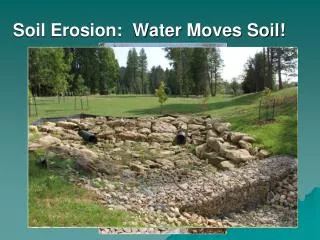
Predicting Soil Loss • Plot scale models (Net erosion, only water erosion) • USLE – “Universal” Soil Loss Equation (AH 537, 1978) • MUSLE – Modified USLE (Williams, 1981) • RUSLE – Revised USLE (AH 703, 1996) • Small watershed scale model (Net erosion) • WEPP – water erosion prediction project More process-oriented, including parameters like biomass, plant height, canopy cover, temporal variations,… • Medium watershed models (Gross erosion) • Radioisotope tracer models - 137Cs, 210Pb, 7Be,…
USLE • Describes erosion as a function of: • Rainfall energy and intensity • Soil properties : erodibility • Topography: slope length and steepness • Soil cover • Conservation practices • Based on 10,000 plot years of data
USLE • A = RK(LS)(C).(P) • A = Estimated soil loss in tons/acre/yr • R = Rainfall erosivity factor, expressed by an average erosion index • K = Soil erodibility factor for specific soil horizon • LS = Topographic factor, • L = Slope length factor: ratio of loss from a given slope length to soil loss from a 72.6 ft length under the same conditions • S = Slope steepness factor: ratio of loss from a 9% under the same conditions • C = Cover management factor: soil loss relative to that from a continuously fallow area • P = Support practice factor: soil loss relative to straight row farming up- and downhill
The USLE Equation: R Factor • Rainfall and runoff erosivity factor (R) • Varies with: • amount of runoff • individual storm precipitation patterns • Characterizes: • The kinetic energy raindrop impact (E) • Maximum 30-min storm intensity (I) • An annual erosivity index for a location is determined by: • Summing up E x I for all storms (n) • The average annual rainfall and runoff erosivity index (R) = (sum of E x I) / n
Susceptibility of soil to erosion • soil loss measured on a series of soils on a unit plot with “worst case” conditions • 72.6 ft long • 9% slope • continuously tilled and fallow • assumed constant all year • Result of unit plot experiments • Nomograph based on: • soil texture / structure / permeability • Most erodible soils with high silt contents • Least erodible soils with high organic matter / strong subsoil structure / high permeabilities Soil Erodibility Factor (K)
Equation to calculate K • K = [2.1x10⁻⁴ (12 – OM) M1.14 + 3.25(S – 2) + 2.5(P – 3)] / 100 • K = Soil erodibility in tons/ac/unit rainfall index • OM = Percent organic matter • M = (%MS + %VFS)(100 - %CL) • MS = percent silt (0.002 – 0.05 mm) • VFS = percent of very fine sand (0.05 – 0.1 mm) • CL = percent clay (< 0.002 mm) • S = Structure index (very fine granular = 1; fine granular = 2; medium or coarse granular = 3; blocky, platy, or massive = 4) • P = Permeability index (rapid = 1; moderate to rapid = 2; moderate = 3; slow to moderate = 4; slow = 5; very slow = 6) Soil Erodibility Factor (K)
Topographic Factor (LS) • Adjusts erosion rates for: • greater erosion on longer / steeper slopes • less erosion on shorter / flatter slopes • when compared to the the USLE standard of: • 9% slope • 72.6 length • Slope length measured from: • top of ridge to the outlet channel • top of ridge to where deposition begins
Cover Management Factor (C) • C = integration of several factors • vegetation cover • crop rotations • length of growing season • land management (tillage practices) • Conventional tillage leaves the surface bare therefore susceptible to erosion • Conservation tillage leaves residue on surface protects the soil from rainfall impact : reduces sheet and rill erosion • residue management • soil surface • binding of plant roots
Types of Tillage • Tillage: the mechanical modification of soil structure • Classified by amount of residue left • Conventional (CT): <15% • Conservation (CM): >30% • No-till (NT) • Alternating (AT) University of Wisconsin, 2012.
Cover Management Factor • For forest, rangeland and other non-agricultural lands C factors based on: • density of vegetation • vegetative residue on the soil surface • For disturbed bare soil C = 1.0
Cover Management Factor No-till planting into corn residue Conservation (mulch) tillage using a chisel plow No-till soybeans growing in wheat stubble
Support Practice Factor (P) • P = Effect of erosion control practices • Practices besides vegetation management • Practices characterized by P are: • strip cropping • contouring • terraces • P varies greatly with slope gradient • For many applications, no erosion control practices are used 1.0 • No experimental data for forests and rangelands
Support Practice (P) Factor • Contouring • Terrace/Diversion, Grassed waterway • Strip systems
Example • Determine the average annual soil loss for the following conditions: location is Champaign, Illinois; soil is Drummer silt clay loam (“the official state soil of Illinois”); l = 300-ft; s = 5%; spring corn-soybean rotation with conservation tillage; and the field has contoured strip cropping conservation practice.
Wind erosion • Important especially in arid regions • Dependent on • Wind speed and exposure • Soil particle- and aggregate sizes • Surface roughness • Tillage • Surface roughness creates turbulence in the surface-near air layer → Under pressure sucks particles in the air • Form of movement: < 0.1 mm → Suspension (“dust storm”) < 1 mm → Saltation (“jumping”) > 1mm → Creep (“rolling”)