Download
1 / 21
250 likes | 473 Vues
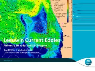
Leeuwin Current Eddies. Altimetry, HF radar and SST imagery. David Griffin & Madeleine Cahill. CSIRO Marine and Atmospheric Research . The Leeuwin Current has the coast on the wrong side.

E N D
Leeuwin Current Eddies Altimetry, HF radar and SST imagery David Griffin & Madeleine Cahill CSIRO Marine and Atmospheric Research
The Leeuwin Current has the coast on the wrong side. Flowing poleward on the west coast of Australia, the Leeuwin is unique in being a downwelling (elevated coastal sea level) boundary current Consequently, the geometry of its instabilities are unlike other boundary currents, The Australian Integrated Marine Observing System (IMOS) has a SeaSonde as well as a WERA HF radar to monitor the Leeuwin off Perth. Lets compare HF radar, altimetry, SST, MODIS chl-a and drifter views of the Leeuwin, particularly the small scale shelf-edge features David Griffin
Conclusions (part 1) J2+J1+C2 yields SLA maps similar to what we are used to. The J1 geodetic orbit has not ruined the data for mesoscale applications. C2 orbit has some advantages to compensate the disadvantages. The HF radar resolves finer-scale processes but is very gappy and has large errors at coverage perimeter. The altimetry, HF radar, drifters and imagery mostly yield consistent pictures of the circulation features. A 20km-radius cyclonic eddy captured a drifter in the ‘armpit’ of Leeuwin. Radar estimates (1m/s) agreed with altimetry (geostrophy) even at this radius. Relative vorticity≈planetary. Leeuwin has 0.1mg/m3chl-a. Offshore cold water (incl. eddy) has even less. Coastal cold water had more, but is not the source for the Leeuwin’s elevated concentration. David Griffin
Highest-ever sea level at Fremantle surge tide 3h period seiche (Molloy, 2001) Leeuwin MSL
modelled sea level, 10-12 June 2012(initialised with altimetry) Rottnest Is Cockburn Sound Leeuwin Sea level anomaly N E 180km
Final conclusion Don’t neglect across-shelf wind forcing. That’s what set this record. De-aliasing of coastal altimetry is harder than deep ocean altimetry. David Griffin
Thank you David Griffin & Madeleine Cahill +61 3 6232 5244 David.Griffin@csiro.au oceancurrent.imos.org.au CSIRO Marine and Atmospheric Research