World Geographic Grid
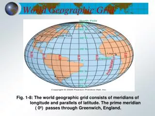
World Geographic Grid. Fig. 1-8: The world geographic grid consists of meridians of longitude and parallels of latitude. The prime meridian ( 0º) passes through Greenwich, England. Typical Graph. This is an example of a typical graph we are all familiar with.

World Geographic Grid
E N D
Presentation Transcript
World Geographic Grid Fig. 1-8: The world geographic grid consists of meridians of longitude and parallels of latitude. The prime meridian ( 0º) passes through Greenwich, England.
Typical Graph • This is an example of a typical graph we are all familiar with. • The graph is made up of different “points” with lines that connect the points.
Typical Graph Y axis • Each point has two values: • The “X” value that runs along the horizontal “X” axis • The “Y” value that runs along the vertical “Y” axis X axis
Typical Graph • X value is always stated first • Followed by the Y value • The “origin” is the point where the 2 axes intersect with a value of (0,0) Y (3,8) (9,5) X (0,0)
Typical Graph • A point can also have negative (-) values • Negative X values are to the left of the origin (0,0) • Negative Y values are below the origin Y (-X,+Y) (+X,+Y) (0,0) X (-X,-Y) (+X,-Y)
East West, North South on the Earth • Let the X axis be the Equator. • Let the Y axis be the Prime Meridian that runs through Greenwich outside of London. • Lat/Long are the 2 grid points by which you can locate any point on earth. Y X
East West, North South on the Earth N • Let each of the four quarters then be designated by North or South and East or West. W E S
East West, North South on the Earth • The N tells us we’re north of the Equator. The S tells us we’re south of the Equator. • The E tells us that we’re east of the Prime Meridian. The W tells us that we’re west of the Prime Meridian. (N, W) (N, E) (S, W) (S, E)
East West, North South on the Earth • That means all points in North America will have a North latitude and a West longitude because it is North of the Equator and West of the Prime Meridian. (N, W) Prime Meridian
East West, North South on the Earth • What would be the latitude and longitude directions in Australia? ? Prime Meridian If you said South and East , you’re right!
What is Latitude? • Latitude is the distance from the equator along the Y axis. • All points along the equator have a value of 0 degrees latitude. • North pole = 90°N • South pole = 90°S • Values are expressed in terms of degrees. 90°N Y X 90°S
What is Latitude? • Each degree of latitude is divided into 60 minutes. • Each minute is divided into 60 seconds. 90°N Y X 90°S This is also true of longitude.
What is Latitude? • For Example: • Latitude: 39° 4126' North. Longitude: 76° 4636' West... • This is close to where you live. 90°N Y X 90°S
What is Longitude? • Longitude is the distance from the prime meridian along the X axis. • All points along the prime meridian have avalue of 0 degrees longitude. • The earth is divided into two parts, orhemispheres, of east and west longitude. Y X 180°W 180°E
What is Longitude? • The earth is divided into 360 equal slices(meridians) • 180 west and 180 east of the prime meridian Y X 180°W 180°E
What is Latitude? • Our latitude and longitude might be: • 37°, 03’,13’’N • 76°, 29’, 45’’W 90°N Y X 90°S
So Where is (0,0)? • The origin point (0,0) is where the equator intersects the prime meridian. • (0,0) is off the western coast of Africa in the Atlantic Ocean.
See If You Can Tell In Which Quarter These Lon/Lats Are Located • 1. 41°N, 21°E • 2. 37°N, 76°W • 3. 72°S, 141°W • 4. 7°S, 23°W • 5. 15°N, 29°E • 6. 34°S, 151°E A B D C
1. B • 2. A • 3. C • 4. C • 5. B • 6. D
World Time Zones Fig. 1-9: The world’s 24 standard time zones each represent about 15° of longitude. They are often depicted using the Mercator projection.
East is the direction of rotation of the Earth Latitude: (90oN to 90oS) Longitude: (180oE to 180oW) Prime Meridian 0o Longitude Tropic of Cancer Latitude 23½o North 21st June 66½o 90oE 60oE 30oW 30oE 60oW 90oW 23½o 90o 22nd Sept 20th March North Pole Equator Latitude 0o 23½o 900 22nd December Tropic of Capricorn Latitude 23½o South Longitude 90o West Longitude 90oEast Longitude 60o West Longitude 60o East Longitude 30o West Longitude 30o East South Pole Positioning on the Earth’s Surface Latitude and Longitude together enable the fixing of position on the Earth’s surface.
Map Scale: • The ratio of map distance to ground distance indicated on a map as a bar graph, representative fraction, and/or verbal statement • Representation of a real-world phenomenon at a certain level of reduction or generalization
Expressions of Map Scale Fig. A-1: Common expressions of map scale
Gradient of Map Scale Fig. A-2: The scale gradient is frequently divided into three categories.
Large vs. Small Scale • Large Scale maps depict a small area with great detail • A large fraction (1:10,000) means a large scale, or smaller area • A small scale map depicts a large area with less detail • A small fraction (1:1,000,000) means a small scale map showing a larger area
Scale DifferencesMaps of Washington State Fig. 1-3: The effects of scale in maps of Washington State. (Scales from 1:10 million to 1:10,000)
World Geographic Grid Fig. 1-8: The world geographic grid consists of meridians of longitude and parallels of latitude. The prime meridian ( 0º) passes through Greenwich, England.