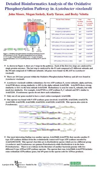
Download
1 / 16
160 likes | 308 Vues
Megan Anderton and John Cary. Tracking Strippers or. Oops… Tracking Stripers. Summary:. This activity will allow the students to evaluate the relationship of striped bass to an estuarine environment. Objectives:. In this lesson, students will be able to: Define estuarine habitat.

E N D
Oops… Tracking Stripers
Summary: This activity will allow the students to evaluate the relationship of striped bass to an estuarine environment.
Objectives: In this lesson, students will be able to: • Define estuarine habitat. • Describe striped bass. • Determine essential habitat for striped bass including physical, biological, and chemical parameters. • Graph fish movement data using an Excel Spreadsheet • Evaluate fish movement data. • Determine additional data needed to explain the movement of striped bass within the estuarine environment.
Key Concepts: Benchmarks • Science and technology in local, national, and global challenges • Humans have a major effect on other species. • Environmental quality • Many factors influence environmental quality • Natural ecosystems provide an array of basic processes that affect humans • Students should be introduced to the roles of models and simulations in these processes. • Students should present their results to students, teachers, and others in a variety of ways, such as orally, in writing, and in other forms – including models, diagrams, and demonstrations. • Solving technological problems often results in new scientific knowledge. New technologies often extend the current levels of scientific understanding and introduce new areas of research. • A variety of technologies, such as hand tools, measuring instruments, and calculators, should be an integral component of scientific investigations. • Students should be able to use scientific criteria to find the preferred explanations.
Materials: • Computer with Internet access • Microsoft Excel Time: • Estimated 3 (60 minute) class periods Procedures: • Introduction (40 minutes) • Procedures of Selecting Fish Movement Data (15 minutes) • Importing Data to Excel and Graphing (20minutes x 4 fish = 80 min) • Data Analysis and Conclusions (30 minutes)
I. Introduction: • A. Provide students with web address for Striper Tracker (www.stripertracker.org/habitat/index.html) to answer: • 1. What is a striped bass? • 2. What habitat is essential to striped bass? B. Provide students with web address (www.estuarylive.org/estuary.htm) to answer: • 1. What is an estuary? • 2. What is the importance of an estuary? C. Play the “Tag and Track Your Own Virtual Striped Bass” and answer questions in the instructions of the data collection portion of the activity (3 questions.) (use arrow keys to lower bait to capture striper)
Procedures of Selecting Fish Movement Data (www.stripertracker.org/adopt/adopt.html) • Click on “Adopt A Fish” in the left hand column • Underneath the map of the hydrophones, click to “follow an individual tagged fish” • Select 1 fish that has a minimum of 2 years (24 months) of “hits” at the hydrophone stations
III. Importing Data to Excel and Graphing • A.Highlight the data table (date, time, buoy, and hits) and copy the data • B. Open a new Excel spreadsheet and paste the data • C. Delete “time” column and “hits” column, leaving you with “date” and “buoy” columns • D. Select column A, go to the “format” tab and choose “cells”, Select the “number” tab and “Date” and click “ok” • E. Select all data and choose “chart wizard” button at the top • F. Select the XY(Scatter), select the top left chart option, click “Next”, enter a “chart title” using the name of the fish and enter the x and y axis values (dates and buoys), click “next”, click “save as new sheet” and click “finish” • G. Repeat these procedures (A-F) for 3 additional fish
IV. Using the data that you have graphed, answer the following questions: • Explain any similarities/differences between the fish selected? • Explain any seasonal patterns associated with the fish movement individually and collectively. • Test viewing the graph in a different format, i.e. “Line” graph by choosing a different selection in the Chart Wizard. Does this make your data easier to view or more difficult? Which graph type is best for your data? Explain why it is best. • Are there obvious gaps in your data points? If so, speculate about the fish movement. • Using the information gathered about the estuaries and striped bass in Section I of this activity, describe what might influence the fish movement. (hypothesis) • What additional information would you need as a scientist to explore this hypothesis? If additional information is needed, how might you obtain it? • Insert “Extension A” for NERR water quality data for advanced students/classes. • What is the significance of studying fish movement in estuaries? • Insert “Extension B” for economic activity.
Extensions: • A. To compare fish movement with relation to water quality parameters, use the National Estuarine Research Reserve System Centralized Data Management Office Information located at http://cdmo.baruch.sc.edu • 1. Click “get data” on the left hand column, select “available data” • 2. Select “Jacques Cousteau, New Jersey” from the list • 3. View the pink balloons, 1-4, which correspond to acoustic tracking buoys in the Stripertracker.org website. Determine which NERR’s station corresponds to the Stripertracker.org buoys for your fish movement data. • 4. Select a NERR’s station that corresponds to your fish data and select “water quality data”, as you scroll over the station. • 5. Queries are conducted by a single year, so you may need to pull multiple years for comparison. • 6. Click on the year drop down menu, select that year which corresponds with your data year. Click “select” • 7. After determining the water quality parameter that you wish to view, uncheck all the other selections and click “get data” (use default dates) • 8. Make a graph using one or more parameters using the “graph data” button of the headings at the top. • 9. After reviewing at least two (2) water quality parameters, look for similarities associated with the movement of your fish. Describe how the water quality parameters you selected correspond with the fish movement. Draw conclusions and explain.
B. As a scientist, you need to determine the equipment necessary for this study. You must make a list of equipment for a proposal for a million dollar research grant. Create a prioritized list of the equipment that you need and support your reasoning for your choices. Some equipment options and prices are as follows: Hydrophones and installation – $100,000 each Tagging Devices- $300 each Boat $25,000 each Water Quality Collection Devices Dissolved Oxygen $2,000 each Temperature $1,000 each Salinity $3,000 each pH $1,000 each Depth meters $5,000 each Flow meters $4,000 each Computer with wireless connection $10,000 each Personnel Costs $50,000 annually Software $10,000 each
Notes for the teacher: • Section IV.4 – Evaluating gaps in the data of fish movement – Be aware of the fact that the hydrophone buoy locations provide a “gated” area in the bay, such that the fish cannot enter the bay and exit without detection. (Unless of course, the fish is captured by an angler or dies) • Before conducting this activity – visit the NERR site to familiarize yourself with the graphing of data and variables • Suggestion (not necessary to conduct activity) – obtain an enlarged map of the buoy locations and the NERR water quality sampling locations
This is the HOOK for students to earn about real-time data