Download
1 / 6
70 likes | 184 Vues
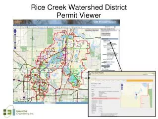
Rice Creek Watershed District Permit Viewer. Rice Creek Watershed District Permit Viewer. Description: The Rice Creek Watershed District Permit Viewer was developed to more efficiently manage their permit program in a distributed environment. Features: Web-based permit management system

E N D
Rice Creek Watershed DistrictPermit Viewer Description: The Rice Creek Watershed District Permit Viewer was developed to more efficiently manage their permit program in a distributed environment. Features: • Web-based permit management system • Manages workflow from creation to review to inspection to closeout • Conduct inspections from mobile app • Spatial Editing of permits • Custom map making Technology Stack: Developed by: Houston Engineering Contact: bfischer@houstoneng.com
MN Dept. of Agriculture Research Project Agriculture BMP Tracker http://agbmp.houstoneng.net/
MN Dept. of Agriculture Research Project Agriculture BMP Tracker http://agbmp.houstoneng.net/ Description: The MN Ag BMP Map Viewer is one component of the Minnesota Ag BMP Assessment and Tracking Tool, which was funded by a 2011 Clean Water Research Program grant from the Minnesota Department of Agriculture (MDA). Features: The Ag BMP Map Viewer is an online, interactive map interface developed within the Open Source. This Map Viewer serves two main purposes in the Ag BMP Tracking & Assessment Tool: 1) it provides a map for viewing BMP tracking data once that data is entered into the Online Ag BMP Database; 2) it provides a portal for viewing those BMPs in the context of other data that may be useful for siting future agricultural BMPs. Technology Stack: Developed by: Houston Engineering Contact: bfischer@houstoneng.com
McLeod County, MN- GIS Viewerhttp://www.co.mcleod.mn.us/mcleodco.cfm?pageID=591&sub=yes2
McLeod County, MN- GIS Viewerhttp://www.co.mcleod.mn.us/mcleodco.cfm?pageID=591&sub=yes2 Description: McLeod County, MN GIS Viewers were developed to disseminate GIS to both internal department staff and the public. McLeod County currently manages separate viewers for different departments and for internal versus external users. The viewers are easily configured in GeoMoose. Features: • Parcel lookups • Generate notification mailing lists • Map making • Map graphic sketching tools Technology Stack: Developed by: Houston Engineering Contact: bfischer@houstoneng.com