Download

1 / 20
200 likes | 303 Vues
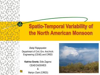
Assessment of the NCEP CFS Hindcast Runs on Predicting the North American Monsoon. Lindsey Long and Jae Schemm NOAA/NWS/NCEP/CPC Lindsey.N.Williams@noaa.gov Runs courtesy of Suranjana Saha NOAA/NWS/NCEP/EMC. Introduction. Focus on Precipitation and Atmospheric Circulation

E N D
Assessment of the NCEP CFS Hindcast Runs on Predicting the North American Monsoon Lindsey Long and Jae Schemm NOAA/NWS/NCEP/CPC Lindsey.N.Williams@noaa.gov Runs courtesy of SuranjanaSaha NOAA/NWS/NCEP/EMC
Introduction • Focus on Precipitation and Atmospheric Circulation • Look at both seasonal and interannual variability • Five varying runs allow us to look at the affect of: • Lead Time • Updates to the CFS model • Horizontal Resolution
Description of Runs • 5 different hindcast runs from 1981-2006 • Two 15-member ensemble mean hindcasts from current operational CFS • 1-month lead (May) • 3-month lead (March) • Three single runs with differing horizontal resolutions using an updated CFS • T62 • T126 • T382
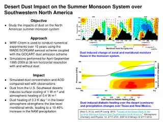
Baja California Gulf of Mexico Gulf of California Sierra Madre Occidental Complex Terrain Demonstrates the need for finer horizontal resolution
TIER 1.5 CORE AZNM NAME Sub Regions • Arizona/New Mexico Region (AZNM) ; (Higgins et al. 1998) • CORE Region (Gutzler 2004) • Tier 1.5 Region (NAMAP2)
CFS JJAS Precipitation [cm], 1981-2006 URD (1x1) T382 T126 T62 Oper T62 May Ensm Oper T62 March Ensm
CFS JJAS Precipitation Model Minus Obs [cm], 1981-2006 URD (1x1) T382 T126 T62 Oper T62 May Ensm Oper T62 March Ensm
a) AZNM Seasonal Cycle of Precipitation • CORE Region shows good example of increased accuracy with resolution and model upgrade • TIER 1.5 shows less improvement with new model runs b) CORE c) TIER 1.5 URD T382 T126 T62 T62 May T62 March
a) AZNM Seasonal Cycle of Precipitation • CORE Region shows good example of increased accuracy with resolution and model upgrade • TIER 1.5 shows less improvement with new model runs • In all regions, T382 run does well capturing monsoon onset (June-July) b) CORE c) TIER 1.5 URD T382 T126 T62 T62 May T62 March
South East Great Plains Mountain AZNM CORE CFS Diurnal Cycle of Precipitation JJAS (mm/day) l T62 T126 T382 NARR
a) AZNM Interannual Variability • Anomalous Precipitation for JJAS b) CORE c) TIER 1.5 URD T382 T126 T62 T62 May T62 March
a) AZNM Interannual Variability • Anomalous Precipitation for JJAS • Decadal Trend present in observations and CFS b) CORE c) TIER 1.5 URD T382 T126 T62 T62 May T62 March
Precipitation Correlations to URD a) AZNM Monthly d) AZNM Seasonal e) CORE Seasonal b) CORE Monthly f) TIER 1.5 Seasonal c) TIER 1.5 Monthly T62 May T62 March T382 T126 T62
Atmospheric Circulation • Prominent upper-air features in the NAME region: • Anticyclonic flow over the region • Low-level jet over the Gulf of Mexico • Low-level jet over the Gulf of California
Atmospheric Circulation (JJA) 300 mb Streamlines, 850 mb Wind Vectors NARR T382 T126 T62 Oper T62 May Ensm Oper T62 March Ensm
Atmospheric Circulation (JAS) 300 mb Streamlines, 850 mb Wind Vectors NARR T382 T126 T62 Oper T62 May Ensm Oper T62 March Ensm
Gulf of California LLJ, 850 mb Winds Strong Southerly Flow Weak Westerly Flow NARR T382
Conclusions • As expected with the complex terrain of the NAMS, increased resolution does improve the precipitation forecast. • Correlations show Interannual Variability is improving with resolution • Improvement also seen at the Seasonal and Diurnal time scales. • Comparisons of the T62 runs highlight the improvement provided by the updated atmospheric GCM model. • Change in lead time for Ensemble Mean hindcasts show only a slight improvement in May versus March • The general circulation is still a problem area. • Missing anticyclonic flow over the monsoon area • Lacking the southerly flow associated with the LLJ; therefore, the warm moisture brought into the region by this jet is missing.