Download
1 / 38
520 likes | 1.34k Vues
The Geography of Soils. Physical Geography. Key Learning Concepts:. Define soil and soil science and describe a typical soil profile. Describe soil properties of color, texture, structure, consistence, porosity, and soil moisture.

E N D
The Geography of Soils Physical Geography
Key Learning Concepts: • Definesoil and soil science and describe a typical soil profile. • Describe soil properties of color, texture, structure, consistence, porosity, and soil moisture. • Explain basic soil chemistry and relate these concepts to soil fertility. • Evaluate principal soil formation factors, including the human element. • .
1. Soils provide the foundation for animal and plant life and therefore are critical to Earth's ecosystems. • Soil is a dynamic natural body comprised of fine materials in which plants grow, and which is composed of both mineral,organicmatter (living and dead), water, and air. Specific soil conditions determine soil fertility, which is the ability of soil to support plant productivity. Plants capture sunlight and fix carbon in organic compounds that sustain the biosphere. • Soil should be seen as a living thing, not as inamimate.
2. What are the differences among soil science, pedology, and edaphology? • Soil scienceis interdisciplinary, involving physics, chemistry, biology, mineralogy, hydrology, taxonomy, climatology, and cartography. • Pedologyconcerns the origin, classification, distribution, and description of soil. Pedology is at the center of learning about soils, yet is does not dwell on its practical uses. • Edaphologyfocuses on soil as a medium for sustaining higher plants. Edaphology emphasizes plant growth, fertility, and the differences in productivity among soils. Pedology gives us a general understanding of soils and their classification, whereas edaphology reflects society's concern for food and fiber production and the management of soils to increase fertility and reduce soil losses.
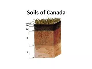
Polypedon and pedon, the basic units of soil. • A soil profile selected for study should extend from the surface to the lowest extent of plant roots, or to the point where regolith or bedrock is encountered. Such a profile, known as a pedon, is imagined as a hexagonal column. At the sides of the pedon, the various layers of the soil profile are visible in cross section. A pedon is the basic sampling unit in soil surveys. • Many pedons together in one area comprise a polypedon, which has distinctive characteristics differentiating it from surrounding polypedons. These polypedons are the essential soil individuals, constituting an identifiable series of soils in an area. A polypedon has a minimum dimension of about 1 m2 and no specified maximum size. It is the soil unit used in preparing local soil maps.
4. Characterize the principal aspects of each soil horizon. Where does the main accumulation of organic material occur? Where does humus form? • Each layer exposed in a pedon is a soil horizon. A horizonis roughly parallel to the pedon's surface and has characteristics distinctly different from horizons directly above or below. The boundary between horizons usually is visible in the field, using the properties of color, texture, structure, consistence, porosity, the presence or absence of certain minerals, moisture, and chemical processes. • At the top of the soil profile is the O horizon, composed of organic material derived from plant and animal litter that was deposited on the surface and transformed into humus. Humus is a mixture of decomposed organic materials in the soil and is usually dark in color. • At the bottom of the soil profile is the R horizon, representing either unconsolidated material or consolidated bedrock of granite, sandstone, limestone, or other rock. • The A, B, and C horizons mark differing mineral strata between O and R; these middle layers are composed of sand, silt, clay, and other weathered by-products. In the A horizon, the presence of humus and clay particles is particularly important, for they provide essential chemical links between soil nutrients and plants.
Explain the difference between the eluviated layer and the illuviated layer. Which horizons constitute the solum? • The lower portion of the A horizon grades into the E horizon, which is a bit more pale and is made up of coarse sand, silt, and resistant minerals. Clays and oxides of aluminum and iron are leached (removed) from the E horizon and migrate to lower horizons with water as it percolates through the soil. This process of rinsing through upper horizons and removing finer particles and minerals is termed eluviation; thus the designation E for this horizon. The greater the precipitation in an area, the higher the rate of eluviation that occurs in the E horizon. • Materials are translocated to lower horizons by internal washing in the soil. In contrast to A horizons, B horizons demonstrate an accumulation of clays, aluminum, iron, and possibly humus. These horizons are dominated by illuviation— a depositional process. The C horizon is weathered bedrock or weathered parent material, excluding the bedrock itself. This zone is identified as regolith. • The combination of A horizon with its eluviation removals and the B horizon with its illuviation accumulations is designated the solum, considered the true soil of the pedon. We used to call it topsoil.
Define a soil separate. What are the various sizes of particles in soil? What is loam? Why is loam regarded so highly by agriculturalists? • Individual mineral particles are called soil separates; those smaller than 2 mm in diameter (0.08 in.), such as very coarse sand, are considered part of the soil, whereas larger particles are identified as pebbles, gravels, or cobbles. The illustration shows a diagram of soil textures with sand, silt, and clay concentrations. • For good farming, the common designation loam(mixture), which is a mix of sand, silt, and clay in almost equal shares (ideal agricultural soil). A sandy loam with clay content below 30% is also excellent for farming because of its water-holding characteristics and ease of cultivation.
Everything is Connected • Worldwide, soil types show a close correlation to climate types. The moisture, evaporation, and temperature regimes associated with varying climates determine the chemical reactions, organic activity, and eluviation rates of soils. Not only is the present climate important, but many soils also exhibit the imprint of past climates, sometimes over thousands of years. • The organic content of soil is determined in part by the vegetation growing in that soil, as well as by animal and bacterial activity. The chemical makeup of vegetation contributes to acidity or alkalinity in the soil solution. For example, broadleaf trees tend to increase alkalinity, whereas needleleaf trees tend to produce higher acidity. • Landforms also affect soil formation, mainly through slope and orientation. Slopes that are too steep do not have full soil development, but slopes that are slight may inhibit soil drainage. As for orientation, in the Northern Hemisphere, a southern slope exposure is warmest (slope faces the southern Sun), which affects water balance relationships.
What cost estimates have been placed on soil erosion? • Much effort and many dollars are expended to create fertile soil conditions, yet we live in an era when the future of Earth's most fertile soils is threatened. Soil erosion is created when soil holding vegetation is removed and the land is plowed regardless of topography (soil erodes by water). Soil erosion is increasing worldwide. Some 35% of farmland is losing soil faster than it can form–a loss exceeding 22.75 billion metric tons per year. Increases in production resulting from artificial fertilizers and new crop designs partially mask this effect, but such compensations for soil loss are nearing an end. Soil depletion and loss are at record levels from Iowa to China, Peru to Ethiopia, and the Middle East to the Americas. The impact on society could be significant. One 1995 study tabulated the market value of lost nutrients and other variables at over $25 billion a year in the United States and hundreds of billion dollars worldwide. The cost to bring soil erosion under control in the United States is estimated at approximately $8.5 billion, or about 30 cents on every dollar of damage and loss.
Very important degraded soil produces less food for a world with a growing population. Soil Degradation
Dust Bowl • The Dust Bowl of the 1930s lasted about a decade. Its primary area of impact was on the southern Plains (the prairie states of Kansas, Texas, Oklahoma, and New Mexico). The drought, windblown dust and agricultural devastation helped to lengthen the Great Depression whose effects were felt worldwide. • Poor agricultural practices and years of sustained drought caused the Dust Bowl. Plains grasslands had been deeply plowed and planted to wheat. During the years when there was adequate rainfall, the land produced bountiful crops. But as the droughts of the early 1930s deepened, the farmers kept plowing and planting and nothing would grow. The ground cover that held the soil in place was gone.The Plains winds whipped across the fields raising billowing clouds of dust to the skys. The skys could darken for days, and even the most well sealed homes could have a thick layer of dust on furniture. In some places the dust would drift like snow, covering farmsteads. Analogy: If our skin were removed from our body, our fluids would leak out and we’d die. The grasses of the Great Plains acted like the earth’s skin there.
Dust Bowl (continued) • When the drought and dust storms showed no signs of letting up, many people abandoned their land. Others would have stayed but were forced out when they lost their land in bank foreclosures. • The Dust Bowl exodus was the largest migration in American history. In all, one-quarter of the population left. By 1940, 2.5 million people had moved out of the Plains states. • Through later governmental intervention and methods of erosion-prevention farming, the Dust Bowl phenomenon has been virtually eliminated, thus left a historic reference.
The salinization process in arid and semiarid soils. • A soil process that occurs in Aridisols and nearby soil orders is salinization. Salinization results from poor water practices in semiarid agricultural regions of the world. Salts dissolved in soil water are brought to surface horizons and deposited there as surface water evaporates and is replaced by capillary action. Salinization damages and kills plants when salt deposits occur near the root zone. Vegetation grows best where soils are better drained and have lower salt content. • Salination from irrigation water is also greatly increased by poor drainage and use of saline water for irrigating agricultural crops. • Migration of power and productivity upstream in Mesopotamia.
Soil Depletion Theory1st Kingdom – Sumer (Sumeria) Power based on production of fertile land. But, soil became depleted and power shifted upstream to fresh fertile land.2nd Kingdom Babylon (Babylonia) eventually depleted the soil (salinization) and power shifted farther upstream.3rd Kingdom – Assyria etcetera, etcetera moving further upstream each time. Sumeria
The soil orders associated with Earth's most productive agricultural areas Mollisol Pedon Profile • Mollisols (grassland soils) are some of Earth's most significant agricultural soils. There are seven recognized suborders, not all of which bear the same degree of fertility. The dominant diagnostic horizon is called the mollic epipedon, which is a dark, organic surface layer some 25 cm thick. As the Latin name implies, Mollisols are soft, even when dry, with granular or crumbly peds, loosely arranged when dry.
Worldwide map of the general distribution of Mollisol soils.
The slash-and-burn shifting cultivation, as practiced in the past, was a form of crop and soil rotation and conservation of soil properties? • Earlier slash-and-burn shifting cultivation practices were adapted to equatorial and tropical soil conditions and formed a unique style of crop rotation. The scenario went like this: people in the tropics cut down (slashed) and burned the rain forest in small tracts, cultivated the land with stick and hoe, and planted maize (corn), beans, and squash (interculture – planted together). After several years the soil lost fertility, and the people moved on to the next tract to repeat the process. After many years of movement from tract to tract, the group returned to the first patch to begin the cycle again. This practice protected the limited fertility of the soils somewhat, allowing periods of recovery to follow active production. However, the invasion of foreign plantation interests, development by local governments, vastly increased population pressures, and conversion of vast new tracts to pasturage halted this orderly native pattern of land rotation.
Milpa (slash and burn) intercultural planting They created a miniature rainforest so that no rain fell on exposed soil. Corn was the upper story plant. Beams (bush or climbing) provided the middle range cover. Finally, the squash vines provided the lower level of cover. This minimized soil erosion for the few years this plot of land was used. They had developed an ingenious system which the Europeans didn’t appreciate because where they had lived in Europe never got the quantity of precipitation that fell on Mesoamerica.
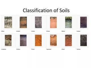
Alfisolsare a soil order in USDA soil taxonomy. Alfisols form in semiarid to humid areas, typically under a hardwood forest cover. They have a clay-enriched subsoil and relatively high native fertility. "Alf" refers to aluminium (Al) and iron (Fe). Because of their productivity and abundance, the Alfisols represent one of the more important soil orders for food and fiber production. They are widely used both in agriculture and forestry, and are generally easier to keep fertile than other humid-climate soils, though those in Australia and Africa are still very deficient in nitrogen and available phosphorus. Those in monsoonal tropical regions, however, have a tendency to acidify when heavily cultivated, especially when nitrogenous fertilizers are used. • Alfisols occupy around one-tenth of the Earth's ice-free land surface. They are dominant in many areas, such as the Ohio River basin in the United States, southern and unglaciated Western Europe, the Baltic region and central European Russia, the drier parts of Peninsular India, Sudan in Africa, and many parts of South America. • Alfisols have undergone only moderate leaching. By definition, they have at least 35% base saturation, meaning calcium, magnesium, and potassium are relatively abundant. Alfisols are commonly found in glaciated areas. Alfisols
Aridisols(or desert soils) are a soil order in USA soil taxonomy.[1] Aridisols (from the Latin aridus, for “dry”, and solum) form in an arid or semi-arid climate. Aridisols dominate the deserts and xeric shrublands, which occupy about one third of the Earth's land surface. Aridisols have a very low concentration of organic matter, reflecting the paucity of vegetative production on these dry soils. Water deficiency is the major defining characteristic of aridisols. Also required is sufficient age to exhibit subsoil weathering and development. Limited leaching in aridisols often results in one or more subsurface soil horizons in which suspended or dissolved minerals have been deposited: silicate clays, sodium, calcium carbonate, gypsum or soluble salts. These subsoil horizons can also be cemented by carbonates, gypsum or silica. Accumulation of salts on the surface can result in salinization. Aridisols
Gelisols are an order in USDA soil taxonomy. They are soils of very cold climates which are defined as containing permafrost within two meters of the soil surface. The word "gelisol" comes from the Latin gelare meaning "to freeze", a reference to the process of cryoturbation that occurs from the alternating thawing and freezing characteristic of gelisols. • Structurally, gelisols may have a B horizon and more commonly have an A horizon and/or O horizon resting on the permafrost. Because soil organic matter accumulates in the upper layer, most gelisols are black or dark brown in soil color, followed by a shallow mineral layer. Despite the influence of glaciation in most areas where gelisols occur, chemically they are not highly fertile because nutrients, especially calcium and potassium, are very easily leached above the permafrost. The permafrost greatly restricts the engineering use of gelisols, as large structures (e.g. buildings) subside as the frozen earth thaws when they are put in place. Gelisols
Ultisols, commonly known as red clay soils, are one of twelve soil orders in the United States Department of Agriculture soil taxonomy. The word "ultisol" is derived from "ultimate", because ultisols were seen as the ultimate product of continuous weathering of minerals in a humid, temperate climate without new soil formation via glaciation. They are defined as mineral soils which contain no calcareous (calcium carbonate containing) material anywhere within the soil, have less than 10% weatherable minerals in the extreme top layer of soil, and have less than 35% base saturation throughout the soil. Ultisols occur in humid temperate or tropical regions. While the term is usually applied to the red clay soils of the Southern United States, ultisols are also found in regions of Africa, Asia, and South America. Ultisols vary in color from purplish-red, to a bright reddish-orange, to pale yellowish-orange and even some subdued yellowish-brown tones. They are typically quite acidic, often having a pH of less than 5. The red and yellow colors result from the accumulation of iron oxide (rust), which is highly insoluble in water. Ultisols
In soil science, Podzols (known as Spodosolsin China and the United States of America and Podosols in Australia)[citation needed] are the typical soils of coniferous, or boreal forests. They are also the typical soils of eucalypt forests and heathlands in southern Australia. In Western Europe Podzols develop on heathland, which is often a construct of human interference through grazing and burning. Many podzols in this region may have developed over the past 3000 years in response to vegetation and climatic changes • Podzols are able to occur on almost any parent material but generally derive from either quartz-rich sands and sandstones or sedimentary debris from magmatic rocks, provided there is high precipitation.[5] Most Podzols are poor soils for agriculture due to the sandy portion, resulting in a low level of moisture and nutrients. Some are sandy and excessively drained. Others have shallow rooting zones and poor drainage due to subsoil cementation. A low pH further compounds issues, Ultisols
Oxisolsare an order in USDA soil taxonomy, best known for their occurrence in tropical rain forest, 15–25 degrees north and south of the Equator. They are classified as ferralsols in the World Reference Base for Soil Resources; some oxisols have been previously classified as laterite soils. • The main processes of soil formation of oxisols are weathering, humification and pedoturbation due to animals. These processes produce the characteristic soil profile. They are defined as soils containing at all depths no more than 10 percent weatherable minerals, and low cation exchange capacity. Oxisols are always a red or yellowish color, due to the high concentration of iron(III) and aluminium oxides and hydroxides. They also contain quartz and kaolin, plus small amounts of other clay minerals and organic matter (organic matter decomposes very quickly under the hot, moist conditions). Oxisols
Inceptisolsare a soil order in USDA soil taxonomy. They form quickly through alteration of parent material. They are more developed than entisols. They have no accumulation of clays, iron oxide, aluminium oxide or organic matter. They have an ochric or umbric horizon and a cambic subsurface horizon. Inceptisols
Mollisolshave deep, high organic matter, nutrient-enriched surface soil (A horizon), typically between 60–80 cm in depth. This fertile surface horizon, known as a mollic epipedon, is the defining diagnostic feature of Mollisols. Mollic epipedons result from the long-term addition of organic materials derived from plant roots, and typically have soft, granular, soil structure. • Mollisols occur in savannahs and mountain valleys (such as Central Asia, or the North American Great Plains). These environments have historically been strongly influenced by fire and abundant pedoturbation from organisms such as ants and earthworms. Mollisols
in both the FAO and USDA soil taxonomy, avertisolis a soil in which there is a high content of expansive clay known as montmorillonite that forms deep cracks in drier seasons or years. Alternate shrinking and swelling causes self-mulching, where the soil material consistently mixes itself, causing vertisols to have an extremely deep A horizon and no B horizon. (A soil with no B horizon is called an A/C soil). This heaving of the underlying material to the surface often creates a microrelief known as gilgai. • Vertisols typically form from highly basic rocks, such as basalt, in climates that are seasonally humid or subject to erratic droughts and floods, or that impeded drainage. Depending on the parent material and the climate, they can range from grey or red to the more familiar deep black (known as "black earths" in Australia, "black gumbo" in East Texas, and "black cotton" soils in East Africa). vertisol
Ahistosolis a soil consisting primarily of organic materials. They are defined as having 40 centimetres (16 in) or more of organic soil material in the upper 80 centimetres (31 in). Organic soil material has an organic carbon content (by weight) of 12 to 18 percent, or more, depending on the clay content of the soil. These materials include muck, mucky peat, or peat Aquic conditions or artificial drainage are required. Typically, histosols have very low bulk density and are poorly drained because the organic matter holds water very well. Most are acidic and many are very deficient in major plant nutrients which are washed away in the consistently moist soil. • Histosolsform whenever organic matter forms at a more rapid rate than it is destroyed. This occurs because of restricted drainage precluding aerobic decomposition, and the remains of plants and animals remain within the soil. Thus, histosols are very important ecologically because they, and gelisols, store large quantities of organic carbon. If accumulation continues for a long enough period, coal forms. histosol
In USDA soil taxonomy, entisolsare defined as soils that do not show any profile development other than an A horizon. An entisol has no diagnostic horizons, and most are basically unaltered from their parent material, which can be unconsolidated sediment or rock. Entisols are the second most abundant soil order (after inceptisols), occupying about 16% of the global ice-free land area. entisols