Download
1 / 26
270 likes | 454 Vues
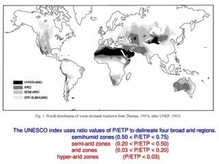
The UNESCO index uses ratio values of P/ETP to delineate four broad arid regions. semihumid zones (0.50 < P/ETP < 0.75) semi-arid zones (0.20 < P/ETP < 0.50) arid zones (0.03 < P/ETP < 0.20) hyper-arid zones (P/ETP < 0.03). 5 major regions of aridity. Desert Climate.

E N D
The UNESCO index uses ratio values of P/ETP to delineate four broad arid regions. • semihumid zones (0.50 < P/ETP < 0.75) • semi-arid zones (0.20 < P/ETP < 0.50) • arid zones (0.03 < P/ETP < 0.20) • hyper-arid zones (P/ETP < 0.03)
Have Arid Conditions Been Continuous? SAHARA DESERT EXAMPLE During the Ordovician time period (505 to 438 mya) the Sahara was actually located at the South Pole (indicated by paleomag evidence). Well preserved striations, crescentic gouges, and boulder erractics. In the early Tertiary Period (66 to 50 mya) there was a long interval of intense weathering which probably marked a period of much more humid conditions. In the Late Cenozoic Era (40 mya) is when we begin to see the onset of aridity in the Sahara. STS036-152-252 Tassili-N’-Ajjer (Plateau), Algeria March 1990The Tassili-N’-Ajjer, located in southeastern Algeria and considered part of the northern Sahara Desert, is a series of eroded sandstone plateaus (darker gray areas). Both the Tifernine Dune field and the larger area of dunes to the east result from complex wind regimes that prevail throughout this arid region that receives less than 4 inches (10 cm) of precipitation per year.
Have Arid Conditions Been Continuous?Sahara Desert Example During the Pleistocene (last 1.8 millions years) we have seen patterns of climatic oscillation. 90,000 years of aridity Dust Senegal River Deposits The last 10,000 years experience: 1. moister conditions (glaciers recede) 2. Around 4 to 5 kya there are drastic change back to more arid and semi-arid plant species in the fossil records.
Have Arid Conditions Been Continuous?Sahara Desert Example • Take home message: • Present day arid landforms and landforms of the inheritance (relict); • Temporal scales of temperature fluctuations long and short have impacts on aridity; • Multiple environmental components leading to the present day formation of arid conditions; and • Regardless of the desert environment, there have been similar environmental change, but not exactly like the Sahara Desert.
Causes of Present Day Aridity • Trade Winds • The major low latitude deserts consist of parts of the Sahara, Kalahari and Arabian Deserts and all of the Great Sandy Desert of Australia.
Causes of Present Day Aridity 2. Semi-permanent High Pressure Zones Deserts commonly associated with the subtropical highs are major portions of the Sahara, Kalahari and Arabian Deserts, Thar (Pakistan), Syrian, Lut (Iran), Gibson, Great Victoria and Simpson Deserts of Australia.
Causes of Present Day Aridity 3. Rainshadow--Examples of deserts created by rainshadows are the Great Basin (Southwestern U.S.), Takla Makan (Xinjiang Uygur, China) and the Gobi Desert.
Tarim Basin Kunlun Mtns
4. Distance from a moisture source the Kara Kum (Turkmen), Kyzyl Kum (Uzbek) and Sary Ishikotrau (Kazakh) deserts of central Asia.
Causes of Present Day Aridity 5. Proximity to Cold Ocean Currents--The currents that create some of these deserts are the Humboldt Current, which has its origins in the Antarctic region, helps to form the Atacama Desert (the driest desert in the world) the California Current, which has its origins near the Aluetian Islands, helps propagate the fog deserts of Baja California and finally the Benguela Current originating in the Antarctic, it flows along southwestern Africa where the Namib Desert is located.
Reg Reg from Libya • Why should we care? • Important from an archeological perspective (pictograms and tools) • micro-laminations in rock varnish indicator of paleo-climate, and • soil protection in arid environments. Gibber from Australia
Cuesta-Form Landscapes Hoodoos
Cuesta-Form Landscapes Arches
HORST ALLUVIAL FANS GRABEN PLAYA HORST SPACE SHUTTLE RADAR IMAGE OF DEATH VALLEY