Download
1 / 22
230 likes | 486 Vues
Hurricane Gustav (2008) Simulation by CCHE-Coast. Dr. Soumendra Nath Kuiry Assistant Professor. Environmental and Water Resources Engineering Division Civil Engineering. Model Description: CCHE-Coast. CCHE-Coast. 1. Hydrodynamic Model. 2. Hurricane Track Model. 3. Spectral-wave Model.

E N D
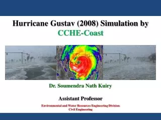
Hurricane Gustav (2008) Simulation by CCHE-Coast Dr. Soumendra Nath Kuiry Assistant Professor Environmental and Water Resources Engineering Division Civil Engineering
Model Description: CCHE-Coast CCHE-Coast 1. Hydrodynamic Model 2. Hurricane Track Model 3. Spectral-wave Model (YafeiJia) (S. N. Kuiry) (Yan Ding) HPC Lecture Civil Engineering 2/24
Hurricane Gustav (2008) Track Fig. 1: The track of hurricane Gustav (2008) by Weather Bug HPC Lecture Civil Engineering 5/24
Computational Domain Longitudinal:9137'27" W - 8740'18"W Transverse: 2834'35" N - 3046'27" N Area:440km 320km Cocodrie, LA Landfall Point Fig. 2: Computational area selected for the present study is delimited by the red line HPC Lecture Civil Engineering 6/24
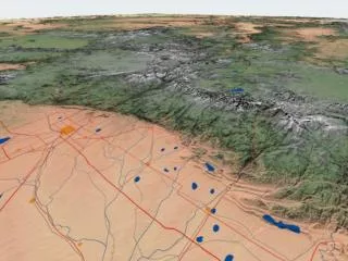
Computational Mesh (a) • The Study domain covers a large area (about 440 km 320 km). • The major features include Rivers, Lakes, Levees, Roads, Protection structures and barrier islands. • Block structured mesh were created using 17 blocks. • Each block was controlled for certain resolution. • The bathymetry was derived from SL15 mesh created by USACE. • The mesh has 2103 and 1088 grid points in the longitudinal and latitudinal directions: about 2.29 million nodes. (b) Fig. 3: (a)New Orleans storm protection System and (b) its implementation in the mesh HPC Lecture Civil Engineering 7/24
Bathymetry and Mesh Mississippi River Atchafalaya River Fig. 4: The bathymetry and the mesh consisting of 2,288,064 nodes HPC Lecture Civil Engineering 8/24
Details of New Orleans City, Structures and Rivers Fig. 5: Enlarged view showing the details of the final mesh area around Lake Pontchartrain and the Pearl River. HPC Lecture Civil Engineering 9/24
Bottom Friction Roughness coefficients are obtained from land use and land cover map of the area provided by USACE. In the extended area a constant value 0.02 is considered. Fig. 6: Manning’s roughness coefficient HPC Lecture Civil Engineering 10/24
Input Parameters • Storm Track – best track observed by NOAA • Tides - the observed tidal elevations at the Pilots Station East, SW Pass, LA is used as the tidal boundary condition at the south open sea boundary. • Waves – the observed wave data from NDBC is applied at the sea boundary. • River inflows - The stream gages USGS 07374000 on Mississippi River at Baton Rouge, LA and USGS 07381490 on Atchafalaya River at Simmesport, LA provided the inflow discharges during Hurricane Gustav (2008). • Simulation period - from 08/25/2008 0:0 hrs – 09/03/2008 0:0 hrs. HPC Lecture Civil Engineering 11/24
Boundary Conditions Mississippi River Atchafalaya River Fig. 7: The river inflows and tide at the sea boundary imposed as boundary conditions HPC Lecture Civil Engineering 12/24
Computational Challenges • Domain size • Mesh Generation • Model run • Visualization of Results HPC Lecture Civil Engineering 13/24
Results and Discussions HPC Lecture Civil Engineering 14/24
Location and Index of Stations Fig. 8: The location of observation stations for comparative study HPC Lecture Civil Engineering 15/24
Comparison of Water Surface Elevations NOAA 8741533 Pascagoula NOAA Lab, MS NOAA 8737048 Mobile State Docks, AL NOAA 8735180 Dauphin Island, AL NOAA 8762075 Port Fourchon, LA NOAA 8747437 Bay Waveland Yacht Club, MS NOAA 8760922 Pilots Station East, LA Fig. 9: Time series of computed and observed water surface elevations HPC Lecture Civil Engineering 16/24
Maximum Water Surface Elevations (b) Fig. 10: Computed maximum water surface elevation above NAVD88: (a) Forbes et al. (2010) and (b) present simulation HPC Lecture Civil Engineering 17/24
Animation: Water Surface Elevations Fig. 11: Animation of water surface elevation (01/09/08 0:0 hrs – 02/09/08 0:0 hrs) HPC Lecture Civil Engineering 18/24
Wave Parameters NDBC 42040 Luke Offshore Test Platform (a) (a) (b) (b) NDBC 42007 Biloxi station Fig. 12: Comparisons: (a) significant wave height and (b) mean wave period HPC Lecture Civil Engineering 19/24
Wind Speed Comparison Fig. 13: Time series of computed and observed wind speeds at different stations HPC Lecture Civil Engineering 20/24
Wind Direction Comparison Fig. 14: Time series of computed and observed wind directions at different stations HPC Lecture Civil Engineering 21/24
Computed Wind Field Fig. 15: Computed wind field on 1 Sep 2008 at 7:50 hrs Fig. 16: Computed wind field on 1 Sep 2008 at 16:00 hrs Fig. 17: Wind field animation (01/09/08 0:0 hrs – 02/09/08 0:0 hrs) HPC Lecture Civil Engineering 22/24
Computed Air Pressure Field Fig. 18: Computed air pressure fields on 1 Sep 2008 at 7:50 hrs Fig. 20: Air pressure field animation (01/09/08 0:0 hrs – 02/09/08 0:0 hrs) Fig. 19: Computed air pressure fields on 1 Sep 2008 at 16:16 hrs HPC Lecture Civil Engineering 23/24
Computational Resources • Multi-cores (more than 12) • NVIDIA graphic card for GPU operations • Tecplot software in the high speed computer • A Wiki of subroutines for known algorithms • Video tutorials for large scale computations HPC Lecture Civil Engineering 24/24