Download
1 / 51
910 likes | 2.2k Vues
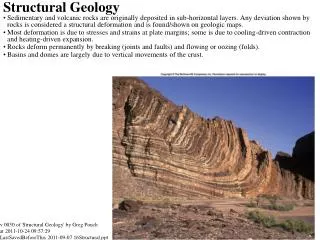
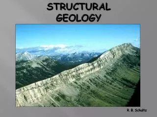
Lecture 11 Structural Geology. Rock deformation and structural geology Folds in Rock Rock fractures: Joints and Faults Geologic maps. Rock deformation and structural geology Rocks deform under stress. Deformation refers to all changes in volume and/or shape of a rock body.

E N D
Lecture 11 Structural Geology • Rock deformation and structural geology • Folds in Rock • Rock fractures: Joints and Faults • Geologic maps
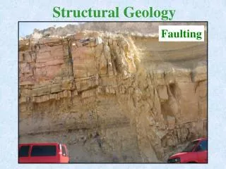
Rock deformation and structural geology • Rocks deform under stress. Deformation refers to all changes in volume and/or shape of a rock body. • Structural geology examines the present state of crustal deformation and determines the original geologic setting and the nature and direction of the earth forces (tectonic forces) that produced these rock structures. • Folding in a rock occurs in the plastic range of the rock. • Faulting occurs when the rocks break.
Laboratory experiments of deformation of marble by compressive forces under confining pressures similar to shallow crust (middle) and deeper crust (right). (M.S. Patterson).
Deformation of A) flat-lying strata. B) compressional stress tend to shorten a rock body, often by folding. C) Tensional stress acts to elongate or pull apart a rock unit. D) Shear stress acts to bend and break them. (Tarbuck and Lutgents)
Anticlines and synclines in the Calico Hills near Barstow, California. (Hamblin and Christiansen)
Descriptions of an inclined plane: strike and dip • Strike is the direction of the line produced by the intersection of the inclined plane with the horizontal plane. It is expressed as the angle of the line from the north. • Dip is the angle between the inclined plane and the horizontal plane. • Strike and dip directions are always mutually perpendicular.
Folds in Rock A fold is a bent structure that originally was planar, such as a sedimentary bed. Folds may be produced by either horizontal compression or vertical forces in the crust, just as pushing in on opposite sides of a paper or up from below.
Terms used to describe the parts of a fold: • limb: The two sides of a fold are called limbs. • axis: A line drawn along the points of maximum curvature of a layer of a fold. More strictly, it is called hinge line. • axial plane: an imaginary plane surface that divides a fold as symmetrically as possible. • plunge: If the fold axis is not horizontal, the angle of the axis with the horizontal plane is called plunge.
Types of folds • anticline: upfolds or arches of rock layers • syncline: downfolds or troughs of rock layers. • monocline: only one direction of dip prevails in a fold system. • symmetrical fold: the axial plane is vertical with the limbs dipping symmetrically from the axis • asymmetrical fold: the axial plane is tilted from the vertical with one limb dipping more steeply than the other. • overturned fold: one limb is tilted beyond the vertical • recumbent fold: this is an overturned fold "lying on its side" so that the axial plane is nearly horizontal.
Anticlines and synclines in the Calico Hills near Barstow, California. (Hamblin and Christiansen)
Folds of deformed sedimentary strata near Palmdale, California. The dashed-line indicates a fault also present. (E.J. Tarbuck)
(Top) The San Rafael monocline, Utah. (S. Trimble) (Bottom) Illustration of monocline consisting of bent sedimentary beds caused by faulting in the bedrock below.
Overturned fold. (G.S. Of Israel). One limb has been turned completely upside-down with older beds on the top.
A recumbent fold in Precambrian rocks of the Umanak area, Greenland. (T.C.R. Pulvertaft)
Outcrop (map) view of folds • Anticline: the oldest beds are in the center and the beds become progressively younger in each direction. Synclines: the youngest bed is in the center and the beds get progressively older in each direction. • Symmetrical folds have equal bed widths on opposite sides of the axial plane, but asymmetrical folds will have different bed widths on the opposite sides. • For a plunging anticline, the nose (formed by the intersection of the fold system with a horizontal plane) points in the same direction as the plunge. For a plunging syncline, the nose points in the direction opposite to that of the plunge.
The diagram shows the surface of eroded remnants of a syncline and the characteristic core of younger rocks flanked on both sides by older rocks dipping toward the core. (Press and Siever)
Anticlines and synclines. The numbers 1 through 6 indicate strata of progressively younger ages. (West, p.203)
Symmetrical and asymmetrical anticlines and synclines. Symmetrical folds have equal bed widths on opposite sides of the axial plane, but asymmetrical folds will have different bed widths on the opposite sides. (West, p.203)
Plunging folds. Note the nose of a plunging anticline in outcrop points in the direction of the plunge, while the opposite is true of plunging synclines. (Tarbuck and Lutgents)
A plunging anticline forms a a V-shape pattern pointing in the direction of plunge. This example is from near St. George, Utah. (Hamblin and Christiansen)
Domes (dome-shaped folds) and basins (bowl-shaped folds). (W.W. Norton)
Rock fractures: Joints and Faults • Joints • A joint is a crack along which no appreciable movement has occurred. • Most joints are produced when rocks are deformed by tectonic forces, with some exceptions.
Devil’s Tower, Wyoming. The columnar joints form when igneous rocks cool and develop shrinkage fractures producing elongated columns. (Thomason/Stone Images)
Joints in granitic rocks near the top of Lembert Dome, Yosemite National Park. The joints were enhanced by weathering. (E.J. Tarbuck)
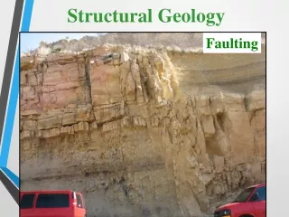
Faults • A fault is a fracture with relative movement of the rocks on both sides of it, parallel to the fracture. • Fault terminology: strike, dip of fault plane, hanging wall, footwall.
A fresh fault scarp after an earthquake in Nevada. (S. Marshak)
(a) (b) (a) Slip lineations on a fault surface. (b) Breccia, broken-up rocks along this fault. (S. Marshak)
The names of hanging wall and footwall came from miners mining along fault zones, who hung their lanterns on the hanging wall and walked on the footwall. (Tarbuck and Lutgents)
Types of faults: • dip-slip fault: normal fault, reverse fault, thrust fault • strike-slip fault: left lateral, right lateral • oblique-slip fault: has both strike-slip and dip-slip component. Note: The textbook calls it "translation fault", which is rarely used.
Types of faults. a) Normal faults, caused by tensional forces, result in extension. b) Reverse faults, caused by compressional forces, result in shortening. c) Strike-slip faults associated with shearing forces. d) Oblique slip suggests a combination of shearing and compression/tension. (Press and Siever)
A small normal fault along the road to Kolob Terraces just north of Toquerville, Utah.
Normal faulting in the Basin and Range Province. Tensional stresses elongated and fractured the crust into numerous blocks. Movement along the fractures tilted the blocks producing parallel mountain ranges. (Tarbuck and Lutgents)
The Keystone thrust fault of southern Nevada. Dark-colored limestone (Cambrian) has been thrust over light-colored Jurassic sandstone, younger by some 350 million years. (J.S. Shelton)
Diagram for a strike-slip fault (right-lateral). Note how the stream channels have been offset by fault movement. (after R.L. Wesson et al.)
Strike-slip faults are commonly expressed by a series of straight linear ridges and troughs that can be traced for long distances. Here the San Andreas fault in southern California offsets a drainage system.
The San Andreas Fault system runs from the Gulf of California and enters the Pacific from northern California. The accumulated displacement, from earthquakes and creep, exceeds 560 km over its 29-million-year history. (Tarbuck and Lutgens)