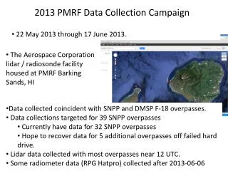
2013 PMRF Data Collection Campaign Summary and Processing Update
The 2013 PMRF Data Collection Campaign took place from May 22 to June 17, collecting lidar and radiosonde data at the Aerospace Corporation's facility in Barking Sands, HI. The campaign targeted coincident data collection for 39 SNPP overpasses, with successful data retrieval for 32. Efforts are underway to recover data from 5 additional overpasses. The lidar data mainly covers 12 UTC overpasses, with some RPG Hatpro radiometer data collected post June 6, 2013. Subsequent data processing includes calibration, bias assessment, and integrating auxiliary readings for enhanced profile analysis.

2013 PMRF Data Collection Campaign Summary and Processing Update
E N D
Presentation Transcript
2013 PMRF Data Collection Campaign • 22 May 2013 through 17 June 2013. • The Aerospace Corporation lidar / radiosonde facility housed at PMRF Barking Sands, HI • Data collected coincident with SNPP and DMSP F-18 overpasses. • Data collections targeted for 39 SNPP overpasses • Currently have data for 32 SNPP overpasses • Hope to recover data for 5 additional overpasses off failed hard drive. • Lidar data collected with most overpasses near 12 UTC. • Some radiometer data (RPG Hatpro) collected after 2013-06-06
2013 PMRF Data Processing • Decide if RS92 temperature bias warrants reprocessing. • Transfer early-release RS92 data to the STAR cal/val team. • Process lidar data and generate “best estimate” combined profiles. • Temperature: RS92 0 - 30 km, lidar 30-60 km • Humidity: RS92 0 - 3 km, lidar 3 - 20 km • Process lidar returns to add auxiliary data • Time-evolution of humidity profiles • Cloud bottom and top elevations • Add new data to 2012 comparisons with Lihue synoptic radiosonde data. • Provide access to final-release QAedRS92 and lidardata to cal/valteam.