Pearblossom Geodetic Networks
100 likes | 222 Vues
This study reviews the Pearblossom Geodetic Network from 1980 to 2001, focusing on its strain measurement results. Early 1980s data indicates frequent quarterly measurements, transitioning to annual GPS measurements by the late 1990s. Notable findings include strain rates at the San Andreas Fault: Pearblossom at 237 ± 10 ns/yr, and Landers Hector Mine at -14 ± 9 ns/yr. The research analyzes temporal changes in strain and seasonal displacements, comparing data from the SCIGN/BARGEN networks. Key references include studies by Langbein and Johnson (1997) and Langbein et al. (1982).

Pearblossom Geodetic Networks
E N D
Presentation Transcript
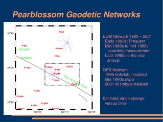
Pearblossom Geodetic Networks EDM Network 1980 – 2001 Early 1980s; Frequent Mid 1980s to mid 1990s quarterly measurement Late 1990s to the end annual GPS Network 1995 holc/tabl installed late 1990s dvpb 2001 ll01/pbpp installed Estimate strain change versus time Lancaster Palmdale San Andreas fault
Strain Changes at Pearblossom 237 ± 10 ns/yr 12 ± 10 ns/yr Landers Hector Mine -14 ± 9 ns/yr
Rate removed 237 ± 10 ns/yr 12 ± 10 ns/yr -14 ± 9 ns/yr
Temporal changes in strain??? Langbein and Johnson JGR 1997 Langbein et al. Science 1982
0.08 ± 0.08 mm/yr 0.07 ± 0.08 mm/yr
-31.05 ± 0.10 mm/yr 7.58 ± 0.03 mm/yr -204 ± 10 ns/yr
Common mode Seasonal displacements Langbein, submitted, JGR, 2007
Comparison of common mode (SCIGN/BARGEN) with translation of Pearblossom GPS network