Peace Wing
Peace Wing. An Experiment Merging Politics And Technology. A Need for Imagery. Imagery and derived products are needed to respond to and mitigate all types and phases of disasters, whether natural disasters like land slides in Turkey, fires in Indonesia or hurricanes,

Peace Wing
E N D
Presentation Transcript
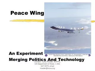
Peace Wing An Experiment Merging Politics And Technology Contact: Larry Roeder, IO/PPC, US Department of State, t: 202-647-5070, email lroeder@nova.org
A Need for Imagery Imagery and derived products are needed to respond to and mitigate all types and phases of disasters, whether • natural disasters like land slides in Turkey, fires in Indonesia or hurricanes, • or complex humanitarian emergencies like Sudan. Imagery is also useful for environmental and population studies and a myriad of other important of non-political purposes. Contact: Larry Roeder, IO/PPC, US Department of State, t: 202-647-5070, email lroeder@nova.org
Issues: • Neutrality: The government in control of a studied territory may be afraid that the imagery is being used for adverse military, intelligence or commercial. • Cost: Satellites and manned aircraft are very expensive. Satellites cost over $100 million each to build and launch. • Data Ownership: Governments and corporations often want and need a return on the cost of production. As a result, data can be expensive and distribution can also be slow. • Danger: Manned aircraft risk human lives and harm the environment. Contact: Larry Roeder, IO/PPC, US Department of State, t: 202-647-5070, email lroeder@nova.org
A Imagery Delivery System should: • Lower the cost of imagery. • Enhance data distribution. • Not risk lives or the environment. • Be trusted as politically neutral and transparent. • Operate at various altitudes and long periods of time. Contact: Larry Roeder, IO/PPC, US Department of State, t: 202-647-5070, email lroeder@nova.org
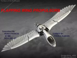
Peace Wing: An Experiment • An experiment using the Pathfinder unmanned solar powered aircraft or its next generation , a prototype series under study by. See http://www,dfrc.nasa.gov/gallery/photo/Pathfinder/index.html • Pathfinder will fly over a natural disaster in Asia, Latin America or the Caribbean. • On board sensors and cameras will produce less expensive imagery than satellites or manned aircraft. • The experiment will test political confidence building measures to reduce a reluctance by some governments to allow over flights. Contact: Larry Roeder, IO/PPC, US Department of State, t: 202-647-5070, email lroeder@nova.org
Confidence Building • The host government must see the plane before it takes off, be allowed to examine the instruments and sit in the control room so that it knows that the instruments only do specific “non-political” tasks. • All project information will be posted on ReliefWeb -- supports transparency and enhances OCHA’s role as an Emergency Coordinating body. Contact: Larry Roeder, IO/PPC, US Department of State, t: 202-647-5070, email lroeder@nova.org
Information Distribution • ReliefWeb will get a live feed of images as they occur and also act as a repository for all other project images. • Cost is decreased and effectiveness is increased because all actors in a disaster will have a common source of reliable information -- the need for alternative routes is reduced. Contact: Larry Roeder, IO/PPC, US Department of State, t: 202-647-5070, email lroeder@nova.org
Analysis • Sensor data will go to an analytical center which will transform the data into useful derived products. • All derived products are posted on ReliefWeb. • All analysis is given for free in fast moving disasters or at the lowest practical cost. Contact: Larry Roeder, IO/PPC, US Department of State, t: 202-647-5070, email lroeder@nova.org
Results The use and distribution of imagery and derived products can be increased and the cost decreased by deploying a small fleet of unmanned solar aircraft under special political constrictions to disaster prone regions. Contact: Larry Roeder, IO/PPC, US Department of State, t: 202-647-5070, email lroeder@nova.org
Partners • Department of State, IO and OES • World Bank • NASA • The Nansen Institute • USAID/OFDA • USIP Possible Partners • UN Office for the Coordination of Humanitarian Affairs • Center of Excellence in Disaster Management, Honolulu • USG GDIN Transition Team and member agencies. Contact: Larry Roeder, IO/PPC, US Department of State, t: 202-647-5070, email lroeder@nova.org
Costs, Time and USG Coordination • Costs: $1.5 million. Largely born by State/ IO out of its FY 2000 special fund, but with in-kind and financial support by the partners. • Time: The experiment will take six weeks, but will need about a year to prepare. • USG Coordination: With members of the USG International Informatics Committee -- but in consultation with international partners. Contact: Larry Roeder, IO/PPC, US Department of State, t: 202-647-5070, email lroeder@nova.org