Presentation Contents
Presentation Contents. Assessment Approach Description of Watershed and Subbasins Areas surveyed General Findings and Discussion Recommendations Upcoming Dates. Assessment Questions. The assessment used six guiding assessment questions about: History / status of salmonid populations

Presentation Contents
E N D
Presentation Transcript
Presentation Contents • Assessment Approach • Description of Watershed and Subbasins • Areas surveyed • General Findings and Discussion • Recommendations • Upcoming Dates
Assessment Questions • The assessment used six guiding assessment questions about: • History / status of salmonid populations • Salmonid habitat conditions • The condition of natural watershed and stream processes • Land use impacts on these processes • Conditions limiting salmonids (LFA) • Recommendations for improvement activities
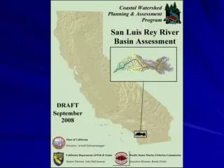
San Luis Rey Profile • 560 Square miles; 342 below Henshaw Dam • Third largest watershed in San Diego County • 242 tributaries adding up to 759 miles of perennial and intermittent stream
San Luis Rey Subbasins In order to be more specific and of value to planners, managers, and landowners, it is useful to subdivide the larger basin into smaller subbasin units whose size is determined by the commonality of many attributes including: dam and water diversions, perennial stream flow, geography, geology, land use and CalWater 2.2.1 Planning Watersheds.
Native Species Southern Steelhead Trout
Areas Surveyed • San Luis Rey River • 31 miles (19 miles in Coastal Subbasin; 7 miles in Southern Subbasin; and 5 miles in Middle Subbasin) • Tributaries surveyed • Pauma Creek – 3 reaches covering approximately 1 mile, located in the upper, middle and lower middle sections of the creek • Keys Creek – approximately 2 ½ miles in the lower reach of the creek • Small reaches (less than 1000 feet) of Ostrich Creek, Horse Creek, and Gomez Creek.
Fish History and Status • Documented and anecdotal accounts report of steelhead runs in the SLR River and some of its tributaries. • During the Department’s 2007 surveys, one adult steelhead was observed in the Coastal Subbasin; a second adult was reported by a USGS field technician in the same vicinity but not be confirmed; • A healthy population of native rainbow trout persists in the Pauma Creek watershed in the Northern Subbasin. Genetic sampling performed on these fish (1999) concluded that “it seems more than likely that these fish are part of a native coastal O. mykiss lineage.” • The Upper Subbasin also holds populations or resident native trout.
Current Habitat Conditions • Stream Flow • The Basin is not hydrologically connected. Flows have been altered throughout the Basin as Henshaw Dam impedes flows in the Upper Subbasin and the Escondido Canal diverts virtually all flows of the mainstem at the lower end of the Middle Subbasin; • Stream flows in tributaries have been reduced through extraction for anthropogenic use; • Dry or intermittent reaches in the mainstem prevent hydrologic connectivity with the estuary and thus the ocean, hindering the potential recovery of steelhead in the Basin;
Current Habitat Conditions cont. • Water Quality • Total Dissolve Solids and fecal coliform are constituents of concern, particularly in the Coastal Subbasin (Weston Solution 2007); • Stream bioassessments performed in the lower mainstem SLR River and a reference site on a tributary of Pauma Creek yielded significantly different results. The SLR River urban sites had Index of Biotic Ratings of Very Poor during both surveys, while the Doane Creek reference site was the highest rated site in the county program(Weston Solutions 2007). • The SLR estuary’s health was assessed at poor to fair based on analysis of Benthic Response Index (BRI) and Relative Benthic Index (RBI) scores. • According to the 2005 Ambient Bay and Lagoon Monitoring Program (Weston Solutions 2007), the SLR River estuary scored good for toxicology, fair for biology and good for chemistry.
Current Habitat Conditions cont. • Instream Habitat cont. • Areas of suitable spawning gravel are very limited in portions of the mainstem that are currently accessible to steelhead. • Areas containing suitable spawning gravels exist in Pauma Creek and most likely in other tributaries in the Northern Subbasin including: Gomez Creek, Agua Tibia Creek, Frey Creek and Pala Creek. • The majority of the mainstem reaches surveyed and tributary reaches in the SLR River Basin (70%) met or nearly met the target value of 80% canopy coverage • Quality pool structure is generally lacking in the mainstem throughout the basin; while a few of the reaches contained adequate shelter, only one reach surveyed met standards for pool depth;
Current Habitat Conditions cont. • The Middle and Northern Subbasins provide medium potential refugia with the Middle Subbasin containing refugia in the mainstem and within several tributaries of the Northern. However, a majority of the refugia in these subbasins is inaccessible to steelhead due to road crossings and the Escondido Canal diversion. • The Southern and Coastal Subbasin provides lower quality refugia. The Coastal Subbasin with habitat restoration could provide critical instream and estuarine rearing habitat. • While some suitable trout habitat exists in the Upper Subbasin, these areas are inaccessible due to Henshaw Dam.
Factors Limiting Steelhead Recovery • Lack of hydrologic connectivity and adequate stream flows in the mainstem and tributaries; • Presence of temporal and/or complete barriers on the mainstem and important tributaries; • Loss of estuarine habitat; • High levels of fine sediments in streams; • Competition with warm water gamefish, crayfish, and bullfrogs; • Displacement of native riparian vegetation with exotic vegetation; • Limited areas with suitable spawning gravels in mainstem and tributaries.
Barriers to Fish Passage Douglas Ave Pauma Creek SLR River Escondido Diversion Dam
SLR Estuary Past and Present 2008 1932
Non-Native Species Mosquito fish Bluegill Largemouth bass Crayfish Green sunfish Black bullhead Bullfrog
CWPAP San Luis Rey River Assessment Basin Scale Key Recommendations
Flow and Water Quality Improvement Activities • Determine proper seasonal flow releases through Henshaw Dam and Escondido Canal Diversion; • Flushing flows would also allow natural hydrologic processes occur creating and improving instream and riverine habitat; • Identify potential pollution sources and address problematic areas
Fish Passage • Work with public agencies to modify existing fish passage barriers on the SLR River and key tributaries • Meet with private landowners to discuss modifying/removing barriers located on their property
Riparian and Instream Habitat Improvement Activities • Best way to address habitat loss in southern California riparian systems is through a comprehensive program of eradication of Arrundo, Tamarisk, and other invasive aliens; • And relying on natural physical processes, especially flood dynamics, for the recovery of native natural communities and species; • Prioritize locations within the estuary where vegetation can be returned to salt tolerant species.
Erosion and Sediment Delivery Reduction Activities • Continue to encourage the use of Best Management Proctices for nutrient runoff, pesticide management, and erosion control for homeowners and agricultural and industrial uses; • Existing sediment production problem sites that have potential to deliver sediments to streams should be evaluated and mitigated.
Education, Research, and Monitoring Activities • Continue to build upon current educational outreach to the community concerning the elimination of exotic flora and fauna; • Efforts to examine water quality have been ongoing and should continue throughout the watershed; • Upon completion of 4th Street Bridge, monitor water quality and estuary conditions; • Conduct instream and fish inventories on streams of the Northern Subbasin – Gomez, Aqua Tibia, Frey, and Pala Creek
Upcoming Assessment Project Objectives and Dates • Finish Editing Report • Public Review and Comment Period (October-November 2008) • Produce Final Draft (December 2008)