Continents and Oceans!
390 likes | 544 Vues
Continents and Oceans!. A continent is a large land mass. Continents are the largest areas of land on our planet. Geographers identify seven continents and five oceans. Kindergarten time!. https://www.youtube.com/watch?v=K6DSMZ8b3LE. Surrounding our seven continents are five oceans

Continents and Oceans!
E N D
Presentation Transcript
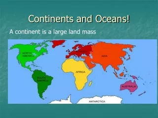
Continents and Oceans! A continent is a large land mass
Continentsare the largest areas of land on our planet. • Geographers identify seven continents and five oceans
Kindergarten time! https://www.youtube.com/watch?v=K6DSMZ8b3LE
Surrounding our seven continents are five oceans • A long, long, long time ago, there were only four oceans recognized • In recent history, around 20 years ago we started recognizing the Southern Ocean
BrainPop https://www.brainpop.com/socialstudies/geography/continentsoftheworld/ https://www.brainpop.com/socialstudies/geography/oceans/
Newest Itunes Jam https://www.youtube.com/watch?v=lQ2V-VgCJgI
Latitude and Longitude • The earth is divided into lots of lines called latitude and longitude.
Latitude • Latitude lines run east and west-horizontally. • Latitude lines come first!!! • (Side to side) • Like a ladder!!!
Longitude • Longitude lines run north and south-vertically. • Longitude lines come second! • (Top to bottom)
Lines • The lines measure distances in degrees. Longitude Latitude
Where is 0 degree? • The equator is 0 degree latitude. • It is an imaginary belt that runs halfway point between the North Pole and the South Pole. Equator
Where is 0 degree? • The prime meridian is 0 degrees longitude. This imaginary line runs through the United Kingdom, France, Spain, western Africa, and Antarctica.
It’s Tropical! • Special lines of latitude are 23.5 degrees away from the equator.
The Tropics • Tropic of Cancer is north of the equator • Tropic of Capricorn is south.
The area between these two lines is known as the “Tropics” • There are no seasons in this region because of the sun’s position in the sky
Time Zones • The Earth is divided into 24 time zones, corresponding to 24 hours in a day. • As the earth rotates, the sun shines in different areas, moving from east to west during the course of a day. • Places that have the same longitude will be in the same time zone.
Hemispheres • By using the equator and prime meridian, we can divide the world into four hemispheres, north, south, east, and west.
Compass • A compass is a tool that helps the user know what direction one is headed. • On a map, a compass or a compass rose helps the user locate these directions.
Directions • The cardinal directions are north, south, east, and west. • The intermediate directions are northeast, southeast, southwest and northwest. • They help describe the location of places in relation to other places.
Religions Legend Map Legends • The legend is the key to unlocking the secrets of a map. Objects or colors in the legend represent something on the map.
Legend Age Expectancy