Explore National Data Mapping: Aerial Photographs & Elevation
320 likes | 429 Vues
Learn to find, view, and download aerial photographs and elevation data using specialized software. Understand the difference between raster and vector data. Explore DEM, DLG, and DOQ types for mapping applications.

Explore National Data Mapping: Aerial Photographs & Elevation
E N D
Presentation Transcript
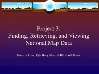
Project 3:Finding, Retrieving, and Viewing National Data Map Rick Hartlieb Ben Miller Alexis Phillips Jessica Plummer
Goal of Project • Learn about different types of aerial photographs and elevation data • Find, view, and download your own representations using specialized data viewing software • Digital Elevation Model (DEM) • Digital Line Graph (DLG) • Digital Orthophoto Quadrangles (DOQ) • Be able to comment on your experience
Difference between Raster and Vector • Vector: Defined as a point, line or polygon • Each point, line or polygon is a meaningful feature • Raster: Defined as a grid cell • Each point only has one property
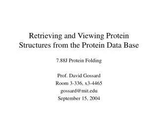
Digital Elevation Model (DEM) • General definition: raster representation of a terrain surface • Elevation data is provided at regularly spaced grid points • USGS makes DEM products for the entire country
DEM (cont) • Used to find elevation of a place • Available in several different resolutions, resolution determines use of map
DEM Example DEM (from http://seamless.usgs.gov/website/seamless/viewer.php)
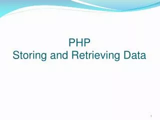
Type of Vector Elevation data display DLGs are digital vector representations of standard features on the USGS topographic map Features include Hydrography Transportation Boundaries U.S. Public Land Survey System Hypsography Man-made features Survey control and markers Non-vegetative features Vegetative surface cover Digital Line Graph (DLG)
DLG (cont) • Each category of features is digitized separately, then put together with other features in multiple layers • Useful for displaying multiple features together
DLG Example Displaying elevation, hydrographic and transportation data (from online text)
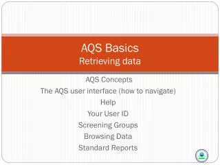
Digital Orthophoto Quadrangles (DOQ) • Raster representation of rectified air photos • Orthorectification: lining up air photos to remove relief and displacement error • Each USGS DOQ usually covers only ¼ of a standard quadrangle, so they are known as Digital Orthophoto Quarter Quadrangles (DOQQ) • DOQQ can be used to accurately measure distances
DOQ Example DOQQ of Washington, DC (from http://edc.usgs.gov/products/aerial/doq.html)
Downloading Your DEM Image • Due to the nature of these files, you may wish to create separate files in your web site folder. • Ex: Project 3, DEM, etc • Use Mozilla Firefox internet provider. (Internet explorer had issues downloading) • Go to: http://seamless.usgs.gov • Click on map of United States: (View and Download United States Data) • Using the zoom tool, outline the area of interest.
Downloading Your DEM Image (cont) • Double check the resolution of the DEM. • Go under elevation tab on right side of screen. • Scroll down until you find NED Shaded Relief (1 arc second), and select it. • Downloading • This can be found on the left side of the screen. • Select the define download area. • Using the same format as selecting your area, highlight the area that you wish to download
Downloading Your DEM Image (cont) • Once the green outline is completed, click the download button. • When opening, save to disk. • When opened, highlight all of the compressed folders and click extract all. • Make sure that where this information is saved is on your network files.
Applying Your DEM Image • Open ARC map (blank document) • Click on add data (top of screen, plus sign with yellow background) • Use the “connect to folder” button to find your files. • When located, click on the folder until it eventually opens up to the image file. This may be buried in a few folders. Your image will be listed under the metadata file. • Once imported, the DEM is finished. • Use the metadata to identify the quadrangles of the image.
Downloading Your DLG Image • Before starting, created a ‘DLG’ folder that you will be able to locate. • Using Mozilla Firefox, go to http://arcdata.esri.com/data/tiger2000/tiger_download.cfm. • Select your state from the scroll down menu. “Submit selection”. • Select your county from the scroll down menu. “Submit selection”.
Downloading Your DLG Image (cont) • Select at least 5 variables. • Example: Line Features – Roads, Water Polygons, and so forth. • Click “Proceed to Download.” • Click “Download File.” • Save the files to disk. Once downloaded click “Open”
Extracting Your DLG Files • Select all files and click “Extract all” on the left side of the screen.
Extracting Your DLG Files (cont) • Click “Next.” Browse for the DLG folder you created. Click “Next.” • Make sure “show extracted files” is checked and click “Finish.”
Extracting Your DLG Files (cont) • This will open your DLG folder. Right click on each zipped file and select “Extract All…” • Important: Make sure you browse for your DLG folder like in the previous step.
Applying Your DLG Image • Open ArcMap. Select ‘OK’ for ‘A new empty map.’ • Click File > Add Data and add your layers from your DLG folder.
Obtaining a DOQ • Using Mozilla Firefox, go to http://seamless.usgs.gov • Click on “View and Download United States Data” on the right side of the screen
Navigating the Site • Use the Zoom tool located in the top box on the left side of the screen • Zoom in to your hometown • On the right hand side, different layers can be displayed or ignored by selecting or deselecting various check boxes under the headings • Most likely, road identifications will only get in your way, deselect them if you so choose, they are under “Transportation”
Navigating the Site (cont) • Under “Orthoimagery,” select the box for “DOQQ Black and White Mosaicked Image” • Open the “Elevation” tab and deselect all options there. Typically, some options under this heading are selected by default. If they are selected, it will cause viewing problems in ArcMAP. • Please note, sometimes the viewer box is temperamental, try selecting or deselecting random boxes, such as the road labels under the “Transportation” tab
Downloading your DOQ • On the “Layers” tab, on which you have been working, there are two tabs, “Display” and “Download.” • Click on the “Download” tab just under the word “Layers.” • Deselect all options under the “Elevation” tab • Under the “Orthoimagery” tab, select the box for “1m B&W DOQQ, UTM Zone --” • On the left of the viewer box, the fourth box down is labeled “Downloads.” Select the Define Download Area tool, located in the top left box under “Downloads.”
Downloading Your DOQ (cont) • Use the selection box to select the area of your hometown, a new dialog box will appear, and within it, choose the option to download. (It should download the file to your desktop by default.) • After the zipped file appears on your desktop, right click on it and select “Extract All.”
Applying Your DOQ • The ArcGIS program is located on most ITS computers on campus. • Go to Start > All Programs > Database & Info Systems > ArcGIS > ArcMAP. • In the ArcMAP program go to File > Add Data. • In the Add Data dialog box, there will be a dropdown menu. The second box to the right of the menu is the “Connect to Folder” button.
Applying Your DOQ (cont) • Click it, and you will be able to browse your computer for the new file that you just downloaded. • Find the map file in your folder, it will have a brownish-green square icon next to it. • After the rastered DOQ is loaded, go to File > Export Map. • Save your map as a jpeg, and you are ready to go for project 3.
Today we talked about… • Different types of aerial photographs and elevation data • How to create DLGs, DEMs, and DOQs • For additional resources look at: • http://www.geog.psu.edu/courses/geog121/projects/proj3_example.html • http://www.personal.psu.edu/rjh5005/Project%203.htm
Sources • Understanding Geographic Data (the online text, Module 4) • http://www.terrafly.com/usgs.html • http://seamless.usgs.gov • http://arcdata.esri.com/data/tiger2000/tiger_download.cfm