Operations and ITS Data Tools – Turning Data into Information
Operations and ITS Data Tools – Turning Data into Information. TRANSPO. October 2012. Anita Vandervalk , P.E. Cambridge Systematics , Inc. . Agenda. Why is this important? Which data? What decisions? Challenges Solutions and tools Future outlook. Why is this Important?.

Operations and ITS Data Tools – Turning Data into Information
E N D
Presentation Transcript
Operations and ITS Data Tools – Turning Data into Information TRANSPO October 2012 Anita Vandervalk, P.E. Cambridge Systematics, Inc.
Agenda • Why is this important? • Which data? • What decisions? • Challenges • Solutions and tools • Future outlook
Why is this Important? • Performance Management in an era of declining budgets • Information industry - Rapid changes in technology and infrastructure for data sharing • Breadth of technologies for data management and dissemination continues to increase • Complexity and cost of deploying these tools continues to fall • Rapid growth in open source software solutions and low-priced, third-party hosting services • Access to data necessary • Analyzing and evaluating management and operations strategies • Making the case for greater levels of investment in operations
MAP 21 – Focus on Performance Measurement • National Goal Areas: 1.) Safety; 2.) Infrastructure condition; 3.) Congestion reductions; and 4.) System reliability • ITS is needed to measure and improve safety, congestion, system reliability, and freight movement • Contains strong language supporting Transportation Systems Management and Operations (TSM&O) • Potential for a large ITS planning effort out of RITA/JPO • Section 513 requires a comprehensive plan be developed to assess ITS deployment activities across all modes • Continues funding for the Connected Vehicle Program • Includes research statements on several Ops and ITS areas
Transportation Agency Challenges • Faced with • Big Data, lots of (new) data • Technology/Innovation advances • Aging Infrastructure • Outdated IT strategies • Evolving customer expectations • Information Management challenges • Need • INFORMATION – Organized and Fused for Decision Making • A well designed strategy for data, analytical tools and information technology to support and institutional new processes around economics, freight, project selection, PMs
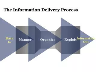
Data Management Services Framework Forecasting/ Modeling Tools Communication Decisions Operations Planning Funding Projects Policy Programming Data Information Collection Analysis Integration Visualization BUSINESS REQUIREMENTS
Which Data? • Traveler Information Systems • Current traffic conditions (e.g., travel time, speed, level of congestion) • Traffic incidents, work zone, and/or lane closures • Traffic Control Systems • Time and location of traffic control actions (e.g., ramp metering, traffic signal control, lane control signals, message board content) • Incident and Emergency Management Systems • Location, cause, extent, and time history of roadway incident/emergency detection and clearance, incident timeline. • Roadway Infrastructure Data • Roadway characteristics, intersection data, traffic control data
Which Data? • Vehicle Probe Data: Recent “real-time” speed and travel time • Historical speed and travel time; data quality measures – completeness, accuracy, latency; and validation • State/Local Generated Detector Data • Recent “real-time” volume, occupancy, speed, travel times, vehicle type; and historical volume, occupancy, speed, travel times • State/Local Work Zone • Location, agency, lanes closed, date/time, duration • Weather Data • State/local RWIS data, NWS (or equivalent) data – date/time, roadways affected, type, intensity
Which Data? • Advanced Public Transit Systems • Transit vehicle passenger boardings by time and location, vehicle trajectories, passenger origins, and destinations • Network Typology • Link capacity, free flow speed, number of lanes • Origin/Destination Data • Surveys, travel diaries, or direct monitoring • Traffic Monitoring and Detection Systems • Vehicle volume, speed, classification, weight, turning movements, and position trajectories
NEW DATA SOURCES FROM PRIVATE SECTOR • Toll tag readers • Toll tag readers deployed at various points on a roadway network • Electronic tags, antennas, readers, and a central computing and communication facility • Bluetooth device matching • Computers, car radios, navigation devices, PDAs, cell phones, headsets, and other personal devices are Bluetooth enabled • Unique Median Access Control (MAC) addresses to Bluetooth equipped devices • Travel time measurement involves identifying and matching the MAC address of Bluetooth-enabled devices carried by motorists as they pass a detector location
NEW DATA SOURCES FROM PRIVATE SECTOR • Wireless location technology • Using signaling information from cell phones (such as cell tower handoffs) to anonymously track wireless devices as they traverse a roadway network • Major vendors of the technology include Cellint (TrafficSense system), AirSage, and Delcan • Crowd-sourcing • Obtaining real-time traffic congestion information from drivers’ GPS-enabled mobile phones • Relies on a large number of users and is primarily to support personal navigation systems and mobile applications
NEW DATA SOURCES FROM PRIVATE SECTOR • Private data providers • Combine information from multiple probe technologies such as cell phones, toll tags, crowd-sourcing, and fleet-based GPS probe vehicles, as well as data from existing fixed-sensor networks such as loop- or radar-based detection • Data is then fused to provide real-time travel time estimates and incident information • Private data sources include INRIX, Navteq Traffic, TomTom, Clear Channel’s Total Traffic Network and American Transportation Research Institute (ATRI)
Which Programs? (TSM&O) • Traveler Information Systems • Active Traffic Management • Traffic Incident Management • Maintenance Activity Planning • Work Zone Management • Event Management • Traffic Control Device Synchronization • Road Weather Information Systems • Regional Traffic Management Centers
Which Programs? • Freight Management and Commercial Vehicle Operations; • Electronic Toll and Fare Collection • Congestion Management Process • Performance Measures • ITS Strategic Planning • Managed Lanes
Which Decisions? • Planning for Operations • Investment • Project priorities • Types of strategies • Real Time Management • Traveler Information • Work Zones • Weather
Challenges • Technical • Development and maintenance of hardware and software • Specifications for data collection, analysis, archiving, and reporting. • Institutional • Centralized policy-making, and decentralized execution of policies • Limited appreciation by decision-makers of the role of data systems in supporting business operations • Lack of formal policies and standards
Challenges with Data Integration • Data Integration • Data Resolution • Data Quality • Maintaining extensive electronic field equipment (sensors and communication) • Active Versus Passive Archiving • Rigid Data Format Standards versus Flexible Formats with Metadata • Data Integration (Fusion) Issues • Location Matching • Version Control
Transportation Data Formats! • TranXML, TMDD, Data.gov, geospatial reference frameworks (e.g., TMC codes), Apache Software Foundation Object-Oriented Data Technology, NTCIP, and TCIP. Others will be included such as the National Information Exchange Model (FHWA Office of Policy is currently examining this model as a possible standard), UN-recommended UN/EDIFACT (which is the only international standard and is predominant outside of North America and as well predominant in life science and pharmaceutical industry), U.S. standard ANSI ASC X12 (X12)(predominant in North America), TRADACOMS standard developed by the ANA (Article Numbering Association) (predominant in the UK retail industry), ODETTE standard used within the European automotive industry, ebXML, used by many Asian community systems, WCO standards, such as WCO data model and ASYCUDA.
Data Business Planning • What is a Data Business Plan? • A plan for efficient utilization of people, processes, and technology, to support management of data and information within an organization • The data business plan framework links business objectives, programs, and processes to data systems, services and products
Data Management and Governance • Data Management • Development, execution and oversight of architectures, policies, practices, and procedures to manage the information life-cycle needs of an enterprise in an effective manner as it pertains to data collection, storage, security, data inventory, analysis, quality control, reporting, and visualization • Data Governance • Execution and enforcement of authority over the management of data assets and the performance of data functions. The implementation of data governance includes participants from many areas of the organization
FHWA Office of Operations – Data Business Plan • GOAL 1. Improve the coordination and communication mechanism across U.S. DOT and FHWA offices involved with roadway travel mobility data to avoid investing resources in the same or similar types of data related programs. • Objective 1.1. Identify gaps and redundancies in roadway travel mobility data programs. • Objective 1.2. Devise “rules of engagement” regarding collaboration of the data functions for roadway travel mobility data.
FHWA Office of Operations – Data Business Plan • GOAL 2. Improve the coordination of the connected vehicle data capture program with other related data programs within U.S. DOT and FHWA. • Objective 2.1. Identify how current and planned data from the connected vehicle initiative can support existing data programs. • Objective 2.2. Identify how data from other mobility related programs within U.S. DOT and FHWA can support the connected vehicle initiative. • Objective 2.3. Identify existing/future data inventory and data structures/ policies/governance practices that could be applicable to the Research Data Exchange.
INRIX Analytics Tool Cloud-based service that combines Traffic Archive with real-time and historical analytics tools Real-time Dashboard highlighting bottleneck locations, 99status and history Historical analysis tools to enable configurable graphing, 99plotting, and mapping traffic performance measures Configurable Massive Data Downloader to extract 99detailed Traffic Archive data by time, road segment, etc. Options to add agency data (sensors, incidents, work 99zones, etc.) to increase utility of analysis
The Cloud • National Association of State Chief Information Officers (NASCIO) has published an exhaustive set of resources • U.S. government is • mandating agency IT resources migrate to the cloud (“cloud-first” strategy) • highly concerned with data security • larger in scale than any State or individual State agency/DOT • an information and policy resource
State DOT Cloud use Survey • All 50 states contacted • 16 states responded • Lots of variation of cloud users, agencies considering the cloud, and agencies not using or considering the cloud • Storage and availability of GIS is a very common application for the cloud • SaaS (remote access to an application) is more common than IaaS (remote storage of agency data)
What the future holds • Increasing public involvement in managing transportation • Evolving role of ITS and Operations • Increasing private sector data sources – Issues • Common definitions for performance measures (how to calculate from low-level data) • Integration with agency data: volumes, incidents, work zones, weather, highway location • Distinguish O/D travel times • Technology and Innovation • ????
FHWA/Saxton Labs Data Sharing Framework/Virtual Data Warehouse - Goals • Bring together many types of transportation data (probe data, traffic counters, incident locations, weather events) to give planners and operators a multi-faceted view of transportation performance overtime and by select location • Based on Concept of Operations, User Needs and Requirements, addressing: • Technical issues - data integration issues • Institutional issues - business rules • Partner agency involvement • Software addresses access/feed, connection to applications
Framework Strategic Outcomes • Framework is widely adopted by states and regions across the U.S. • Demonstration regarding how data sharing can support modeling, operations and planning • Planners and operations managers have complete and accurate information on the operational performance of the regional transportation system • Planning and investment decisions reflect all available and relevant data • MPOs and State DOTs are better able to meet new performance measurement requirements of MAP-21 • “Start using operations data – eliminate barriers”