Tropical Circulation and El Ni no
590 likes | 814 Vues
Tropical Circulation and El Ni no. ITCZ Intertropical Convergence Zone. Low pressure in equatorial regions due to warm air rising (air rises to tropopause). Just below tropopause : air moves poleward to subtropics, where it sinks, spreads out at surface,

Tropical Circulation and El Ni no
E N D
Presentation Transcript
ITCZ Intertropical Convergence Zone Low pressure in equatorial regions due to warm air rising (air rises to tropopause)
Just below tropopause: air moves poleward to subtropics, where it sinks, spreads out at surface, splits: poleward or equatorward: Hadley Cell tropopause 30°N equator 30°S
Trade winds at surface converge at equator • Band of clouds in satellite image represents ITCZ (middle of Hadley Cell)
Trade winds Surface arms of the Hadley Cells make up the trade winds: • Steady winds from 0 – 30° N and S • In Northern Hemisphere: NE • In Southern Hemisphere: SE
Subtropical highs • Winds aloft in Hadley cells are flowing poleward • Coriolis effect prevents them from flowing further north • Therefore air begins to pile up at 30 degrees • surface pressure rises; • air sinks and diverges; • warms as it sinks; • clear skies
Northern Hemisphere Winter: Icelandic Low Aleutian Low Canadian High Siberian High Azores Bermuda High Pacific High
Canadian High Siberian High Icelandic Low Aleutian Low Azores Bermuda High Pacific High
Northern Hemisphere Summer: • 2 continental highs (Canada and Siberian) gone • Monsoonal low over Asia • Oceanic lows weaker due to relatively cold ocean (compared to land) • Azores Bermuda High and Pacific High closer to poles and have higher central pressures
Southern Hemisphere Analogous except continental variations not as strong: no large landmasses: • Strongly developed oceanic Highs in summer
Canadian High Siberian High Icelandic Low Aleutian Low Azores Bermuda High Pacific High
Southern Hemisphere Analogous except continental variations not as strong: no large landmasses: • Strongly developed oceanic Highs in summer • Strongly developed oceanic lows in winter
Pacific High Azores Bermuda High Monsoonal Low
ITCZ migrates with seasons because zone of maximum heating migrates with subsolar point • Zone of maximum heating varies depending on surface( land or water)
monsoon • Caused by seasonal shifting of ITCZ • Most pronounced over Asia : • large Asian landmass • Himalayas enhance orographic precipitation
January: very cold air over Asia causes surface pressure to rise strong HIGH develops (Siberian High); southwest wind off continent: dry warm air Result:Winter monsoon: dry Aloft LOW land Surface HIGH ocean
Canadian High Siberian High Icelandic Low Aleutian Low Azores Bermuda High Pacific High
July: heating of continent leads to reversal of surface and upper level winds. Divergence aloft, promotes uplift; Onshore winds, bringing moist stable air from Indian Ocean to Asian continent Cloud formation enhanced as air rises over Himalayas Result: summer monsoon: very heavy rain HIGH land LOW water
Pacific High Azores Bermuda High Monsoonal Low
ENSO (El Nino / Southern Oscillation) • a Cycle with 3 phases: • El Nino • La Nina • Neutral (“normal”) • 3-7 yr intervals (average = 40 months) • Glacial cores suggest this cycle has been going on for 1500 years
Neutral (normal) 1. Easterly trade winds move warm surface water west over equatorial Pacific • Sea surface temperature 8 C higher in Indonesia than Ecuador • Sea surface is 0.5 m higher in Indonesia than Ecuador
2. Low pressure over warm western Pacific • More rainfall over western Pacific • Convective cell develops: Walker Circulation (Low in west; High in east) West Pacific East Low High
3. Along west coast of south America, upwelling of cold, nutrient-rich water replaces warm surface water, cools surface • Due to Ekman Spiral:
Ocean water moves with wind; as it moves, it is deflected by the Coriolis effect Surface water movement transfers momentum to layer of water immediately underneath, which is deflected to right of motion of layer above; etc. Creates a spiral to a depth of about 100 m (Ekman Spiral) 45° Surface current wind Net transport of water
Result of Ekman spiral: bulk of water transport is 90 degrees from wind direction (converging wind, diverging water, moving west ) As warm surface water moves west, diverging cold subsurface water upwells to replace it; (rich in nutrients, part of aquatic food chain)
NE, SE trades Ekman transport ITCZ Result of Ekman spiral: bulk of water transport is 90 degrees from wind direction (converging wind, diverging water, moving west )
As warm surface water moves west, diverging, cold subsurface water upwells to replace it; (rich in nutrients, part of aquatic food chain) Upwelling water North South equator
4. thermocline (17 degree C line) Warmer than 17 degrees Colder than 17 degrees
Summary of neutral conditions: Eastern Pacific: W coast S. America Western Pacific : Indonesia, Australia HIGH LOW Cold water
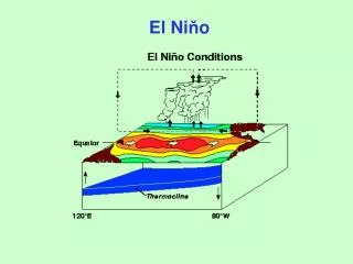
El Nino 1.relaxing of trade winds (may even flow eastward) in central and western Pacific
2.warmer water than usual in eastern Pacific warm water sloshes eastward to coast of Americas
3. no longer have strong convectional low over west Pacific • Low over east : rising air: • rain: flooding in Peru, California • High over west: sinking air: • drought in Indonesia, Australia • “Southern Oscillation”: inverted pattern of west and east Pacific pressures
4. thermocline (17 degree C line) depressed in east Pacific; elevated in west Pacific
Global effectsof El Nino: hard to predict due to other interfering factors, But, in general, places that are vulnerable to droughts and flooding are most likely to be damaged by El Nino Polar front jet shifts north of its usual place Low over Pacific draws warm air into Canada and N. US higher than normal temp in west Canada and upper plains of US; southern US: low pressure draws cold moist air in, bringing lower than usual temps and rain • US weather: SE US wet • N US and Canada: warmer
Summary of El Nino conditions: HIGH LOW Warm water moves east > 17°C < 17°C
La Nina(hyper-neutral) (Does not always follow an El Nino) 1.Cold water replaces warm pool in eastern Pacific; COLDER than normal/neutral water in east Pacific
3. thermocline (17 degree C line) Warmer than 17 degrees Colder than 17 degrees
Summary of La Nina conditions: Eastern Pacific: W coast S. America Western Pacific : Indonesia, Australia HIGH LOW Cold water
La Nina’s effects: • Very heavy rain, flooding in western Pacific • Strengthening of Atlantic hurricane season • Wetter Pacific northwest
TOPEX/Poseidon and Jason-1 satellite missions • Records sea surface height • Colors show sea level height relative to average • Higher heights correspond to warmer temps