Exploring the Future of GIS: Tools, Software, and Opportunities for Development
As GIS technology evolves, various platforms like Esri's ArcGIS, QGIS, and others shape the landscape. From powerful tools like SQL Server and Google Maps to programming languages like Python and Java, professionals face choices in software capabilities, sector support, and usability challenges. While Esri's suite remains popular within the US, alternatives like GRASS, MapInfo, and DIVA GIS cater to specific needs. The road ahead offers many opportunities for aspiring GIS experts to develop skills through classes, internships, and projects that make a difference in decision-making and data analysis.

Exploring the Future of GIS: Tools, Software, and Opportunities for Development
E N D
Presentation Transcript
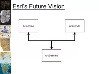
Esri’s Future Vision ArcServer ArcOnline ArcDesktop
Jim’s Future Vision ArcOnline ArcServer SQL Server GoogleMaps GeoServer PostgreSQL ERMA GBIF OpenStreetMap MapServer MySQL EarthExplorer GISIN OpenStreetMap “NoSQL” BlueSpray NationalMap BISON Python Files & Internet C/C++ Java ArcDesktop Visio R Excel 7-Zip GME Illustrator BlueSpray MS-Word DNRGPS FarSite MapInfo Photoshop PowerPoint FWTools FragStats QGIS Quark Express IDRISI HEC-RAS Maxent
ArcGIS • Largest Selling GIS Software Application • Broad support in many sectors • Expensive • Slow • Excellent Help • Many Quality Issues • Not popular outside the US
There are lots of options • GRASS: Really hard to use • Quantum GIS: Not as hard to use • DIVA GIS: Easy, not as full featured • MapInfo: Marketing & Business • Autodesk: CAD, Utilities • Intergraph: GeoMedia • IDRISI: Clark University • Smallworld: ?
Utilities • FWTools • Proj4 – Projectors (SRS conversions) • GDAL – Raster file format conversions • OGR - Vector file format conversions • EPSG • European Petroleum Standards Group • Database of SRSs • 7-zip • Decompression • DNRGPS (formerly DNRGarmin)
Modeling/Analysis Software • Geospatial Modeling Environment • Primarily Wildlife Modeling • Was Hath’s Tools • R • Free statistics package • Some spatial functions • SAGA • System for Automated Geoscientific Analysis • IDRISI • Image processing and analysis
Vertical Applications • HEC-RAS: • Hydrologic Engineering Centers River Analysis System • Army Corp of Engineers • Fire: • BehavePlus • FlamMap • FARSITE • Landscape Analysis: • Fragstats • Others…
Where to go from here • GSP 370: Intermediate GIS • GSP 118 -> 318: Spatial Programming • GSP 330: Mobile Mapping • GSP 316: Cartography • GSP 216: Remote Sensing • Esri University (some free classes) • Online classes, blogs, tutorials
What to do now? • Develop your own projects and datasets • Find your style • Find what you are interested in (and enjoy) • Help people make better decisions! • Hang in there! (it gets better) • Find internships, volunteer work, and jobs where people need GIS • Develop: • Experience • Relationships