Download
1 / 1
10 likes | 126 Vues
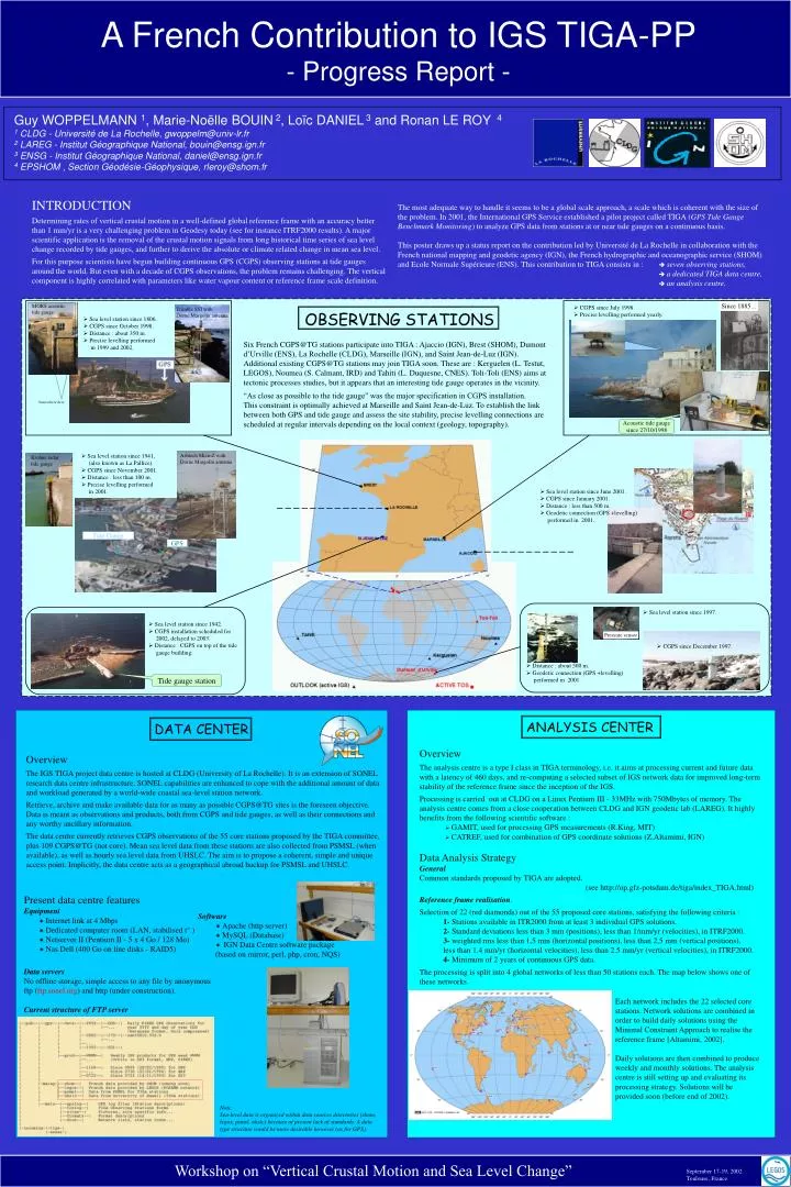
This progress report outlines the contributions made by Université de La Rochelle and French agencies to the International GPS Service's TIGA (GPS Tide Gauge Benchmark Monitoring) project. It highlights the establishment of seven continuous GPS observing stations at tide gauges throughout France, a dedicated data center, and an analysis center for processing GPS data related to sea level change. The report emphasizes the challenges of measuring vertical crustal motion and the importance of accurate long-term monitoring for climate-related sea level change.

E N D
Tide Gauge GPS Since 1885... DATA CENTER OBSERVING STATIONS ANALYSIS CENTER A French Contribution to IGS TIGA-PP- Progress Report - Guy WOPPELMANN 1, Marie-Noëlle BOUIN 2, Loïc DANIEL 3 and Ronan LE ROY 4 1 CLDG - Université de La Rochelle, gwoppelm@univ-lr.fr 2 LAREG - Institut Géographique National, bouin@ensg.ign.fr 3 ENSG - Institut Géographique National, daniel@ensg.ign.fr 4 EPSHOM , Section Géodésie-Géophysique, rleroy@shom.fr INTRODUCTION Determining rates of vertical crustal motion in a well-defined global reference frame with an accuracy better than 1 mm/yr is a very challenging problem in Geodesy today (see for instance ITRF2000 results). A major scientific application is the removal of the crustal motion signals from long historical time series of sea level change recorded by tide gauges, and further to derive the absolute or climate related change in mean sea level. For this purpose scientists have begun building continuous GPS (CGPS) observing stations at tide gauges around the world. But even with a decade of CGPS observations, the problem remains challenging. The vertical component is highly correlated with parameters like water vapour content or reference frame scale definition. The most adequate way to handle it seems to be a global scale approach, a scale which is coherent with the size of the problem. In 2001, the International GPS Service established a pilot project called TIGA (GPS Tide Gauge Benchmark Monitoring) to analyze GPS data from stations at or near tide gauges on a continuous basis. This poster draws up a status report on the contribution led by Université de La Rochelle in collaboration with the French national mapping and geodetic agency (IGN), the French hydrographic and oceanographic service (SHOM) and Ecole Normale Supérieure (ENS). This contribution to TIGA consists in : seven observing stations, a dedicated TIGA data centre, an analysis centre. MORS acoustictide gauge CGPS since July 1998. Precise levelling performed yearly. Trimble SSI with Dorne Margolin antenna Sea level station since 1806. CGPS since October 1998. Distance : about 350 m. Precise levelling performed in 1999 and 2002. Six French CGPS@TG stations participate into TIGA : Ajaccio (IGN), Brest (SHOM), Dumont d’Urville (ENS), La Rochelle (CLDG), Marseille (IGN), and Saint Jean-de-Luz (IGN). Additional existing CGPS@TG stations may join TIGA soon. These are : Kerguelen (L. Testut, LEGOS), Noumea (S. Calmant, IRD) and Tahiti (L. Duquesne, CNES). Toli-Toli (ENS) aims at tectonic processes studies, but it appears that an interesting tide gauge operates in the vicinity. “As close as possible to the tide gauge” was the major specification in CGPS installation. This constraint is optimally achieved at Marseille and Saint Jean-de-Luz. To establish the link between both GPS and tide gauge and assess the site stability, precise levelling connections are scheduled at regular intervals depending on the local context (geology, topography). Somewhere here Acoustic tide gauge since 27/10/1998 Sea level station since 1941, (also known as La Pallice). CGPS since November 2001. Distance : less than 100 m. Precise levelling performed in 2001. Ashtech MicroZ with Dorne Margolin antenna Krohne radartide gauge Sea level station since June 2001. CGPS since January 2001. Distance : less than 500 m. Geodetic connection (GPS +levelling) performed in 2001. Sea level station since 1997. Sea level station since 1942. CGPS installation scheduled for 2002, delayed to 2003. Distance : CGPS on top of the tide gauge building. Pressure sensor CGPS since December 1997. Distance : about 500 m. Geodetic connection (GPS +levelling) performed in 2001. Tide gauge station Overview The analysis centre is a type I class in TIGA terminology, i.e. it aims at processing current and future data with a latency of 460 days, and re-computing a selected subset of IGS network data for improved long-term stability of the reference frame since the inception of the IGS. Processing is carried out at CLDG on a Linux Pentium III - 33MHz with 750Mbytes of memory. The analysis centre comes from a close cooperation between CLDG and IGN geodetic lab (LAREG). It highly benefits from the following scientific software : GAMIT, used for processing GPS measurements (R.King, MIT) CATREF, used for combination of GPS coordinate solutions (Z.Altamimi, IGN) Data Analysis Strategy General Common standards proposed by TIGA are adopted. (see http://op.gfz-potsdam.de/tiga/index_TIGA.html) Reference frame realisation. Selection of 22 (red diamonds) out of the 55 proposed core stations, satisfying the following criteria : 1- Stations available in ITR2000 from at least 3 individual GPS solutions. 2- Standard deviations less than 3 mm (positions), less than 1/mm/yr (velocities), in ITRF2000. 3- weighted rms less than 1,5 mm (horizontal positions), less than 2,5 mm (vertical positions), less than 1.4 mm/yr (horizontal velocities), less than 2.5 mm/yr (vertical velocities), in ITRF2000. 4- Minimum of 2 years of continuous GPS data. The processing is split into 4 global networks of less than 50 stations each. The map below shows one of these networks. Overview The IGS TIGA project data centre is hosted at CLDG (University of La Rochelle). It is an extension of SONEL research data centre infrastructure. SONEL capabilities are enhanced to cope with the additional amount of data and workload generated by a world-wide coastal sea-level station network. Retrieve, archive and make available data for as many as possible CGPS@TG sites is the foreseen objective. Data is meant as observations and products, both from CGPS and tide gauges, as well as their connections and any worthy ancillary information. The data centre currently retrieves CGPS observations of the 55 core stations proposed by the TIGA committee, plus 109 CGPS@TG (not core). Mean sea level data from these stations are also collected from PSMSL (when available), as well as hourly sea level data from UHSLC. The aim is to propose a coherent, simple and unique access point. Implicitly, the data centre acts as a geographical abroad backup for PSMSL and UHSLC. 8 Seismic Cruises between 1999 and 2002 Present data centre features Equipment Internet link at 4 Mbps Dedicated computer room (LAN, stabilised t° ) Netserver II (Pentium II - 5 x 4 Go / 128 Mo) Nas Dell (400 Go on line disks - RAID5) Software Apache (http server) MySQL (Database) IGN Data Centre software package (based on mirror, perl, php, cron, NQS) Data servers No offline storage, simple access to any file by anonymous ftp (ftp.sonel.org) and http (under construction). Current structure of FTP server Each network includes the 22 selected core stations. Network solutions are combined in order to build daily solutions using the Minimal Constraint Approach to realise the reference frame [Altamimi, 2002]. Daily solutions are then combined to produce weekly and monthly solutions. The analysis centre is still setting up and evaluating its processing strategy. Solutions will be provided soon (before end of 2002). Note: Sea-level data is organized within data sources directories (shom, legos, psmsl, uhslc) because of present lack of standards. A data type structure would be more desirable however (as for GPS). Workshop on “Vertical Crustal Motion and Sea Level Change” September 17-19, 2002 Toulouse, France