Download
1 / 6
60 likes | 152 Vues
This project focuses on utilizing quadrocopters for nature conservation by automating flight and image recognition processes to enhance reserve security and monitor poacher activity. Key elements explored include aerial location maintenance, image processing, target tracking, distance detection, and 3D mapping. The conceived solution involves strategically placing quadrocopters, solar-powered towers, and gun shot sensors for efficient image recognition and target tracking. The approach includes incremental development with a focus on gyroscope, GPS sensors, fiduciary diagrams, thermal sensors, and flight automation through lasers for distance judgment and 3D mapping. The aim is to make this technology commercially available to benefit the security and surveillance industries, offering new approaches to security management and reducing the cost of securing large areas.

E N D
The Automation of Flight and Image Recognition applied in Quadrocopters
Project motive and aim • Nature conservation • Reserve Security • Monitor poacher activity • Elements to be explored • Aerial location maintenance • Image processing and target tracking • Flight automation using: • Distance detection • 3D mapping
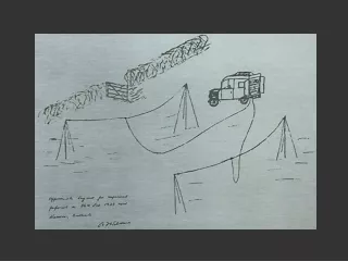
Conceived Solution • Quadtocopters placed strategically within reserves • Solar powered towers • Gun shot sensors • Image recognition • Target tracking • Possible problems • Decoy gun shots • Attacks on the quadrocopter
Approach • Incremental approach • Focusing on: • Aerial location maintenance • Gyroscope • GPS sensor • Image processing and target tracking • Fiduciary diagrams • Humans – faces, aerial view of a human body • Non-natural colours • Thermal sensors • Flight automation using: • Distance judgement using lasers • 3D mapping
Conclusion • Make technology available commercially • Benefits security and surveillance industries • New approaches to security management • Reduce cost of security over large areas