Enhanced Raingage Network in Northwest Mexico: Improving Precipitation Measurements
This project focuses on enhancing the measurement of rainfall distribution in northwest Mexico, particularly in the core monsoon region. A network of 80 tipping-bucket rain gauges has been installed across varied elevations from central Sonora to southern Sinaloa. This initiative aims to address the biases in existing networks that favor lower elevations, exploring rainfall patterns associated with topography and storm intensity variations. The data collected will improve the spatial and temporal accuracy of precipitation products, essential for hydrometeorological applications.


Enhanced Raingage Network in Northwest Mexico: Improving Precipitation Measurements
E N D
Presentation Transcript
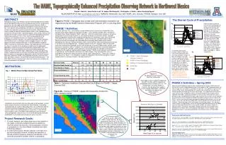
The Enhanced Raingage Network in Northwest Mexico for NAME David J. Gochis1, Juan-Carlos Leal2, W. James Shuttleworth3, Christopher J. Watts2, Jaime Garatuza Payan4 1NCAR/ASP/RAP (E-mail: gochis@rap.ucar.edu); 2IMADES, Hermosillo, Son. MX; 3HWR, Univ. Arizona; 4ITSON, Obregon, Son. MX ABSTRACT Validation of Distributed Precipitation Products: Matching the NERN Distribution to Topography: A 3 year project is underway to improve the measurement of the spatial and temporal distribution of rainfall in the core monsoon region. Tipping-bucket rain gauges with event data loggers have been installed at 80 sites in northwest Mexico in a series of (roughly) SW-NE transects which extend from central Sonora to southern Sinaloa (see http://www.imades.org/drh/index.html for a link to site location information). The sites have been chosen to provide an improved sampling of the topographic variations in the region, since the existing network reporting daily rainfall values is biased towards lower elevations. Results from summer 2002 have shown that although the amount of rain generally increases with elevation, the storms at low elevations often are of higher intensity. Also the timing is different, with maximum intensities between 2 and 5 pm at high elevations and between 5 and 8 pm at low elevations. The data is also being used to analyze the rainfall patterns associated with "gulf surges". Finally, several tipping-bucket gauges have been collocated with manual gauges so that calibration issues can be addressed. While much has been learned from various gridded precipitation products from the NAME Tier 1 region, deficiencies in both the spatial and temporal resolution of the native gage data have resulted in an inadequate depiction of the distributed precipitation regime over the NAME Tier 1 region, especially within the complex terrain region of the SMO. A lack of station density in the remote mountain regions potentially results in a smoothing of the true precipitation field. A low elevation bias in the region also exists as there is a deficiency of long term observing sites at higher elevations. There is also a distinct lack of sub-daily precipitation observations in the Tier 1 region of NW Mexico which inhibits the development of higher temporal resolution precipitation products. Using the Phase 1 NERN raingages and the NOAA/CPC 1 deg daily precipitation product, we have estimated the difference in August 2002 total precipitation as shown in Figure 5. The difference field exhibits a large range (+/- 150 mm) and an irregular pattern. Areas with significant differences are likely attributed to sparse observations and inconsistent manual observer protocols feeding the CPC gridded product. Errors of this magnitude and spatial pattern greatly complicate the application of the gridded CPC product for detailed hydrometeorlogical applications. It is proposed that integrating the NERN data into the gridded CPC product will greatly reduce such difference in future split-sample validations. Figure 2 The distribution of topography (based on a 1 km DEM) and number of NERN rain gages within 500 m elevation bands is shown in Figure 2. The overall range in elevation sampled by the NERN (71 – 2979 m) improves the sampling range of the existing daily climate observation network operated by the CNA (el. Range: 71 – 2347 m) by over 600 m. The mean elevation of the enhanced network is 1226 m compared with 886 m of the CNA climate-observing network, which helps to remove a low elevation bias in the original observational network compared with the regional topography (mean el. = 1321 m). Additionally, there are now 13 gages located at over 2000 m elevation, where before there were two. As shown later in the analyses, these new high-elevation stations are critical for analyzing temporal features of terrain-induced convective precipitation. A notable feature from Figure 2 is the dearth of gages located in the 1000-1500 m interval (El. Band 3). It is apparent from Figure 2 that there is comparatively little terrain in this elevation band along the western slope of the SMO. In fact, the terrain in this region is quite steep, rising from average valley elevations between 400-1000 m to the plateau and ridgeline elevations over 1500 m. While sampling in the 1000-1500 m band was deficient in PHASE 1 installations, PHASE 2 enhancements have increased sampling in this interval. The NAME Event Raingage Network (NERN): The NAME Event Raingage Network (NERN) is nearing full installation. To date 80 automated, event-logging raingages and 16 bulk rainwater collectors have been installed along several West-East transects within the complex terrain region of the Sierra Madre Occidental in Northwest Mexico (See Figure 1). The primary purpose of the event-logging network is to better sample the time and topographic dependency of precipitation characteristics in the Tier 1 region of NAME in support of the NAME field campaign scheduled for the summer of 2004. Bulk rainwater is analyzed for isotopic content and fractionation at the University of Arizona Tree Ring Research Laboratory. As shown in Figure 1, installation of the NERN has proceeded in 2 phases, corresponding to fiscal years 2002 and 2003. Phase 1 gages (shown as blue stars) were installed during 2002 while Phase 2 gages (shown as red stars) were installed during the spring of 2003. Additional raingages are planned to be installed during the summer and fall of 2003 in conjunction with upgrades to the operational weather radars in Northwest Mexico (Cd. Obregon, Guasave, Los Cabos and El Palmito, Dur.), thereby providing ground-based precipitation estimates critical for verifying radar-based [and satellite-based] quantitative precipitation estimates (QPE). Precipitation Characteristics in the NAM Region Preliminary diagnostics from the NERN from Aug-Sep of 2002 have been performed on Phase 1 gages and are documented in Gochis et al. (2003b).Figure 3 shows an interpolated map of wet day return periods for Phase 1 gages. On average, convective rainfall appears to initiate first and most frequently over the western slope of the SMO. Less frequent, but higher rate events occur over the lower elevation foothills and coastal plains of the region. To date, comparatively little is known about the detailed structure of the rainfall on the eastern slope of the cordillera, though recent installations to the NERN are aimed at better define precipitation characteristics in this historically under-sampled region. Future Work: Figure 6 The existence of a well-maintained event-based raingage network such as the NERN offers many opportunities for improving the understanding of regional precipitation characteristics and their relationship to forcing mechanisms in the Tier 1 region and beyond. As more data becomes available we plan to extend our existing diagnostic analyses to explore the detailed precipitation structure of transient intra-seasonal events such as ‘Gulf Surges’, monsoon breaks, MJO cycles as well as other physiographic linkages. One area we have begun to explore is that of the subregional coherence of precipitation characteristics and their relationship to streamflow generation. A principal components analysis was performed on the JAS streamflow volumes and the loading factors were then spatially interpolated to reveal regions of coherent variability (Figure 6). The first two components exhibit a N-S dipole structure. This feature has been found by Brito-Castillo et al. (2002) in their analysis of reservoir inflow volumes in the same region. However, the third principal component of streamflow variability also suggests that basins on the east-side of the SMO differ from the basins on the west, a feature recently noted by Fawcett et al. (2002). The detailed structure of each of these regions is the subject of ongoing research. Using data from 2002, there is evidence that supports a maximum in precipitation occurrence along the western slope of the SMO (See Table 1). While precipitation is less frequent at lower elevations (0-500 m) events here tend to possess higher intensities. The diurnal cycle of wet day rain rates (Fig. 4) also shows a general relationship with elevation. Precipitation usually begins earliest at the highest elevations and progressively later at lower elevations. The lowest elevation band (0-500 m) also shows evidence of nocturnal activity. Disregarding the 1000-1500 m band, the 0-500 m band has the highest wet-day hourly rain rates. (Note: The strong maximum in the 1000-1500 m el. Band is currently suspected to be an artifact of poor sampling in this region, which will be resolved after the 2003 warm season.) Figure 1 Table 1 Figure 4 References and Publications Brito-Castillo, L., A. Leyva-Contreras, A.V. Douglas, D. Lluch-Belda, 2002. Pacific decadal oscillation and the filled capacity of dams on the rivers of the Gulf of California continental watershed. Atmosfera (15), 121-138. Fawcett, P.J, J.R. Stalker and D.S. Gutzler, 2002: Multistage moisture transport into the interior of northern Mexico during the North American summer monsoon. Geophys. Res. Lett., 29(23), doi:10.1029/2002GL015693,2002. Gochis, D.J. and W. J. Shuttleworth, 2003a: The hydrometeorological response of the modeled North American Monsoon to convective parameterization. In Press, J. of Hydrometeorology. Gochis, D.J., J.-C. Leal, C.J. Watts, and W.J. Shuttleworth, 2003b: Preliminary diagnostics from a new event-based precipitation monitoring system in support of NAME. In Press, J. Hydrometeorology. Acknowledgements Support for this work was provided in part by the NOAA Joint CLIVAR/PACS-GEWEX/GAPP North American Warm Season Precipitation Initiative: Contract No. NA16GP2002 and by the Advanced Study Program at the National Center for Atmospheric Research.