Precipitation Characteristics and Streamflow Events in the North American Monsoon Region
This study analyzes the precipitation characteristics and streamflow regime in northwestern Mexico under the influence of the North American Monsoon System. It utilizes a new event-based raingage network to examine relationships between precipitation intensity, frequency, and duration and their impact on streamflow in unregulated basins. The analysis reveals distinct summer maximum flow periods and variability in low-flow seasons, influenced by tropical storms. The results underscore the complexity of hydrometeorological patterns in this region, which merits further investigation.

Precipitation Characteristics and Streamflow Events in the North American Monsoon Region
E N D
Presentation Transcript
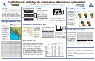
Figure 5 Precipitatioin Characteristics in the Core Region of the North American Monsoon and Their Relationship to Large Streamflow Events David J. Gochis1, Juan-Carlos Leal2, W. James Shuttleworth3, Christopher J. Watts2, Jaime Garatuza Payan4 1NCAR/ASP/RAP (E-mail: gochis@rap.ucar.edu); 2IMADES, Hermosillo, Son. MX; 3HWR, Univ. Arizona; 4ITSON, Obregon, Son. MX ABSTRACT The Streamflow Regime in NW Mexico Fig. 3 Principal Components Analysis (PCA) The mountain and coastal plain regions of the northwestern Mexico lie under the influence of the North American Monsoon System (NAMS). Recent analyses have shown this region to exhibit among the highest interannual variance in precipitation and in streamflow in the world. However, no clear relationship between large-scale teleconnective forcing (such as sea-surface temperatures) and regional hydrometeorology has yet been established. Precipitation characteristics such as intensity-frequency-duration relationships from a new event-based raingage network are presented. Correlations between the various precipitation characteristics and streamgage measurements in 15 unregulated basins in western Mexico are explored. The relationship between topography and precipitation structure are also be examined. In future studies, particular attention will be focused on the relationship between catchment topographic features and soil structure (e.g. soil type and depth) and estimates of runoff fractions. Fig. 2a The streamflow regime in NW Mexico is dominated by a strong summertime signal concomitant with summer monsoon rains (Fig. 2a). All basins show a distinct summer maximum in monthly flow volume. Interannual monthly streamflow variability (quantified as the coefficient of variation of monthly flow volume, Fig. 2b) is lowest during the summer months indicating that the higher flows are a persistent feature. There is marked flow variability in the low flow season in the spring and also in the fall. The increased variability in the late fall and early winter are likely due to land-falling tropical storms. In most basins, the months with maximum flow volume are summer months. This is not universally true though as some basins show fall and wintertime maximums. Figure 6 A principal components analysis was performed on both the JAS streamflow volumes and basin averaged precipitation. Loading factors were then spatially interpolated to reveal regions of coherent variability. Both streamflow and precipitation exhibit a N-S dipole structure in the first two components. This feature has been found by Brito-Castillo et al. (2002) in their analysis of reservoir inflow volumes in the same region. These features suggest there are two distinct modes which influence the precipitation and runoff regime in the NAM region. The third principal component of streamflow variability also suggests that basins on the east-side of the SMO differ from the basins on the west. (The third component of precip. was not discernable from higher components and therefore not deemed significant. Fig. 2b However, the clear signal in the annual cycle of streamflow does not necessarily imply increased predictability in summertime streamflows. Figure 3 shows the 1 month lag autocorrelation values for the 15 test basins. While low flow months tend to have a strong serial correlation the transitional months of May and Jun and the summer months of June, July, August, and Sept. each possess comparatively low correlation values with the respective preceding month’s streamflow. Fig. 2c The North American Monsoon Region: Selected Test Basins Precipitation Characteristics in the NAM Region Figure 1 The core region of the North American Monsoon region is characterized by steep topographic and precipitation gradients, which, in turn, result in strong gradients in vegetation. For the streamflow analysis portion of this study we have selected 15 basins which drain the Sierra Madre Occidental mountains in western Mexico (2 of which drain to the east). Drainage areas range between 1,000 and 10,000 sq. km. All basins are also unregulated by impoundments or large diversions with the exception of the San Lorenzo basin (#11) Other basin characteristics are provided in the Table 1. Figure 4 Using data from 2002, there is evidence that supports a maximum in precipitation occurrence along the western slope of the SMO. While precipitation is less frequent at lower elevations (0-500 m) events here tend to possess higher intensities. It has been suggested that runoff in the NAM region is controlled more by precipitation characteristics (intensity, duration and frequency) than by seasonal precipitation totals (Gochis et al. 2003a). We examine this first by looking at precipitation features obtained from a new event based raingage network recently established in NW Mexico. (Gochis et al. 2003b) Rainfall Runoff Correlation Structure Table 2 Table 4 The similar patterns revealed from the PC analysis above suggest that there may be a correlation between JAS precipitation (P) and streamflow (Q). Pearson correlation coefficients for all 15 basins are given in Table 4. Statistically significant correlations are present in 9 out of 15 basins. It is noticed that all of the southern basins and those that drain to the east are significantly correlated while only 2 basins from the northwestern part of the domain are. Also shown in Table 4 are correlation coefficients between the annual southern oscillation index (SOI) and JAS precipitation and streamflow. It is evident from these values that only basins in the south are significantly correlated with the SOI. It is, therefore suggested that principal component 2 revealed above is more strongly related to tropical forcing than are basins further north. The diurnal cycle of wet day rain rates (Fig. 5) also show a general relationship with elevation. Precipitation usually begins earliest at the highest elevations and progressively later at lower elevations. The lowest elevation band (0-500m) also shows evidence of nocturnal activity. Disregarding the 1000-1500 m band, the 0-500m band has the highest wet-day hourly rain rates. (Note: The strong maximum in the 1000-1500m el. Band is currently felt to be an artifact of poor sampling in this region.) Runoff Coefficient Analysis Boldface indicates correlation significant at 95% level. Table 3 To obtain an understanding of the rainfall runoff relationship in the NAM region we calculate the runoff coefficient (=discharge/precipitation) for the 15 test basins. Lacking a long time series of the event data presented above we used the 1 degree CPC gridded daily precipitation product (Higgins et al. 1996). This product is gridded from available historical gage precipitation measurements from the climate observing network across Mexico. Basin average precipitation values were calculated for each basin and used in calculation of the runoff coefficient. We used JAS (July-August-September) values of both precipitation and streamflow. Various combinations of months and 1 month lag periods were also calculated but the results changed little. As can be seen from Table 3, mean values of the seasonal runoff coefficient varied from 9-43%. Smaller values of the runoff coefficient (between 9 and 20%) appear to be confined to the northernmost basins. Standard deviations, however, were often in excess of 50% of the mean values indicating a large uncertainty in the mean values. This could indicate a large interannual variability in runoff coefficient values, but, in this case, more likely stems from problems in the precipitation data used. The two red values in the range column indicate that runoff coefficients for some periods exceeded 1.0 which is unlikely in this semi-arid region where groundwater inputs are not suspected to be significant. References and Publications Brito-Castillo, L., A. Leyva-Contreras, A.V. Douglas, D. Lluch-Belda, 2002. Pacific decadal oscillation and the filled capacity of dams on the rivers of the Gulf of California continental watershed. Atmosfera (15), 121-138. Gochis, D.J. and W. J. Shuttleworth, 2003a: The hydrometeorological response of the modeled North American Monsoon to convective parameterization. In Press, J. of Hydrometeorology. Gochis, D.J., J.-C. Leal, C.J. Watts, and W.J. Shuttleworth, 2003b: Preliminary diagnostics from a new event-based precipitation monitoring system in support of NAME. In Press, J. Hydrometeorology. Acknowledgements Support for this work was provided in part by the NOAA Joint CLIVAR/PACS-GEWEX/GAPP North American Warm Season Precipitation Initiative: Contract No. NA16GP2002 and by the Advanced Study Program at the National Center for Atmospheric Research.