The Current Situation
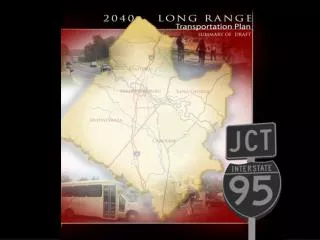
The George Washington Region, covering Fredericksburg and surrounding counties, faces escalating transportation issues due to rapid population growth and congestion. The FAMPO Long-Range Transportation Plan updates previous strategies to address transportation needs for all modes, including highways, transit, and pedestrian infrastructure. With a projected population of over 617,000 by 2040, the region must navigate funding challenges and explore various land use scenarios to ensure mobility and economic competitiveness while mitigating environmental impacts.

The Current Situation
E N D
Presentation Transcript
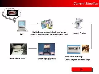
The Current Situation Existing Congested Corridors • George Washington Region includes the City of Fredericksburg and the Counties of Caroline, King George, Stafford and Spotsylvania • FAMPO area includes the City of Fredericksburg and the Counties of Stafford and Spotsylvania • FAMPO is governed by a Policy Committee - eleven elected and non-elected voting members • Non voting members include: • Caroline and King George Counties • Federal Highway Administration (FHWA) • Virginia Department of Rail and Public Transportation (DRPT) • Virginia Commonwealth Transportation Board Member • Transportation issues exist already and will worsen in the future unless addressed appropriately
Long Range Transportation Plan Overview • Plan is an update to the 2035 Plan, which made major changes to Regional transportation planning • Plan addresses the region’s future transportation system for all modes • Highways • Bicycles and Pedestrians • Transit and Transportation Demand Management (TDM) • Freight • Aviation • Plan is comprised of two parts • Needs: not constrained by revenues • Constrained: constrained by forecasted revenues • Regional dialogue is needed to address the constrained plan’s financing assumptions • Plan is a significant policy document for the region Map of the Region
Historic Growth and Development • Region has a population of more than 327,000 people • George Washington Region is the fastest-growing in Virginia • Over 400% increase in Region’s population since 1970 • Growth in Spotsylvania and Stafford Counties • 70% of all recent residential development in the Region has occurred in these counties • 75% of the recent commercial development has occurred in these counties • Recent growth has created opportunities and challenges • More services • Increase in home values • More jobs • More traffic and congestion • Increased air pollution • Environmental impacts Existing Population Density
Future Growth and Development 2040 Population Density • Region is forecasted to grow to about 617,000 persons by 2040 • Region will remain the fastest growing in Virginia • Future growth is likely to be low density and largely suburban with pockets of density identified in local Comprehensive Plans • Opportunities will increase • Auto-orientation will remain • Property values are likely to increase • More jobs will come to the Region • Challenges will become more acute • Public transportation choices will be limited • Transportation funding challenges will increase • Congestion will increase • Mobility will decrease • Auto-orientation
Land Use and Transportation • Regional Land Use Scenario Planning Study initiated in 2009 • Purpose of study was to explore and debate local and Regional growth visions, their trade-offs and alternative futures • 5 Growth Scenarios examined • Decentralized Growth • Green Print • Compact Centers & Corridors • Jobs/Housing Balance • Comprehensive Plans • Comprehensive Plans Scenario used as inputs to the FAMPO travel demand model to develop 2040 LRTP Future Land Use Assumptions
Land Use and Transportation • The State encourages land use considerations in transportation planning • Federal Law (“MAP-21”) allows multiple scenarios to be considered in MPO Long Range Plans • Land use decisions are and will be controlled by local governments, while FAMPO has developed an advisory Scenario Planning model that is integrated into its long range planning process • This modeling capability allows the Region and/or local governments to explore the implications which different land use patterns and transportation investment strategies have on the Region as a whole or on individual localities • Example models developed could show potential decreases in highway needs, depending on land use policies adopted by local governments • Data, models and other tools will continue to be available to local governments for their use in local planning efforts
2040 Long Range Transportation Plan 2040 Congestion Levels With No Highway Improvements • Region faces significant increases in travel demand over the next 27 years • Without improvements to the transportation system… • Congestion will increase on the region’s most important transportation corridors • People’s mobility will be reduced • Region’s economic competitiveness may decrease • Current funding levels are not forecasted to be sufficient to cover future transportation needs
Regional Needs Plan • Plan is not fiscally constrained • Five needs plans were developed (for both Urban and Rural areas) • Highway Needs Plan • Bicycle and Pedestrian Plan • Transit and Transportation Demand Management Plan • Freight Plan • Aviation Plan
Highway Needs Regional Highway Needs Plan • Major routes and facilities will struggle to meet travelers’ demand • Interchanges with I-95 • Major corridors such as I-95, US 1, US 17, Route 208, Route 630, Route 610…and others • Many bridges will need rehabilitation and/or replacement • Highway plan mitigates the majority of Regional traffic congestion and other transportation issues • Carries a significant cost – $12.4 billion (includes $365 million of bicycle and pedestrian needs Region-wide)
Bicycle and Pedestrian Needs Bicycle and Pedestrian Needs Plan • Closely coordinated with the highway plan • Would increase people’s non-vehicular mobility • Would close gaps in the existing network • Would create a complete system of sidewalks, bikeways, trails and other facilities
Transit and Transportation Demand Management (TDM) Needs Transit and Transportation Demand Management Needs Plan • Focused on two different transit markets • Regional market: George Washington Region • Commuter market: I-95 corridor • Increased FRED services in the region • Increased commuter services in the I-95 corridor • VRE services increased and service extended to Spotsylvania County • Express bus service to Washington DC and the Pentagon/Crystal City • Park and ride lot capacity increased • Transit centers created to support park and ride lots • Current TDM programs augmented • Vanpool and rideshare • People’s mobility will increase, but, outside the I-95 corridor, congestion will not be impacted significantly • Overall plan represents a significant expenditure – $1.5 billion
Forecasted Needs Plan Outcomes • Resulting congestion if all highway projects in Needs Plan are built • Still some congestion on I-95, primary and secondary routes in the urbanized area • Very little congestion in rural area
Financially Constrained Plan • Recommended improvements are revenue constrained • Extent of projects is limited • Many of the Region’s highways will remain congested • Fewer pedestrian and bicycle projects will be implemented • Less transit service and fewer TDM programs will be operated
Constrained Highway and Bicycle and Pedestrian Plans • Projects identified based on fiscal constraint and prioritization • Prioritization methodology adopted by the FAMPO Policy Committee • Ranks projects based on factors • Current and Future Congestion • Safety and Security • Environmental Impact • Public and Community Support • Ease of Implementation and Funding • Economic Growth and Efficient Land Use • Approximately $3.3 billion available for projects (including $2.1 billion for HOT/HOV Lane projects)
Constrained Highway and Bicycle and Pedestrian Plans • Address congestion and mobility in a limited area • Considerable investment in transportation regionally • $ 138.6 million reserved for smaller-scale projects • Fully-funded high profile projects • I-95 Express Lanes • Reconstruction/relocation of the I-95/Route 630 • Replacement of the Falmouth Bridge on U.S. 1 • Completion of Fall Hill Avenue improvements • Extension of Mary Washington Boulevard • Widening of U.S. 17 (Stafford and Spotsylvania Counties) • Improvements to Onville Road • Significant Projects for Engineering and Studies • I-95 Rappahannock River Crossing • I-95 improvements in the Jackson Gateway area of Spotsylvania County • Improvements to Lafayette Boulevard • Widening of U.S. 1 (Regionwide) Constrained Highway Plan
Forecasted Constrained Highway Plan Outcomes • Resulting highway congestion if all projects in the Constrained Plan are built • Still significant congestion on I-95, US Routes 1 & 17, as well as a number of primary and secondary routes throughout the FAMPO Area
Forecasted Constrained Transit and TDM Plan Outcomes • Virginia Railway Express • Extension of service to Spotsylvania County • FRED • Due to financial constraints, FRED service remains constant Park and Ride Expansion • Consolidation of park and ride lots with expansions to remaining lots • 4,000 new parking spaces created • Transportation Demand Management Improvements • Capital assistance for vanpools • Increased guaranteed ride home program • Carpool and vanpool incentives (for riders and drivers) • Marketing initiatives
Comment on the Plan • Public comment period for the LRTP is from January 29, 2013 to March 18, 2013 • Please submit your input via the following: • USPS: 406 Princess Anne Street, Fredericksburg, VA 22401 • Website: http://www.fampo.gwregion.org/public-notices or http://www.fampo.gwregion.org/transportation-planning-documents/long-range-transportation-planning • Email: fampo@gwregion.org • Facebook: https://www.facebook.com/FAMPO1VA • In person: During the public hearing scheduled to earlier than 7:10 p.m. on March 18, 2013. • A public hearing to adopt the final LRTP will be held on March 18, 2013