Download
1 / 26
260 likes | 503 Vues
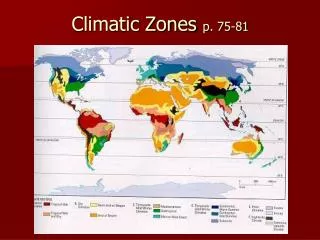
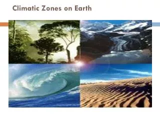
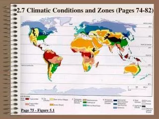
2.7 Climatic Conditions and Zones (Pages 74-82). Page 75 - Figure 5.1. Read – Textbook – Page 74.

E N D
2.7 Climatic Conditions and Zones (Pages 74-82) Page 75 - Figure 5.1
Read – Textbook – Page 74 • A climatic region is set apart from other climatic regions by a set of characteristics (i.e. temperature range, precipitation levels, patterns of sunniness or cloudiness, wind conditions, length of each season, and the way its seasons vary). • There are six climatic regions, which include: 1. Tropical; 2. Dry; 3. Temperate Mild Winter; 4. Temperate Cold Winter; 5. Polar; and 6. Highlands.
2.7.1 Describe climatic conditions within selected zones (Page 75) • Each of the 6 climate regions has sub-regions.
2.7.1 Continued • Tropical Climates • - Tropical Wet • - Tropical Wet and Dry • Dry Climates • - Semi-Arid or Steppe • - Arid or Dry • Temperate Mild Winter Climates • - Mediterranean • - Subtropical • - Marine West Coast
2.7.1 Continued • Temperate Cold Winter Climates - Continental, Warm Summer - Continental, Cool Summer - Subarctic • Polar Climates - Tundra - Icecap 6. Highlands Climate
Stuff About Climographs • Temperature is plotted as a line graph joining the 12 months of the year. • Precipitation is shown as a series of bars, one for each month.
1. Tropical Climates • All Tropical ClimatesTemperatures over 18 0C every day due to low latitude and warm ocean currents and prevailing winds blowing from equatorial region. Tropical Wet; heavy rain all year due to hot temperatures and resulting convectional rain. Tropical Wet and Dry; very heavy summer rain and very dry winter due to seasonal shift in prevailing winds. (remember monsoons from the previous section?
Tropical Climographs • Tropical Wet Climograph • Precipitation in each month is high. • Temperatures are constant and high (19-27 0C) (always above 18 º C).
Tropical Climographs • Tropical Wet and Dry Climograph • E.g. Page 76 – Bombay, India • Precipitation is very high in summer months and very low in winter months (MONSOONS) • Temperatures are relatively constant and high (19-27 0C) (always above 18 º C).
2. Dry Climates • All Dry Climates • Receive < 500 mm of precipitation annually. • More evaporation than precipitation. • Little vegetation and is windy. • Semi-arid or Steppe • Transition zone between desert and forest. • 250-500 mm of rain annually. • Arid or Desert • Occurs between 10-30 oN and 10-30 oS. • 10-250 mm of rain annually.
Dry Climographs • Arid or Desert Climograph • E.g. Page 76 - Figure 5.2 Alice Springs, Australia. • Precipitation in each month is low (total less than 250 mm). • Temperature may vary seasonally.
Dry Climographs • Semi-arid or Steppe Climograph • E.g. Page 77 - Figure 5.4 (top left climograph). • Precipitation in each month is fairly low (total less than 500 mm). • Temperature may vary seasonally.
3. Temperate Mild Winter Climate • All Temperate Mild Winter • Located in the mid-latitudes. • Mild winters. • Temperatures vary with seasons. • Mediterranean • Limited to the Mediterranean Sea area. • Marine West Coast • Is located further from the equator. • Is warmed by warm ocean currents. • Subtropical • East coast of continents. • Close to the tropics.
Temperate Mild Winter Climographs • Summer temperatures vary, but winter months (even the coldest month) are warmer than –3 oC. Marine West Coast
4. Temperate Cold Winter Climates • Summer temperatures vary, but some winter months are colder than –3 oC. Only occurs in the Northern Hemisphere Continental Warm Summer
5. Polar Climates • Short summer season. • Small amounts of precipitation. Ice Caps: Summer temperature are never above 0 oC. Tundra: Summer temperatures are never above 10 oC.
6. HIGHLANDS(Alpine) Due to elevation and involves areas higher than 1000 m. Highland climates vary depending on a combination of four factors: 1. Latitude 2. Elevation (Altitude) 3. Topography 4. Continental Location Remember: 2°C decrease/300m increase
2.7.2 Patterns of Climatic Zones • Globally speaking, where is each climatic zone concentrated? • Tropical? • Dry? • Temperate? • Polar? • Highlands?
Answers • Tropical = Near the equator and between 23.5 º N and S (i.e. Tropic of Cancer and Tropic of Capricorn). The Tropical Wet and Dry sub-region is farther from the equator from the Tropic Wet sub-region. • Dry (Desert or Arid) = Between 10 º and 30 º N and S. Also, on the west coasts of continents and on the leeward side of mountains. • Dry (Semi-Arid or Steppe) = Between the Tropical Wet and Dry sub-region and the dry Desert or Arid sub-region. • Temperate Mild Winter = Found in the mid-latitudes or on seas or ocean coasts. Mediterranean = West coasts of continents and in areas around the Mediterranean Sea. Subtropical = East coasts of continents. Marine West Coast = West coasts of continents, but at higher latitudes.
Answers • Temperate Cold Winter = Mid-latitudes similar to temperate mild winter; however, it is more continental (meaning farther inland). Subarctic sub-region = Between 50 and 70 º N. • Polar = Located north and south of 60 º. Tundra = Closer to oceans. Icecaps = Farther inland. • Highlands = Due to elevation and involves areas higher than 1000 m.
2.7.2 Practice • Do Question #2 on page 75 (Part A Only).
Georgetown, Guyana – Tropical WetBombay, India – Tropical Wet and Dry – Monsoonal, Dry winter months, and Hot.Montreal, Canada – Temperate Cold Winter – Seasonal.Alice Springs, Australia – Between Arid and Semi-Arid – Dry, Seasonal, Hot Summer.
2.7.2 Practice • Do Question #2 on page 75 (Part B Only) • Montreal and Alice Springs have the widest temperature ranges. • RE: Temperature; colder winter in Montreal and warmer summer in Alice Springs. • RE: Precipitation; more in Montreal and evenly distributed. • RE: Months of Summer; opposite summer months due to northern (J, J, A) and southern (D, J, F, M) hemispheres.
2.7.2 Practice • Do Question #2 on page 75 (Part C Only) • Different hemispheres give opposite seasons based on which months each hemisphere is tilted towards the sun and away from the sun. • Do Question #2 on page 75 (Part D Only). • Montreal = Temperate Cold Winter • Alice Springs = Semi-Arid or Steppe
Page 77 – Sites A, B, and C • Site C = Singapore = Tropical Wet • Flat and high temperature line. • Rainfall is heavy all year long. • Site B = Toronto = Continent, Cool Summer (Temperate Cold Winter) • High temperature range. • Coldest winter month is below -3 º C. • Site A = New Zealand = Marine West Coast (Temperate Mild Winter) • Warm winters. • Precipitation in both winter and summer.
Random Questions • What is the most widespread climatic zone in the low latitudes? • What are two climatic zones that have dry conditions for most of the year? • Which climatic zone is most widespread in North Africa? • Which continents do not experience continental climates (3)? • What climate zone represents St. John’s, Newfoundland?