Beam Blockage Simulations for Low-Elevation Angles at NPOL Locations
This document presents beam-blockage simulations for low-elevation angles, utilizing terrain data with approximately 1 km resolution. Developed by Steve Nesbitt and Tim Lang, the code is based on the methodologies outlined in Bech et al. (2003) and Lang et al. (2009). The simulations, conducted with the antenna at 10 m above ground and a beam-width of 0.93°, cover two locations (NPOL-loc1 and NPOL-loc7) with various elevation settings. Detailed topography and satellite imagery are provided for both locations to support analysis.

Beam Blockage Simulations for Low-Elevation Angles at NPOL Locations
E N D
Presentation Transcript
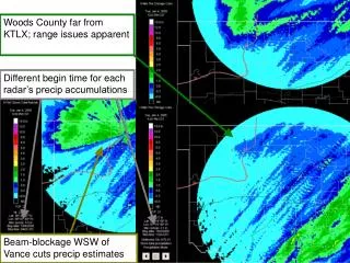
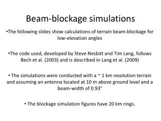
Beam-blockage simulations The following slides show calculations of terrain beam-blockage for low-elevation angles The code used, developed by Steve Nesbitt and Tim Lang, follows Bech et al. (2003) and is described in Lang et al. (2009) The simulations were conducted with a ~ 1 km resolution terrain and assuming an antenna located at 10 m above ground level and a beam-width of 0.93° The blockage simulation figures have 20 km rings.
The simulation for two locations, called NPOL-loc1 and NPOL-loc7 are presented here
Additional information on sites NPOL-loc1: Coordinates: 47.395089 N, 124.201695 W Located in an elevated area ENE of Taholah Detailed topography:
Additional information on sites NPOL-loc1: Coordinates: 47.395089 N, 124.201695 W Located in an elevated area ENE of Taholah Detailed satellite picutre:
Additional information on sites NPOL-loc7: Coordinates: 47.291552 N, 124.018092 W Located outside of Reservation on a hill SW of Lake Quinault Detailed topography:
Additional information on sites NPOL-loc7: Coordinates: 47.291552 N, 124.018092 W Located outside of Reservation on a hill SW of Lake Quinault Detailed satellite picture: