Download
1 / 37
410 likes | 824 Vues
Chapter 7: Atmospheric Disturbances. Part I: Midlatitude Disturbances. The Impact of Storms on the Landscape. Immediate storm impacts Widespread or local damage Thunder & lightning Strong winds Precipitation Flooding Long-term storm impacts Water supply Lakes/ponds

E N D
Chapter 7: Atmospheric Disturbances Part I: Midlatitude Disturbances
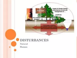
The Impact of Storms on the Landscape • Immediate storm impacts • Widespread or local damage • Thunder & lightning • Strong winds • Precipitation • Flooding • Long-term storm impacts • Water supply • Lakes/ponds • Diversity of vegetation Figure 7-B
Air Masses • Properties of air masses • Large • Diameter >1600 km • Uniform horizontal properties • Travels as 1 entity • 3 requirements: • Large • Uniform properties • Distinct from surrounding air Figure 7-2
Air Masses Figure 7-1 • Source Regions: areas that generate air masses • Remain over uniform surface long enough to acquire uniform characteristics • Extensive • Physically uniform • Stationary or H pressure • Continental or Maritime • Latitude • Affects: • Humidity • Temperature • Stability
Air Masses • Air mass classification • 2 letter classification system • Lowercase letter = moisture content • c—continental, dry • m—maritime, humid • Uppercase letter = source region • P—polar source region • T—tropical source region • A—arctic source region • E—equatorial source region
Air Masses • U.S. Air Masses • cP • mP • mT • cT • Physical geography of U.S. • No E-W mountains • Air mass clashes • Violent weather
Fronts • Front: zone of discontinuity between unlike air masses • AKA Barrier between 2 air masses • Rapid change in air properties • Temperature is most conspicuous • Move in the direction of the more active air mass • 4 primary frontal types: • Cold front • Warm front • Stationary front • Occluded front Figure 7-5
Fronts • Cold Front: cold air advancing; cold air is agressor • Faster than warm fronts • Lift warm air ahead of cold fronts • Brings colder temperatures • Heavy precipitation falls ALONG cold front Figure 7-3
Fronts • Warm Front: warm air advancing; warm air is aggressor • Gentle slope of warm air rising above cool air • Slow cloud formation • Brings warmer temperatures • Gentle precipitation falls AHEAD of warm front Figure 7-4
Fronts • Stationary front: no advance of either air mass • No aggressor air mass • Occluded front: cold air overtakes warm air • Complex Figure 7-11
Atmospheric Disturbances • 3 Types • Midlatitude disturbances—midlatitude cyclones • Localized severe weather—T-storms & tornadoes • Tropical disturbances— easterly waves & hurricanes
Midlatitude Cyclones Figure 7-6 • Midlatitude Cyclone • Large migratory L-pressure system in mid-latitudes (30-60° N/S) • Converge counterclockwise in N Hemisphere • Circulation creates fronts • Winds pull cool air from N & warm air from S • Moves with westerlies • Most significant atmospheric disturbance • Responsible for most day-to-day weather changes • Bring precipitation to much of world’s population
Midlatitude Cyclones • Weather changes behind front • Temperature: decreases as cold front passes • Winds: change from S before cold front to NW after it passes • Pressure: decreases as cold front nears & rises after it passes • Cyclone movement • Steered by jet stream • Cyclonic wind circulation • Cold front advances faster than warm front mP cP Note: the shift in winds & change in precipitation at the frontal boundaries mT
Life Cycle Cyclogenesis Birth of midlatitude cyclone Occlusion Death of midlatitude cyclone Midlatitude Cyclones Figure 7-9
Midlatitude Cyclones • Upper level divergence & convergence related to cyclogenesis Figure 7-10
Midlatitude Cyclones • Occurrence and distribution • Typically 6–15 cyclones exist worldwide • More numerous & better developed in winter than in summer • Move more equatorward during summer Figure 7-13
Midlatitude Cyclones Warm front Wrap-around precip-itation west of low Cold front
Midlatitude Cyclones Mid-latitude Cyclone 8:27a.m. 11-28-05
Midlatitude Cyclones Mid-latitude Cyclone 12:47p.m. 11-28-05
Midlatitude Cyclones Surface Temperatures associated with Mid-latitude cyclone (11-28-05)
Midlatitude Cyclones Pressure and wind associated with 11-28-05 mid-latitude cyclone
Midlatitude Cyclones Surface winds associated with 11-28-05 mid-latitude cyclone
Nor’easters • Cyclonic storm along E coast of N America; named so because winds over the area preceding the storm are from the NE • 2 Components • Gulf Stream L-pressure • Arctic H-pressure • 2 Types • Off-shore forming • On-shore forming • Nor’easter season • October – April • May dump several inches of rain and/or feet of snow • May last several days • Waves cause flooding, beach erosion & structural damage • Low temperatures & wind gusts may exceed hurricane force
Famous Nor’easters • Blizzard of 1888 • Ash Wednesday Storm of 1962 • Groundhog Day gale of 1976 • Blizzard of 1978 ("Blizzard of '78") • Halloween Nor'easter of 1991 • ("Perfect Storm") • Great Nor’easter of December 11, 1992 • Super Storm of March 13, 1993 • Blizzard of 1996 • Blizzard of 2006 • December 2009 Nor’easter • Blizzards of 2010 • 2011 Halloween Nor’easter
Rare Nor’easter Eye; Nor’easter center Note: counterclockwise flow around center
Nor’easters: Blizzard of 2006 Snow Totals • New York City – 26.9” in Central Park • Snow fell 2-5+ in/hr • Lightning/thundersnow • Washington D.C. • 8-10” • Baltimore, MD • 13-15” • Boston, MA • 15-20” • Newark, NJ (airport) • 21.3” • Fairfield, CT – 30” • Winds 20-30 mph, gusts 40-60mph
NYC National Archives Skiing to Central Park Times Square
Nor’easters: December 2009 • Snow Totals • Reagan National Airport (Washington, D.C.) – 16.4” • Brookhaven, NY – 26.3” • Philadelphia, PA – 23.2” • Boone, NC – 18” • Asheville, NC – 12” • Norwich, CT – 20” • Boston, MA – 11”
Thundersnow • Thundersnow • T-storm with snow instead of rain • 2 mechanisms: • Elevated instability • Strong lifting • Rare • Associated with intense snowfalls • Severe thundersnow • Snow with hail 3/4" or larger in diameter or if winds are 50+ mph
Midlatitude Anticyclones • Midlatitude Anticyclones—H pressure system • Subsiding, diverging windsat • Clockwise flow around anticyclone • Move with the westerlies • Larger than cyclones, but move slightly slower • Often become stationary • Relationship to cyclones • Occur independently, but have functional relationship • Anticyclone follows cyclone Figures 7-12 & 7-14