Download

1 / 14
140 likes | 279 Vues
This project, funded by the Humboldt Bay Harbor, Recreation, and Conservation District, aims to identify and catalog man-made structures affecting water flow in Humboldt Bay, California. The objectives include creating accurate maps of these structures, developing a user-friendly database of water control features, and ensuring public accessibility through a web interface. The effort has successfully documented 371 features, including tidegates and culverts, while addressing challenges like maintenance needs and data gaps related to private lands.

E N D
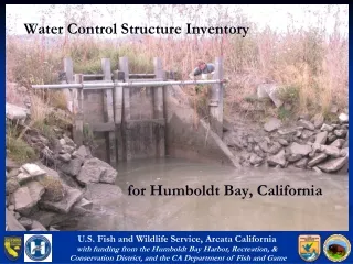
Water Control Structure Inventory for Humboldt Bay, California U.S. Fish and Wildlife Service, Arcata Californiawith funding from the Humboldt Bay Harbor, Recreation, & Conservation District, and the CA Department of Fish and Game
Project Objectives • Identify and catalog man-made structures that affect water flow within and adjacent to tidal lands. • Produce accurate maps showing locations of structures. • Produce a database populated with attribute information with an easy to use web interface and/or, • Investigate placing the data on a DFG or Harbor District – sponsored IMS site USFWS Water Control Structure Presentation
Project Steps • Identify existing data sources. • Develop a database structure that meets the needs for the restoration community • Develop a field method for collection of water control structures. • Collect field data into a GIS database containing all known water control structures. • Build a public web interface to connect to the database. • Conduct outreach to publicize the database. USFWS Water Control Structure Presentation
Existing Data • CDFG (OSPR) at one time had a dataset that was lost due to computer failure. • Existing datasets developed by CalTrans and RCAA were reviewed • CalTrans shapefile was a Humboldt County Culvert Inventory, primarily consisting of culverts along highways • Shapefile shows both ends of each culvert • Locations were based on highway postmile database • RCAA Points were approximated from descriptions in a paper publication from 2000 • Positional Accuracy is poor and variable • 31 points were defined for the Humboldt Bay region outside of duplicated CalTrans locations • Several important attributes were lacking, as well as photographs USFWS Water Control Structure Presentation
Typical data errors encountered in existing data This feature (original point location)… …is really here. This feature… …is really here. USFWS Water Control Structure Presentation
Data Collection • Trimble GeoXT GPS units were used (accuracy < 3 meters) • A data dictionary was developed containing the following fields: • Longitude and Latitude (in decimal degrees) • Type (culvert, tidegate, flash board) • Subtype (Top-Hinge round, Side-hinge, Rubber duckbill, etc.) • Material (concrete, steel, aluminum, wood, plastic) • X Dimension/Y Dimension (for non-round structures) • Current Status (functional, broken-open, broken-closed, leaking, impeded) USFWS Water Control Structure Presentation
Data Collection • Data dictionary fields (continued): • Owner (CDFG, USFWS, CalTrans, City of Arcata, etc.) • Up-Channel Habitat (fresh water, brackish, marine) • Fish Passage – Adult (suitable, limited, none) • Fish Passage – Juvenile (suitable, limited, none) • Photo Number(s) • Comments • Field Crew Initials USFWS Water Control Structure Presentation
Results • Project Area bounded by Hwy 255 on north (except entire Mad River Slough included), Hwy 101 on east (except east to Old Arcata Road and Elk River Road), and Hookton Road on south. • Currently 371 features in database, including: • 79 tidegate features • 9 Flash Board structures • 282 Culvert features • 165 of the 371 (44%) of the structures were collected with GPS and photographed USFWS Water Control Structure Presentation
Results (cont’d) • There are some structures on private lands that could not be accounted for. Where known (or seen), these structures were included using recent aerial photography as a reference • There are undoubtedly structures that we are not aware of and missed. These can always be added when we are made aware of them. • Some low level of maintenance is expected to be needed, adding and deleting points, etc. USFWS Water Control Structure Presentation
Lots of Variation in Structures USFWS Water Control Structure Presentation
Map Products – Tile 1 (Arcata) Culverts are colored redTidegates are yellow USFWS Water Control Structure Presentation
Map Products – Tile 2 (Eureka) Culverts are colored redTidegates are yellow USFWS Water Control Structure Presentation
Map Products – Tile 3 (South Bay) Culverts are colored redTidegates are yellow USFWS Water Control Structure Presentation
Remaining Issues • Private land gaps • Data maintenance • Posting to CalFish Website USFWS Water Control Structure Presentation