Download
1 / 36
360 likes | 544 Vues
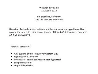
Met Brief, 20130909 Lenny Pfister, Nick Heath, and SEAC4RS met team. Convection location and timing for Wednesday Conditions in SEUS Wednesday and Friday “Deep Tropical” conditions Friday -- hurricanes MCS possibilities Wednesday and Friday.

E N D
Met Brief, 20130909Lenny Pfister, Nick Heath, and SEAC4RS met team Convection location and timing for Wednesday Conditions in SEUS Wednesday and Friday “Deep Tropical” conditions Friday -- hurricanes MCS possibilities Wednesday and Friday
200mb anticyclone over central US (displaced from 500mb anticyclone). Ample monsoon moisture feeding into convective systems propagating across the northern tier.
Wednesday Today Low level (to 5 kft) moisture is maintained in the Gulf on Wednesday, but mid-level dry air moves into northern Gulf. In fact, conditions today are clearly drier than yesterday because of this dry air.
Global models push precip close to coast, and, most importantly, further south than today.
7 AM Wednesday NAM high-res NCAR 3 km WRF NCAR Wrf maintains extensive precip off our coast.
10 AM Wednesday NAM high-res NCAR 3 km WRF
1 PM Wednesday NAM high-res NCAR 3 km WRF
Outflow pattern at top of convection different for two models off S TX coast.
Precip develops in northern MS in the afternoon – scattered T-storms in unstable air ahead of front, so have high clouds in region
Continued hot in the southeast, with low level winds counterclockwise around high. Warmest temps to western portion of SEUS.
Precip probability Max Temp
As Jim alluded to yesterday, models predict enhanced 850mb vorticity late Thursday
108 Hours (7 AM Friday), looks to be best developed circulation. HS3 considering a Thursday flight.
Outflow pattern is mostly south, but could get access to some of that in a Cuba-Yucatan flight. But best shot for getting idea of what is coming up is to go through the storm.
Pfister’sPforecast We will be flying between red and yellow line – temperatures progged to cool. EC convection east of Yucatan progged to be less than normal as pouch goes east into Gulf of Campeche. DC8 goes to developing storm, ER-2 through the Yucky strait??
Continued hot in western pocket of SEUS ahead of slowly moving front.
Based on precip probability, proximity of front, and direction of flow, high probability of severe clear will probably be in TX and southern LA.