Download
1 / 14
160 likes | 294 Vues
Strategic Regional Coastal Monitoring Programme in England. Wales Coastal and Maritime Partnership http://www.walescoastalpartnership.org.uk/ Northern Ireland Coastal and Marine Forum http://www.coastalmarineni.com/ Marine Scotland Strategic Plan 2010-2013

E N D
Strategic Regional Coastal Monitoring Programme in England Wales Coastal and Maritime Partnership http://www.walescoastalpartnership.org.uk/ Northern Ireland Coastal and Marine Forum http://www.coastalmarineni.com/ Marine Scotland Strategic Plan 2010-2013 http://www.scotland.gov.uk/About/Directorates/Wealthier-and-Fairer/Marine-Scotland Cherith Moses
Introduction Coastal groups and shoreline management plans Data requirements and strategic monitoring (Southeast England) National strategic regional coastal monitoring programme Data management centre New Forest District Council University of Southampton National Oceanography Centre
Coastal management. Coastal management in England and Wales: Shoreline Management Plans. ‘A Shoreline Management Plan (SMP) provides a large-scale assessment of the risks associated with coastal processes and presents a policy framework to reduce these risks to people and the developed, historic and natural environment in a sustainable manner.’ DEFRA (2001, p1). ‘A sediment cell is defined as a length of coastline which is relatively self-contained as far as the movement of sand or shingle is concerned and where interruption to such movement should not have a significant effect on adjacent sediment cells’ (MAFF, 1995).
Each Coastal Group has a lead authority and the membership includes: DEFRA SMPs are drawn up by a process of: consultation data collection analysis setting overall objectives plan preparation.
The subcell boundaries are ‘not definitive; they are based on best available knowledge of large scale processes’ (MAFF 1995, p1). For example, major cell 5 is subdivided into the following subcells: 5A SELSEY BILL TO PORTSMOUTH HARBOUR 5B PORTSMOUTH HARBOUR TO SOUTHAMPTON 5C SOUTHAMPTON TO HURST SPIT 5D THE NEEDLES TO FORELAND, ISLE OF WIGHT 5E FORELAND TO THE NEEDLES, ISLE OF WIGHT 5F HURST SPIT TO DURLSTON HEAD 5G DURLSTON HEAD TO PORTLAND BILL Subcell 4d: Selsey Bill to Beachy Head (http://www.sdcg.org.uk/SMP1-main.html
Each subcell is then further divided into ‘management units’: ‘A management unit is a length of shoreline with coherent characteristics in terms both of natural coastal processes and land use’ (MAFF, 1995). http://www.sdcg.org.uk/SMP1-MUD.html
Current status – 2008 onwards The Environment Agency’s Strategic Overview includes the intention to strengthen the vote of Coastal Groups by establishing:- Fewer, bigger and more strategic groups. A review of Coastal Group boundaries having regard to River Basin Management Plans and sediment cells. Clear and consistent terms of reference and membership. Coastal Groups influencing the annual programme of works via the Regional Flood Defence Committees (RFDCs). Consistent and strong Environment Agency input.
Currently 7 Coastal Groups http://www.southerncoastalgroup.org.uk/coastalgroups.htm
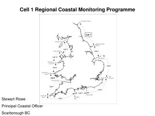
Strategic coastal monitoring • In England the strategic regional coastal monitoring programme commenced in August 2002; an initiative involving 31 Local Authority and Environment Agency partners in south-east England (1000 km). • The programme, which is grant-aided by Defra, has now extended across England with the aim of providing a consistent, repeatable and cost effective method of monitoring the coast to inform coastal risk management: - strategic shoreline management plans, - coastal defence strategies - operational management of coastal protection and flood defence. • In December 2008 a project board for the national monitoring programme was established to develop and implement the programme from 2011 onwards.
* Baseline topographic surveys of the whole region* Baseline hydrographic surveys of the whole region, * GPS control network * Annual 1:5000 aerial surveys and photogrammetric profiling * Production of digital orthophotos in years one and five * LIDAR surveys of cliffed, estuarine and inaccessible beach coastlines* Regular (annual or biannual) beach profile surveys* Spot height surveys and digital terrain models at beach management plan sites* Post storm surveys at selected sites* Annual bathymetric profile surveys at selected hold the line sites* Low level aerial surveys at selected sites * Met-office offshore hindcast wave data at 15 sites and wave transformation of offshore time-series to 35 nearshore sites* Wave time series of Hs and Tz from 8 existing and new nearshore wave recorders* Tidal time series from 16 local tide gauges and five "class A" stations
The new national network will run 2011-2015 and will provide the following data: a. Bathymetric surveys b. Topographic surveys c. Aerial surveys d. Lidar surveys e. Ecological mapping f. Hydrodynamic data collection g. Analytical services
The Channel Coastal Observatory (CCO) is the data management and regional coordination centre for the Southeast Regional Coastal Monitoring Programme. http://www.channelcoast.org/
Strategic Regional Coastal Monitoring Programme in England Coastal groups and shoreline management plans Data requirements and strategic monitoring National strategic regional coastal monitoring programme Data management centre