Exploring GIS in Academic Libraries: Enhancing Research and Resources
Geographic Information Systems (GIS) are revolutionizing academic libraries by providing powerful tools for managing and analyzing spatial data. This presentation uncovers how libraries can leverage GIS to improve research, instruction, and access to collections. Through examples and case studies, discover how platforms like Google Earth and other mapping products are being utilized to answer patron inquiries and create insightful visualizations. Join us in understanding the impact of GIS technology on library services and enhancing student experiences at the University of Arkansas!

Exploring GIS in Academic Libraries: Enhancing Research and Resources
E N D
Presentation Transcript
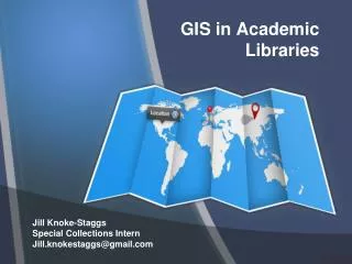
GIS in Academic Libraries Jill Knoke-Staggs Special Collections Intern Jill.knokestaggs@gmail.com
What is GIS? You are here!
UARK is already embracing GIS • http://campusmaps.uark.edu/
Spatially Yours • Example:
Why use GIS in Academic Libraries? A Picture… …is worth 1000 words • i·ro·ny • 1 [ahy-ruh-nee, ahy-er-] noun, plural i·ro·nies.1.the use of words to convey a meaning that is the opposite of its literal meaning: the irony of her reply, “How nice!” when Isaid I had to work all weekend. • 2.Literature .a.a technique of indicating, as through character or plotdevelopment, an intention or attitude opposite to thatwhich is actually or ostensibly stated. • b.(especially in contemporary writing) a manner oforganizing a work so as to give full expressiontocontradictory or complementary impulses, attitudes,etc., especially as a means of indicating detachmentfrom a subject, theme, or emotion. • 3.Socratic irony. • 4.dramatic irony. • 5.an outcome of events contrary to what was, or might have been, expected.
Definition of GIS • Geographical Information Systems is a collection of computer hardware, software (GIS program), and geographic data for capturing, managing, analyzing, and displaying all forms of geographically referenced information. • 5 elements: Hardware, Software, Data, Methods & People
Can the UA Libraries use this? • Eva Dodsworth and Andrew Nicholson, 2011, “Google Earth Usage in Academic Libraries” survey, (January, 2011, unpublished). • Over 80 responses, US and Canada • 45% use Google Mapping Products on a weekly basis (27% use them more than 3 times a week) • 82% (58) used these products to answer research questions • 61% (43) used these products for creating or accessing a finding aid tool • 56% (40) for instruction purposes • 27% for promotion/marketing • 20% (14) have used them for project work such as georeferencing imagery, for use in webpages and for training purposes • For more information on Ms. Dodsworth’s studies, pick up her book, Getting Started with GIS, A LITA Guide. Or visit her site: http://www.lib.uwaterloo.ca
Anyone can make a map! • Neogeography - Essentially, Neogeography is about people using and creating their own maps, on their own terms and by combining elements of an existing toolset. Andrew Turner, 2007. www.openstreetmap.org http://www.scribblemaps.com https://maps.google.com/
Anyone can make a map! http://www.scribblemaps.com 1st create a database then upload it…. http://www.rogersarkansas.com/cemetery/database.asp
Anyone can make a map! http://www.scribblemaps.com Choose pins and insert a key http://www.scribblemaps.com/maps/view/5T9V96wEnY
Answering Patron Questions • http://libinfo.uark.edu/SpecialCollections/univarchives/namesakes.asp
The view from up there • Sample patron question: I would like to get a better idea of the landscape around Thorncrown Chapel (designed by architect Fay Jones). Can you give me an idea?
Researchers use Google Earth • Archeologists often use satellite and aerial imagery to study land formations. This helps them determine where to locate their next dig. • This interesting looking area is Scott, AR where the Toltec Indian Mounds are located.
View historical maps Bauxite Mines Alcoa Bauxite Mines Norton-Alcoa Today (2012) • 1994 Maps could be used in the historical sketch’s of larger collections. This map references this collection http://libinfo.uark.edu/specialcollections/findingaids/ead/transform.asp?xml=mc1657&xsl=findingaid
Mapping the Stacks • Mullins Library • Tisch Library http://www.esri.com/news/arcuser/0111/tufts.html
Thank you! For more information on GIS, contact me at jill.knokestaggs@gmail.com or Kate Dougherty at kmdoughe@uark.edu