
### Comprehensive Habitat Suitability Modeling for Species Distribution Analysis ###
This guide details the systematic approach to creating habitat suitability models tailored for specific species. It emphasizes critical steps like data preparation, downloading, and uncompressing relevant datasets, and converting file formats. Utilizing various environmental layers including climate and elevation data, outputs are generated by integrating projections and indices, such as the Habitat Suitability Index, to assess the environmental conditions affecting species distribution. Case studies include modeling for Tamarisk (Tamarix spp.) and Pikas, utilizing techniques from biogeography and ecological data analysis. ###

### Comprehensive Habitat Suitability Modeling for Species Distribution Analysis ###
E N D
Presentation Transcript
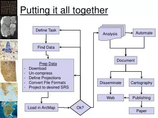
Putting it all together Analysis Define Task Automate Find Data Document • Prep Data • Download • Un-compress • Define Projections • Convert File Formats • Project to desired SRS Disseminate Cartography Web Publishing Ok? Load in ArcMap Paper
Habitat Suitability Indexes • How suitable is a habitat for a given species? • Index: • 0: Habitat inhospitable • 1: Habitat perfect • Computed from rasters representing “environmental conditions” • Elevation, climate, land cover • Distance to water, etc.
Example Layers • Global: • Climate: WorldClim • Remotely Sensed: MODIS, LantSat • Elevation: GTOPO, ETOPO • Continental US: • Climate: PRISM, DayMet: • Elevation: National Elevation Dataset • Water: National Hydrology Dataset • Local: • ?
Tamarisk – A Desert Invader Desert Museum.org Northern Arizona University
Potential Habitat Models • Tamarix spp. (Tamarisk, Salt Cedar) • Modeled from Temperature and Precipitation
Geographical Space Observed Occurrences Realized Niche/Distribution Environmental Space Fundamental Niche/Distribution Model Fitted to Occurrences Adapted from Richard Pearson, Center for Biodiversity and Conservation at the American Museum of Natural History
From the Theory of Biogeography + 0 - Salinity Environmental Space Population Growth Niche + 0 - Salinity Temperature Temperature Brown, J.H., Lomolino, M.V. 1998, Biogeography: Second Edition. Sinauer Associates, Sinauer Massachusetts
Pikas • High Elevation • Specific Temps • Specific Land Cover Types
Pika Habitat Suitability • Land cover: • Rock: 0.9 • Snow and ice: 0.7 • Herbaceous veg: 0.5 • Evergreen: 0.1 Monthly Minimum Temperature Elevation 1 1 Suitability Suitability 0 0 0 5 2500 3600 Degrees C Meters