Secondary road >4m
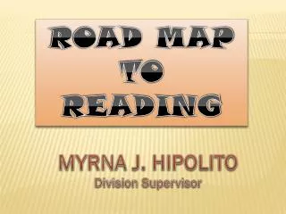
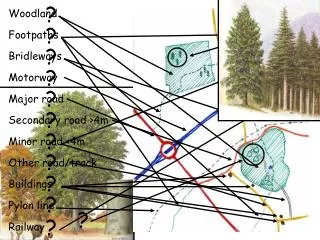
?. ?. ?. ?. ?. ?. ?. ?. ?. ?. ?. ?. ?. Woodland. Footpaths. Bridleways. Motorway. Major road. Secondary road >4m. Minor road <4m. Other road/track. Buildings. Pylon line. Railway. ?. ?. ?. ?. Contour lines. ?. Gentle slope. ?. Steep slope. Hills. Valleys.

Secondary road >4m
E N D
Presentation Transcript
? ? ? ? ? ? ? ? ? ? ? ? ? Woodland Footpaths Bridleways Motorway Major road Secondary road >4m Minor road <4m Other road/track Buildings Pylon line Railway
? ? ? ? Contour lines ? Gentle slope ? Steep slope Hills Valleys ‘Trig’ point
210 205 200 195 190 185 180 175 Height Distance
? ? ? ? Ordnance Survey Grid Grid References 12 78 12 11 . . . and up the stairs! 10 Along the corridor . . . 7 7 7 8 7 9
1 2 3 4 5 6 7 8 9 11 9 8 7 6 5 4 ? 3 2 1 10 7 9 7 8 789 102
12 11 10 7 7 7 8 7 9 780 120 78 12 789 102
12 11 10 7 7 7 8 7 9 Ordnance Survey Grid Grid References . . . and up the stairs! Along the corridor . . .
Now it’s your turn! You’ll now be split into groups. Each group will need: a sheet of paper, a set of pens, and a leader with a map • A house • A radio mast • A river • A lake • A footpath winding through these features • Each group will draw • a map showing: • A hill • A wood (mixed) • 2 types of road • A church with a Spire