Download
1 / 54
540 likes | 677 Vues
A Worldwide Information Utility… the Global Positioning System (GPS). August 2000. Overview. Policy Applications & Markets Augmentations Sustainment & Modernization International Cooperation. Policy. U.S. GPS Policy Background. Designed as a dual-use system

E N D
A Worldwide Information Utility…theGlobal Positioning System(GPS) August 2000
Overview • Policy • Applications & Markets • Augmentations • Sustainment & Modernization • International Cooperation
U.S. GPS Policy Background • Designed as a dual-use system • Military applications for multi-Service and Allied use • Civilian applications for worldwide use • Free of direct user charges (policy since 1983) • Consistent U.S. National Policy statements from both Executive and Legislative Branches • Presidential Decision Directive, March 1996 • U.S. Public Law, December 1998 • SA turned off May 2000
United States GPS Policy • Provide GPS Standard Positioning Service free of direct user fees for peaceful civil use • Encourage acceptance and integration of GPS into peaceful civil, commercial, and scientific applications worldwide • Encourage private sector investment in/ use of GPS technologies and services • Promote safety and efficiency in transportation and other fields • Promote international cooperation in using GPS for peaceful purposes • Advance scientific and technical capabilities • Strengthen and maintain national security
The Interagency GPS Executive Board Defense Transportation State Commerce Agriculture Interior NASA Joint Chiefs of Staff Justice
Worldwide Sales of GPS Goods & Services Will Reach $16B by 2003
Car Navigation • On-board navigation • Fleet management • Roadside assistance • Stolen vehicle recovery • Enhanced services • Mass market dominated by Japan • Dataquest: Unit sales of chips for car navigation to reach 11.3M in 2001 • $4.7B sales by 2003
Consumer/Recreational • Portable receivers for fishermen, hunters, hikers, cyclists, etc. • Recreational facilities -- golf courses, ski resorts • Integration of GPS into cellular phones • E-911 requirement • $3.8B market by 2003
Surveying/Mapping/GIS • Sub-centimeter accuracy • 100%-300% savings in time, cost, & labor • Control survey point: $10,000 in 1986; $250 in 1997 • Rural electrification • Telecom tower placement • Pipelines • Oil, gas, and mineral exploration • Flood plain mapping • $3.12B market by 2003
Tracking/Machine Control • Package/cargo delivery • Fleet and asset management • Theft recovery • Public safety and services • Farming, mining, and construction equipment • DGPS/RTK required for many applications • $3B market by 2003
Timing • GPS offers an inexpensive alternative to costly, high maintenance timing equipment • Telecommunications network synchronization & management • Phones, pagers, wireless systems • LANs, WANs, Internet • Financial transactions • Electrical power grid management & fault location • Digital signatures for e-commerce • Some estimate the timing market at $40-100M
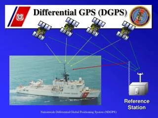
Emerging GPS Applications • Entrepreneurs and scientific researchers invent new applications almost every day • Higher precision is necessary for many cutting-edge applications • Differential GPS (DGPS) • Relative DGPS • Carrier phase positioning • Real-Time Kinematic (RTK) • Post-processing
Construction • Machinery, asset, and personnel management • Rapid surveys for laying foundation piles, etc. • Accident prevention • Remote control of machinery possible • Japanese volcano dam GPS/RTK technology was used in the construction of the Øresund Bridge between Denmark and Sweden
Europe is a Major Player in the GPS Market • Rapid growth projected, especially in car navigation sector • Many European firms provide GPS goods and services • 45 identified by Booz-Allen Hamilton • Scandanavian GNSS Industry Council • European governments are investing in GPS augmentation systems • Maritime DGPS • EGNOS • EUREF, SWEPOS, FinnNet
The Market is Wide Open • Civil signals are freely available, right now • Openly published GPS specifications allow anyone to build receivers (no licensing fees) • Hardware is becoming a commodity • Huge potential exists in value-added services • Software development • Embedded applications • Localized GIS databases • Internet integration • Wireless markets
Unit Cost of Receivers Is Falling At ~30% Per Year $800 $600 $400 $200 0 1991 1993 1995 1997 1999 Source: U.S. GPS Industry Council
GPS Modernization Service for Space Users Redundant Safety of Life Signals Increased Radiated Power Augmentations, Improved Timing Improved User Equipment
MasterControlStation(1) Monitor Station (5) Ground Antenna (4) COLORADOSPRINGS CAPE CANAVERAL KWAJALEIN HAWAII ASCENSION DIEGO GARCIA User Equipment Segment Current GPS Segments Signals in Space L2 L1 Space Segment Military P(Y) Civil (C/A) P(Y) • Block II/IIA • Operational • Rockwell (now Boeing) • 26 on orbit • MMD 6.0/8.6/10.6 yrs Ground Control Segment • Block IIR • Operational/In production • Lockheed Martin • All 21 procured • 2 on orbit • 1Destroyed on launch • MMD 7.8 yrs • Block IIF • In production • Boeing(Rockwell) • 6 already procured • Options for 24 more without modernization • MMD 12.7 yrs
Modernized GPS Space Segment • Block IIRs (up to 12 SV’s) • Adds C/A to L2 • Adds new military M-Code • Increases signal power for existing signals Signals in Space C/A C/A M-code M-code P(Y) P(Y) L1 L2 Adds civil L5 to all Block IIFs Pursue optimum Approach for higher power M-code spot beam Signals in Space C/A C/A M-code M-code P(Y) P(Y) L5 1176.45MHz L1 1575.45MHz L2 1227.6MHz GPS Modernization plan meets White House announcements of adding new civil services while implementing spectrally separated military services
RFP/SS RFP/SS GPS III Modernization FY00 01 02 03 04 05 06 07 08 09 10 11 12 13 14 Competitive Trade Studies (Two contractors) EMD Vehicles PD/RR EMD IAT GPS III SVs 1-3 transitioned to operational status Qual Vehicle Systems Arch / Rqts Study On-Orbit Test Qual Test Decision on Spot Beam Production based on Qual Vehicle Testing SV 4-6 IAT LL Prod SV 7-9 IAT LL Prod SV 10-12 IAT LL Prod GPS III Prod SV 13-15 IAT LL Prod SV 16-18 IAT LL Prod
Modernization Budget Status • DoD’s FY01 GPS Modernization budget request included both military and civil enhancements • Total request for GPS Modernization of Space and Ground Control Segment for FY01 was $440.9M • DoD’s FY01 Appropriation was enacted by Congress on August 9, 2000, at the requested level of funding
International Cooperation • Promote acceptance and peaceful use of GPS and its augmentations • International offering of GPS to ICAO and IMO • Service free of direct user charges • Non-proprietary signal standards for civil services • GPS Augmentations -- Worldwide interoperability • Space-based systems (WAAS, MSAS, EGNOS) for aviation • Land-based DGPS technology for maritime and terrestrial uses: already adopted by 35 countries • Global, non-proprietary standards
Principles for Cooperation • No direct user fees for civil and public safety services • Ensure open market driven competition for user equipment and applications • Open signal structure for all civil services to promote equal access for applications development and value added services • Protection of the current radionavigation spectrum from disruption and interference • Use of GPS time, geodesy, and signal structure standards • Seamless, global interoperability of future systems with GPS • Recognition of national and international security issues and protecting against misuse
U.S. - Japan Cooperation • September 1998: Joint Statement signed • GPS based augmentations • Largest commercial market share for products and services • September 1999: Working Groups met in Washington, D.C. • Policy • Transportation • Commercial & Scientific • Next plenary session in Tokyo
U.S. - Russia Consultation • May 19 in Washington, D.C. • Excellent dialogue • Many common views • Principles of Cooperation • Next meeting in Fall 2000 in Moscow
U.S. - E.U. • Use of GPS and its augmentations for commercial products and services incorporating open signal structure • 1998: U.S. presented draft Framework Agreement based on GPS and its augmentations • Consider inclusion of: International Advisory Commission, Intent of Guarantee, Statement of Free Service • 2000: Cooperation concept • Stage 1: Framework Cooperative Agreement based on Principles of Cooperation • Stage 2: Working groups • Stage 3: Follow-on agreement to cover Galileo operations phase
U.S. Questions About Galileo • To be understood: • Revenue stream generation • Future regulatory actions • Required use (mandate through standards) • Interoperability of free open system with fee-based encrypted system • Safety of life applications • Prevention of misuse • Open specifications and standards for equal worldwide market access • Spectrum use • Security service
Summary • GPS is a key component of the global information infrastructure • U.S. is committed to providing GPS service free of direct user fees to users worldwide • Adherence to U.S. principles has led to GPS standardization and market growth • GPS modernization is under way • U.S. is continuing international outreach to further understanding of GPS, its augmentations, and its applications • U.S. is fostering international dialogue to be responsive to global user needs
Public Services • Transportation infrastructure • Road Billing Network (ROBIN) • Snowplows • Emergency response • Law enforcement • Fire fighting • Search and rescue • Paramedics • Disaster relief
Aviation • GPS approved for en-route navigation • More efficient flight routing leads to fuel savings • Better tracking of aircraft enhances safety • Closer spacing of planes increases airspace capacity • $710M market by 2003
Maritime Navigation • GPS-based vessel tracking and traffic management maximizes effectiveness of waterways • Improved safety increases maritime commerce • Maritime DGPS service for enhanced accuracy and safety available in 34 countries • $210M market by 2003
Original Equipment Manufacturers • Chipsets • Electronic boards • Antennas, components • Standalone receivers • $690M market by 2003
Military • GPS is a recognized NATO standard • GPS is required on all U.S. military systems • Precision munitions widely used during Gulf War, Kosovo
Scientific Research • Monitoring geological change • Glaciers, tectonic plates, earthquakes, volcanoes • Wildlife behavior • Atmospheric modeling • Water vapor content • Oceanic studies • Tidal patterns • Surface mapping • Time transfer
Environmental Management • Forestry • Wetlands management • Natural resource management • Fisheries boundary enforcement • Endangered species and habitat preservation • Hazardous material cleanup • Oil spills, toxic waste
Open Pit Mining • Enhanced management of assets, equipment • Progress tracked in real-time, remotely • Improved machine control saves time, lowers maintenance and fuel consumption, prevents accidents • Rapid surveying for drilling blast holes • Smaller, more empowered workforce
Space Applications • Improved orbit and attitude control for satellites, International Space Station • Space Station return vehicle • Advance Land Observing Satellite uses GPS to calibrate high resolution radar maps • Satellite formation flying • Space launch range safety
Basic Positioning: Today 10-20 m • C/A Code on L1 Before May 2000: 25-100 m
Basic Positioning: Tomorrow Better resistance to interference 1-5 m Eliminates need for costly DGPS in many non-safety applications • C/A Code on L1 • C/A Code on L2 • New Code on L5
Advanced Positioning: Today 10 km 2 cm accuracy • L1 Code and Carrier • L2 Carrier • Data Link