Download
1 / 23
230 likes | 362 Vues
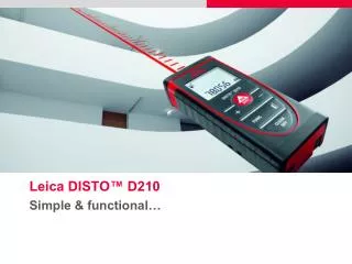
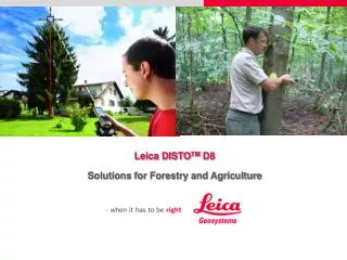
Leica DISTO TM D8 Solutions for Forestry and Agriculture. 1x. 2x. 4x. 0.000m. 0.000m. 0.000m. Perfect Features for Outdoor Applications Digital Pointfinder & Colour Display.

E N D
Leica DISTOTM D8 Solutions for Forestry and Agriculture
1x 2x 4x 0.000m 0.000m 0.000m Perfect Features for Outdoor ApplicationsDigital Pointfinder & Colour Display The 2.4” Vibrant Color Display with 4x zoom makes finding and aiming targets much easier and causes less strain to the eyes when using an optical viewfinder or trying to find or aim the laser dot at the target. Black and white mode can also e set for enhanced contrast, ideal in where the target and background is of the same colour.
Perfect Features for Outdoor ApplicationsLong Range, Timer, Tripod Mode The Long Range Mode (LR Mode) allows for distances to be measured reliably even in natural lighting conditions Given the right conditions, the effective range of 200m is achievable requiring a measuring time of 7 seconds and a target plate. Thus it is recommended to mount the unit on a tripod as the units come with a brass female thread. The tripod changes the measuring reference to the tripod thread. Timer function help minimise movement of the unit when the ON/Off button is pressed. By holding down the On/Off button to activate the continuous mode will increase the chances of getting a reading but will require a longer time.
Leica DISTO™ D5Technical Specifications • Range: 0.05 – 200m • Typ. accuracy ± 1.0 mm • Smallest unit displayed 0.0000 m • Digital pointfinder (4x zoom) • 2,4” vibrant colour display with 320 x 240 resolution • Inclination sensor ± 45° @ 0.3° accuracy • Long Range (LR) Mode • Flip-out end piece with automatic detection • Tripod thread (metal) • Functions: Area Volume Trapezium Stake-out Timer Pythagoras Triangle & Polygon Area Memory Indirect Horizontal Distance
Improvements overLeica DISTO™ D5 • 360o Tilt Sensor • Bluetooth Connectivity and Navigation Keys • 0.1o Accuracy to housing • Advanced Indirect Measurement Technology • Real-time Vertical Tracking Capability • Horizontal Profiling Capability Leica DISTOTMD5 Leica DISTOTMD8
Tree Height Measurement Remote Elevation Function (D8 model only) Take the reference measurement reading at the base of the tree. Real time height is automatically tracked as you move the digital pointer up. 2nd measurement point does not need a stationary, nor reflective surface so the movement of the canopy will not pose a problem • Benefits • 1 man operation • Minimum equipment needed • Measurement from a distance • Several trees can be measured from 1 location • Reliable tree heights results in better allocation of safety area to cut down trees Reference Measurement
Tree Height Measurement Indirect Vetical Measurement (D5 & D8 modes ) It is common when the base of the tree is hidden from view. By using the Indirect Horizontal to take 2 measurements, press and hold the function key, the calculated vertical data will be displayed. Adding both calculated vertical measurements, the tree height can be derived. Tree height = A + B Calculated Vertical B Measurement 2 Calculated Vertical A Measurement 1 Note: the reliability of the calculated height depends on the elevation changes of the ground
Second Point Tree Height First point Trunk Height Reference Measurement Monitoring Tree Growth Remote Elevation Function (D8 model only) The canopy & trunk heights can be determined by 1 reference point Starting at the base of the tree, move the Digital Pointfinder to the top of the trunk and note the Trunk Height. Move the Digital Pointfinder to the top of the tree to determine the Tree Height. Canopy Height = Tree Height – Trunk Height • Benefits • Reliable data • No need for climbing equipments
X Tree Height MeasurementMeasurement of Tilted Trees Y Double Tilt Measurement (D8 model only) Where the tree is located on a higher ground and the base is not visible Take the first measurement at the foot of the elevated ground and the second at the top of the tree Press and hold the function key to display calculated X & Y data. The measured tree height is calculated on the assumption that the 1st measurement point is on the same elevation as the second Y X • Benefits • Some locations are impossible to access • Safety and no need for climbing equipment Note: the reliability of the calculated height depends on the elevation changes of the ground
Y X Tree Height Measurement (Tilted Trees)Indirect Measurement Double Tilt Measurement (D8 model only) Take the base and top measurements and the calculated tree height will automatically displayed. Press and hold the function key, the angle of the tree’s tilt will also be displayed. Y Calculated Tree Height • Benefits • Quick and simple solution to a tree’s true height X
Tree / Vegetation DensityArea Calculation Triangle Function (D5 & D8 models ) Triangulate a few small plots and measure the 3 sides of the triangle to determine the area. Count the number of trees to derive the density The average would constitute the density • Benefits • Near impossible to plot a square or rectangle without help of instruments • so the triangle provides the most reliable source of area calculation
Plot VerificationArea Calculation Triangle Function (D5 & D8 models ) In situations where a plot of forest needs to be verified against master blueprints, aerial photographs may be a costly solution But in a small plot a cost effective solution would be to use the triangle function By using the addition function with the triangle angle function, the area of any plot shape can be systematically calculated 1 3 2 4 • Benefits • Near impossible to plot a square or rectangle without help of instruments • so the triangle provides the most reliable source of area calculation 5 6
Y X Monitoring Soil MovementsIndirect Measurement • Double Tilt Measurement ( D8 model only ) • In areas of potential erosion or landslides, monitoring the movement of the ground is conducted on a periodical basis • The calculated data provides the user with a 3 dimensional data base to which to better monitor the rate of erosion or movement: • - Diagonal Distance between posts (Z) • Slope angle () • Horizontal Spacing (X) • Vertical Spacing (Y) Y Z X The use of Bluetooth, the measured data can be wireless transmitted onto an Excel file to eliminate data entry errors
H Monitoring Soil MovementsChanges in Height between Points Horizontal Profiling ( D8 model only ) In monitoring erosion, several posts/markers would be set in the area. Using the Horizontal Profiling Function, the height difference between each marker and the first is recorded periodically The use of Bluetooth, the measured data can be wireless transmitted onto an Excel file to eliminate data entry errors
Planting / Seeding Stakeout Function (D5 & D8 models ) In Reforestation there is a need to ensure every seedling/tree will have sufficient space to grow. In the case of Agriculture; the importance of optimal use of the land. The stakeout function ensures that equal space between the plants / crops. A A A
Land Preparation for Agriculture Horizontal Profiling ( D8 model only ) Studies have shown that a level ground would require less water and minimise weed growth. Before land leveling can begin, a simple survey of the land helps determine the average height to set for the leveling. With several markers on the field, the user can quickly determine the elevation profile of the plot without the need for a staff • Benefits • Easy compared to conventional an optical level and staff • No eye strain from using optical level • 1 person operation
Grain StorageVerifying Storage Levels Indirect Vetical Measurement (D8 modes ) In developed countries where grain/wheat is stored in silos, a measure stick is sometimes used. This poses a problem when the grain level is low and the silo very tall. In large silos, grain level markers are sometimes used and the farmer merely has to peer inside with a torch, giving rise to the risk of a fall into the silo. Using the indirect measurement with the tilt sensor, the vertical height B can be measured and the gain level be quickly calculated. Grain Level = Total Silo Height – Indirect Vertical Indirect Vertical Total Silo Height • Benefits • Safety • no need for different measure stick for dfferent silos
Summary of ApplicationsUsers (Models Used) • Monitor tree growth rate, maturity and development. • Users : Agriculture and Parks Offices in USA, Europe, Asia (A8, D8) • Ensure trees along runway do not exceed height limit • User: Civil Aviation Authority of Singapore (A8 & D8) • Plan for safety zone when chopping down a tree • User: Agriculture Office, Baden Wuttemberg, Germany (D8) • Check for Tree / Shrub density (number / 50m2) • Users : Forestry depts. • Checking Slopes and Landslide Prevention • Users : Land Authority / Forestry depts
Leica DISTOTM Distance MeterCompared to current methods • One Person Operation / Measurements • Indirect Measurements Now Possible from a Distance • No need for Climbing Equipments • Multi-Functional Device – heights, lengths, areas, angles • Wireless Data Transfer to Tablet PC, Laptop for data recording and collation Disclaimer: The applications shown are examples and suggestions for possible solutions. The reliability, accuracy and ability to use such applications depend on the proper setup, positioning, skill ad ability of the operator and the conditions of the site.